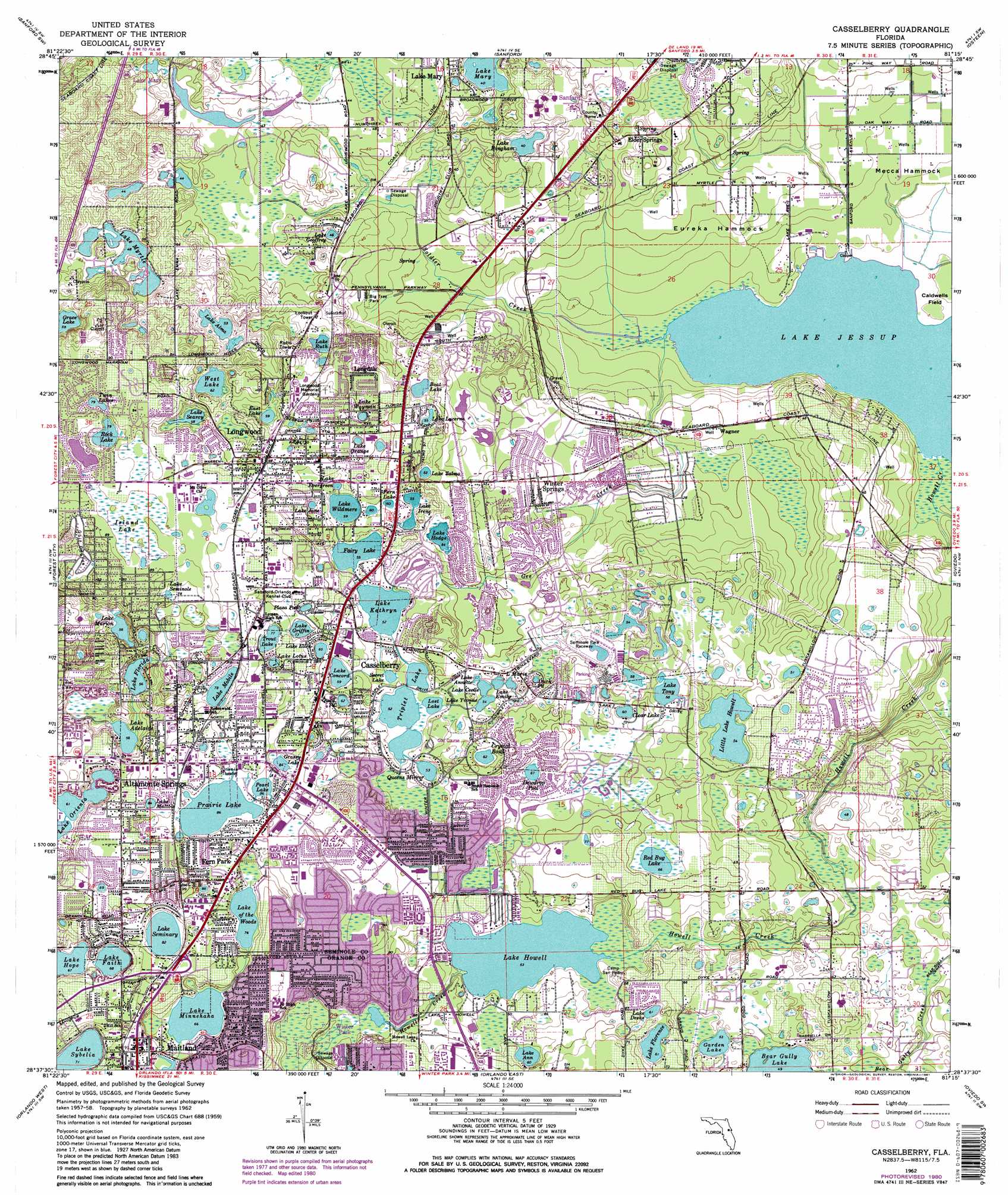
Casselberry Topo Map Florida
To zoom in, hover over the map of Casselberry
USGS Topo Quad 28081f3 - 1:24,000 scale
| Topo Map Name: | Casselberry |
| USGS Topo Quad ID: | 28081f3 |
| Print Size: | ca. 21 1/4" wide x 27" high |
| Southeast Coordinates: | 28.625° N latitude / 81.25° W longitude |
| Map Center Coordinates: | 28.6875° N latitude / 81.3125° W longitude |
| U.S. State: | FL |
| Filename: | O28081F3.jpg |
| Download Map JPG Image: | Casselberry topo map 1:24,000 scale |
| Map Type: | Topographic |
| Topo Series: | 7.5´ |
| Map Scale: | 1:24,000 |
| Source of Map Images: | United States Geological Survey (USGS) |
| Alternate Map Versions: |
Casselberry FL 1962, updated 1964 Download PDF Buy paper map Casselberry FL 1962, updated 1970 Download PDF Buy paper map Casselberry FL 1962, updated 1976 Download PDF Buy paper map Casselberry FL 1962, updated 1981 Download PDF Buy paper map Casselberry FL 1962, updated 1981 Download PDF Buy paper map Casselberry FL 1994, updated 2000 Download PDF Buy paper map Casselberry FL 2012 Download PDF Buy paper map Casselberry FL 2015 Download PDF Buy paper map |
1:24,000 Topo Quads surrounding Casselberry
Paisley |
Pine Lakes |
Orange City |
Lake Helen |
Lake Ashby |
Sorrento |
Sanford Sw |
Sanford |
Osteen |
Osceola |
Apopka |
Forest City |
Casselberry |
Oviedo |
Geneva |
Winter Garden |
Orlando West |
Orlando East |
Oviedo Sw |
Bithlo |
Windermere |
Lake Jessamine |
Pine Castle |
Narcoossee Nw |
Narcoossee Ne |
> Back to 28081e1 at 1:100,000 scale
> Back to 28080a1 at 1:250,000 scale
> Back to U.S. Topo Maps home
Casselberry topo map: Gazetteer
Casselberry: Airports
Ferguson Seaplane Base elevation 0m 0′Florida Hospital-Altamonte Heliport elevation 26m 85′
Prairie Lake Private Res Sp Mooring Facility Seaplane Base elevation 26m 85′
Casselberry: Bays
Soldier Creek Cove elevation 0m 0′Casselberry: Capes
Cabbage Hammock Point elevation 1m 3′Casselberry: Cliffs
Caldwell Point elevation 2m 6′Casselberry: Islands
Caldwells Field elevation 1m 3′Eureka Hammock elevation 4m 13′
Mecca Hammock elevation 3m 9′
Casselberry: Lakes
Boat Lake elevation 15m 49′Clear Lake elevation 19m 62′
Crystal Bowl elevation 19m 62′
Dewdrop Pool elevation 21m 68′
Duck Pond elevation 16m 52′
East Lake elevation 17m 55′
Fern Lake elevation 19m 62′
Garden Lake elevation 16m 52′
Grace Lake elevation 18m 59′
Grassy Lake elevation 25m 82′
Lake Adelaide elevation 17m 55′
Lake Alma elevation 16m 52′
Lake Ann elevation 19m 62′
Lake Annette elevation 16m 52′
Lake Bingham elevation 12m 39′
Lake Cecile elevation 16m 52′
Lake Concord elevation 18m 59′
Lake Deeks elevation 19m 62′
Lake Ellen elevation 20m 65′
Lake Emily elevation 16m 52′
Lake Evergreen elevation 17m 55′
Lake Fairy elevation 16m 52′
Lake Faith elevation 20m 65′
Lake Florence elevation 18m 59′
Lake Florida elevation 17m 55′
Lake Geoffrey elevation 15m 49′
Lake Griffin elevation 22m 72′
Lake Hodge elevation 16m 52′
Lake Hope elevation 20m 65′
Lake Howell elevation 16m 52′
Lake Irene elevation 16m 52′
Lake Jane elevation 19m 62′
Lake Kathryn elevation 16m 52′
Lake Lotus elevation 23m 75′
Lake Lotus elevation 24m 78′
Lake Lucerne elevation 18m 59′
Lake Maltbie elevation 25m 82′
Lake Maria elevation 16m 52′
Lake Marie elevation 16m 52′
Lake Marion elevation 17m 55′
Lake Minnehaha elevation 20m 65′
Lake Mobile elevation 23m 75′
Lake Myrtle elevation 14m 45′
Lake of the Woods elevation 23m 75′
Lake Orange elevation 20m 65′
Lake Prairie elevation 26m 85′
Lake Ruth elevation 17m 55′
Lake Searcy elevation 17m 55′
Lake Seminary elevation 25m 82′
Lake Seminole elevation 24m 78′
Lake Sybelia elevation 21m 68′
Lake Talmo elevation 16m 52′
Lake Tony elevation 17m 55′
Lake Wayman elevation 21m 68′
Lake Wildmere elevation 18m 59′
Lake Yvonne elevation 16m 52′
Lily Lake elevation 11m 36′
Little Lake Howell elevation 16m 52′
Lost Lake elevation 16m 52′
Pearl Lake elevation 26m 85′
Plaza Pool elevation 22m 72′
Quail Pond elevation 19m 62′
Queens Mirror elevation 15m 49′
Red Bug Lake elevation 20m 65′
Rock Lake elevation 24m 78′
Secret Lake elevation 16m 52′
Triplet Lake elevation 16m 52′
Trout Lake elevation 23m 75′
Twin Lakes elevation 23m 75′
West Lake elevation 19m 62′
Casselberry: Parks
Big Tree Park elevation 9m 29′Casselberry: Populated Places
Altamonte Springs elevation 26m 85′Casselberry elevation 17m 55′
Clifton elevation 13m 42′
Elder Springs elevation 16m 52′
Evansdale elevation 16m 52′
Fern Park elevation 29m 95′
Fern Park Mobile Home Park elevation 30m 98′
Hacienda Village Mobile Home Park elevation 10m 32′
Helen Street Mobile Home Park South elevation 20m 65′
Lake Kathryn Estates Mobile Home Park elevation 16m 52′
Lake of the Woods Trailer Park elevation 28m 91′
Lake View elevation 13m 42′
Longdale elevation 22m 72′
Longwood elevation 22m 72′
Maitland elevation 27m 88′
Midway Park elevation 12m 39′
Spring Hammock Trailer Park elevation 10m 32′
Tuskawilla Trails Mobile Home Park elevation 10m 32′
Wagner elevation 8m 26′
Whispering Oaks Mobile Home Village elevation 20m 65′
Winter Springs elevation 16m 52′
Casselberry: Post Offices
Casselberry Post Office elevation 27m 88′Fern Park Post Office elevation 28m 91′
Longwood Post Office elevation 25m 82′
Maitland Post Office elevation 27m 88′
Prairie Lake Station Post Office elevation 27m 88′
Casselberry: Streams
Gee Creek elevation 1m 3′Howell Creek elevation 1m 3′
Soldier Creek elevation 0m 0′
Casselberry: Swamps
Gee Hammock elevation 9m 29′Island Lake elevation 25m 82′
Casselberry digital topo map on disk
Buy this Casselberry topo map showing relief, roads, GPS coordinates and other geographical features, as a high-resolution digital map file on DVD: