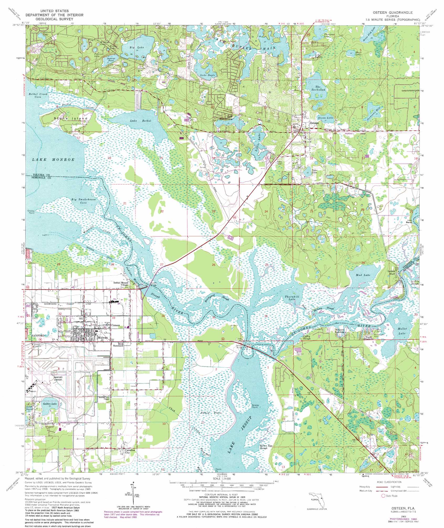
Osteen Topo Map Florida
To zoom in, hover over the map of Osteen
USGS Topo Quad 28081g2 - 1:24,000 scale
| Topo Map Name: | Osteen |
| USGS Topo Quad ID: | 28081g2 |
| Print Size: | ca. 21 1/4" wide x 27" high |
| Southeast Coordinates: | 28.75° N latitude / 81.125° W longitude |
| Map Center Coordinates: | 28.8125° N latitude / 81.1875° W longitude |
| U.S. State: | FL |
| Filename: | O28081G2.jpg |
| Download Map JPG Image: | Osteen topo map 1:24,000 scale |
| Map Type: | Topographic |
| Topo Series: | 7.5´ |
| Map Scale: | 1:24,000 |
| Source of Map Images: | United States Geological Survey (USGS) |
| Alternate Map Versions: |
Osteen FL 1965, updated 1968 Download PDF Buy paper map Osteen FL 1965, updated 1972 Download PDF Buy paper map Osteen FL 1965, updated 1981 Download PDF Buy paper map Osteen FL 2012 Download PDF Buy paper map Osteen FL 2015 Download PDF Buy paper map |
1:24,000 Topo Quads surrounding Osteen
Lake Woodruff |
De Land |
Daytona Beach Sw |
Samsula |
New Smyrna Beach |
Pine Lakes |
Orange City |
Lake Helen |
Lake Ashby |
Edgewater |
Sanford Sw |
Sanford |
Osteen |
Osceola |
Maytown |
Forest City |
Casselberry |
Oviedo |
Geneva |
Aurantia |
Orlando West |
Orlando East |
Oviedo Sw |
Bithlo |
Titusville Sw |
> Back to 28081e1 at 1:100,000 scale
> Back to 28080a1 at 1:250,000 scale
> Back to U.S. Topo Maps home
Osteen topo map: Gazetteer
Osteen: Airports
Central Florida Regional Airport elevation 14m 45′Osteen: Bays
Bethel Creek Cove elevation 0m 0′Big Smokehouse Cove elevation 0m 0′
Jacksons Bay elevation 11m 36′
Osteen: Bends
Iron Bend elevation 0m 0′Osteen: Bridges
Geneva Bridge elevation 1m 3′Osteen Bridge elevation 0m 0′
Osteen: Canals
Monroe Canal elevation 0m 0′Osteen: Capes
Grassy Point elevation 0m 0′Grassy Point elevation 1m 3′
Osteen: Guts
Brickyard Slough elevation 0m 0′Coffey Slough elevation 0m 0′
Hickory Slough elevation 0m 0′
Indian Mound Slough elevation 0m 0′
Rotten Egg Slough elevation 0m 0′
Snake Creek elevation 0m 0′
Osteen: Islands
Beck Hammock elevation 2m 6′Mothers Arms elevation 1m 3′
Stone Island elevation 1m 3′
Osteen: Lakes
Acorn Fish Lake elevation 8m 26′Beany Pond elevation 7m 22′
Big Lake elevation 7m 22′
Black Lake elevation 9m 29′
Dixon Lake elevation 9m 29′
Golden Lake elevation 11m 36′
Jenkins Pond elevation 7m 22′
Lake Bethel elevation 0m 0′
Lake Butler Chain elevation 7m 22′
Lake Doyle elevation 7m 22′
Lake Eulalia elevation 9m 29′
Lake Hutchinson elevation 7m 22′
Lake Onora elevation 13m 42′
Little Lake elevation 7m 22′
Mud Lake elevation 0m 0′
Mullet Lake elevation 0m 0′
Outlook Lake elevation 16m 52′
Panama Lake elevation 14m 45′
Saint Johns Lake elevation 16m 52′
Tanner Lake elevation 14m 45′
The Savannah elevation 8m 26′
Thompson Lake elevation 10m 32′
Thormpson Pond elevation 15m 49′
Thornhill Lake elevation 0m 0′
Tyler Lake elevation 8m 26′
Osteen: Populated Places
Beck Hammock elevation 6m 19′Boden elevation 7m 22′
Cameron City elevation 4m 13′
Canaan elevation 6m 19′
Geigers Landing elevation 2m 6′
Indian Mound Village elevation 4m 13′
Lemon Bluff elevation 4m 13′
Midway elevation 7m 22′
Mullet Lake Park elevation 1m 3′
Osteen elevation 15m 49′
Palm Shadows elevation 1m 3′
Paradise Lakes Travel Trailer Park elevation 21m 68′
Roseland Park elevation 8m 26′
Osteen: Post Offices
Osteen Post Office elevation 14m 45′Osteen: Streams
Bethel Creek elevation 0m 0′Chub Creek elevation 0m 0′
Three Otter Creek elevation 0m 0′
Woodruff Creek elevation 0m 0′
Osteen: Swamps
Naked Place elevation 1m 3′Osteen digital topo map on disk
Buy this Osteen topo map showing relief, roads, GPS coordinates and other geographical features, as a high-resolution digital map file on DVD: