Sorrento Topo Map Florida
To zoom in, hover over the map of Sorrento
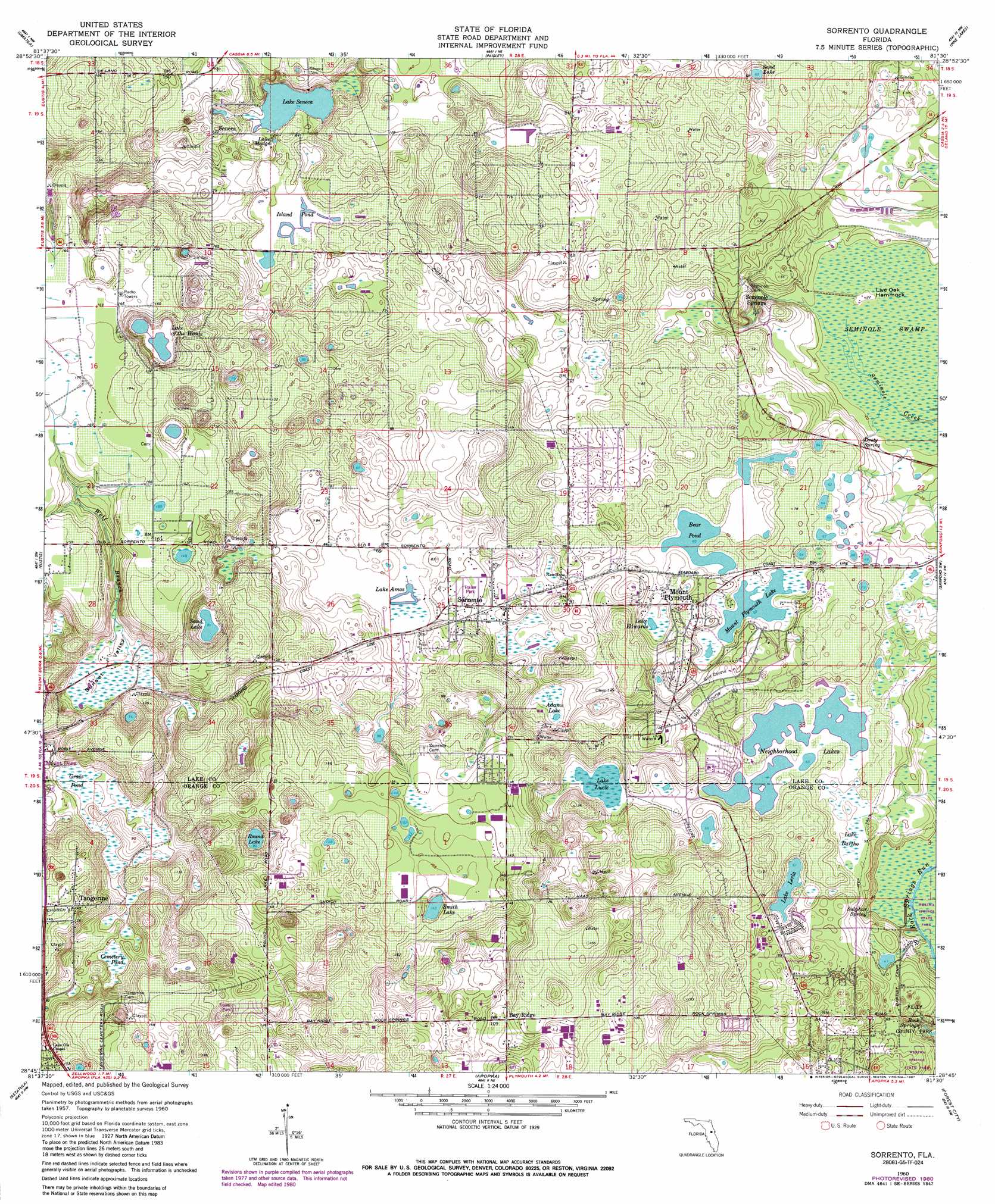
USGS Topo Quad 28081g5 - 1:24,000 scale
| Topo Map Name: | Sorrento |
| USGS Topo Quad ID: | 28081g5 |
| Print Size: | ca. 21 1/4" wide x 27" high |
| Southeast Coordinates: | 28.75° N latitude / 81.5° W longitude |
| Map Center Coordinates: | 28.8125° N latitude / 81.5625° W longitude |
| U.S. State: | FL |
| Filename: | O28081G5.jpg |
| Download Map JPG Image: | Sorrento topo map 1:24,000 scale |
| Map Type: | Topographic |
| Topo Series: | 7.5´ |
| Map Scale: | 1:24,000 |
| Source of Map Images: | United States Geological Survey (USGS) |
| Alternate Map Versions: |
Sorrento FL 1960, updated 1962 Download PDF Buy paper map Sorrento FL 1960, updated 1976 Download PDF Buy paper map Sorrento FL 1960, updated 1981 Download PDF Buy paper map Sorrento FL 1960, updated 1987 Download PDF Buy paper map Sorrento FL 2012 Download PDF Buy paper map Sorrento FL 2015 Download PDF Buy paper map |
1:24,000 Topo Quads surrounding Sorrento
Lake Mary |
Farles Lake |
Alexander Springs |
Lake Woodruff |
De Land |
Emeralda Island |
Umatilla |
Paisley |
Pine Lakes |
Orange City |
Leesburg East |
Eustis |
Sorrento |
Sanford Sw |
Sanford |
Hewey In The Hills |
Astatula |
Apopka |
Forest City |
Casselberry |
Clermont West |
Clermont East |
Winter Garden |
Orlando West |
Orlando East |
> Back to 28081e1 at 1:100,000 scale
> Back to 28080a1 at 1:250,000 scale
> Back to U.S. Topo Maps home
Sorrento topo map: Gazetteer
Sorrento: Airports
Tangerine Airport elevation 41m 134′Sorrento: Islands
Live Oak Hammock elevation 6m 19′Sorrento: Lakes
Adams Lake elevation 17m 55′Bear Pond elevation 18m 59′
Island Pond elevation 20m 65′
Lake Amos elevation 19m 62′
Lake Bundy elevation 20m 65′
Lake Edwards elevation 17m 55′
Lake Kitty elevation 17m 55′
Lake Lerla elevation 18m 59′
Lake Lucie elevation 18m 59′
Lake Madge elevation 22m 72′
Lake of the Woods elevation 34m 111′
Lake Seneca elevation 22m 72′
Mount Plymouth Lake elevation 18m 59′
Prays Pond elevation 20m 65′
Round Lake elevation 26m 85′
Sand Lake elevation 18m 59′
Sand Lake elevation 27m 88′
Smith Lake elevation 43m 141′
Sorrento: Parks
Kelly Park elevation 18m 59′Wekiwa Springs State Park elevation 7m 22′
Sorrento: Populated Places
Bay Ridge elevation 34m 111′Brightwood Manor Trailer Park elevation 30m 98′
Mount Plymouth elevation 24m 78′
Mount Plymouth Lakes elevation 23m 75′
Oak Springs Mobile Home Community elevation 28m 91′
Oak Tree Park elevation 33m 108′
Seminole Springs elevation 20m 65′
Seneca elevation 37m 121′
Sorrento elevation 21m 68′
Valley Mobile Home Park elevation 36m 118′
Sorrento: Post Offices
Mount Post Office Plymouth (historical) elevation 24m 78′Sorrento Post Office elevation 24m 78′
Sorrento: Springs
Droty Spring elevation 8m 26′Rock Springs elevation 9m 29′
Sulphur Spring elevation 10m 32′
Sorrento: Streams
Wolf Branch elevation 24m 78′Sorrento: Swamps
Cemetery Pond elevation 20m 65′Grass Pond elevation 20m 65′
Lake Bartho elevation 17m 55′
Neighborhood Lakes elevation 19m 62′
Sorrento: Valleys
Sunset Valley elevation 24m 78′Sorrento digital topo map on disk
Buy this Sorrento topo map showing relief, roads, GPS coordinates and other geographical features, as a high-resolution digital map file on DVD: