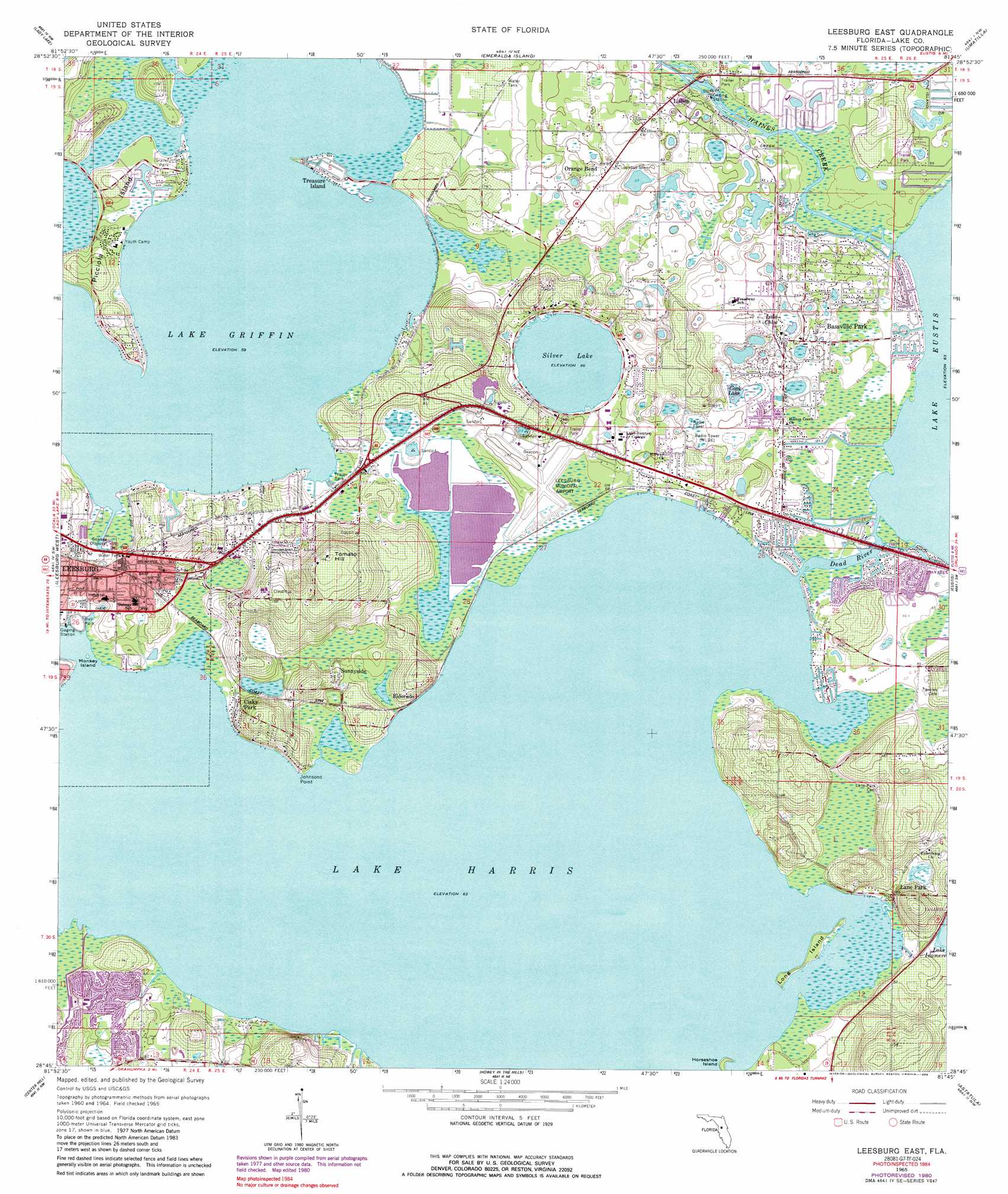
Leesburg East Topo Map Florida
To zoom in, hover over the map of Leesburg East
USGS Topo Quad 28081g7 - 1:24,000 scale
| Topo Map Name: | Leesburg East |
| USGS Topo Quad ID: | 28081g7 |
| Print Size: | ca. 21 1/4" wide x 27" high |
| Southeast Coordinates: | 28.75° N latitude / 81.75° W longitude |
| Map Center Coordinates: | 28.8125° N latitude / 81.8125° W longitude |
| U.S. State: | FL |
| Filename: | O28081G7.jpg |
| Download Map JPG Image: | Leesburg East topo map 1:24,000 scale |
| Map Type: | Topographic |
| Topo Series: | 7.5´ |
| Map Scale: | 1:24,000 |
| Source of Map Images: | United States Geological Survey (USGS) |
| Alternate Map Versions: |
Leesburg East FL 1965 Download PDF Buy paper map Leesburg East FL 1965, updated 1966 Download PDF Buy paper map Leesburg East FL 1965, updated 1989 Download PDF Buy paper map Leesburg East FL 2012 Download PDF Buy paper map Leesburg East FL 2015 Download PDF Buy paper map |
1:24,000 Topo Quads surrounding Leesburg East
Belleview |
Lake Weir |
Lake Mary |
Farles Lake |
Alexander Springs |
Oxford |
Lady Lake |
Emeralda Island |
Umatilla |
Paisley |
Wildwood |
Leesburg West |
Leesburg East |
Eustis |
Sorrento |
Bushnell |
Center Hill |
Hewey In The Hills |
Astatula |
Apopka |
Webster |
Mascotte |
Clermont West |
Clermont East |
Winter Garden |
> Back to 28081e1 at 1:100,000 scale
> Back to 28080a1 at 1:250,000 scale
> Back to U.S. Topo Maps home
Leesburg East topo map: Gazetteer
Leesburg East: Airports
L R M C Emergency Helistop elevation 26m 85′Leesburg Municipal Airport elevation 21m 68′
Leesburg East: Bridges
Slater Cox Bridge elevation 19m 62′Leesburg East: Capes
Johnsons Point elevation 19m 62′Leesburg East: Channels
Dead River elevation 19m 62′Leesburg East: Islands
Horseshoe Island elevation 20m 65′Long Island elevation 20m 65′
Monkey Island elevation 19m 62′
Picciola Island elevation 22m 72′
Treasure Island elevation 18m 59′
Leesburg East: Lakes
Cook Lake elevation 20m 65′Lake Chloe elevation 20m 65′
Lake Griffin elevation 18m 59′
Lake Harris elevation 19m 62′
Silver Lake elevation 20m 65′
Leesburg East: Parks
Woodlea Sports Complex elevation 24m 78′Leesburg East: Populated Places
Bassville Park elevation 21m 68′Beach Mobile Park elevation 21m 68′
Bonfire Mobile Home Village elevation 23m 75′
Brittany Estates Mobile Home Park elevation 24m 78′
Cisky Park elevation 27m 88′
Cypress Cove Mobile Home Community elevation 21m 68′
Eldorado elevation 21m 68′
Haven on Lake Harris Mobile Home Park elevation 20m 65′
Hawthorne elevation 24m 78′
Hickory Hollow Estates Mobile Home Park elevation 21m 68′
Lake Griffin Harbor Mobile Home Park elevation 21m 68′
Lake Griffin Mobile Home Park elevation 18m 59′
Lake Harris Hide - Away Mobile Home Park elevation 21m 68′
Lakes at Leesburg Mobile Home Park elevation 21m 68′
Lakeside Village Mobile Home Park elevation 24m 78′
Lane Park elevation 23m 75′
Lisbon elevation 21m 68′
Mid Florida Lakes elevation 22m 72′
Mid Florida Lakes Yacht Club Mobile Home Park elevation 20m 65′
Molokai Cooperative Mobile Home Park elevation 23m 75′
Orange Bend elevation 28m 91′
Pleasant Oaks Trailer Park elevation 21m 68′
Shangri La by the Lake Mobile Home Park elevation 20m 65′
Silver Lake elevation 20m 65′
Sunnyside elevation 24m 78′
Sycamore Mobile Home Park elevation 21m 68′
Tara Village Mobile Home Park elevation 20m 65′
The Cove Mobile Home Park elevation 21m 68′
The Haven on Lake Harris Mobile Home Park elevation 21m 68′
The Lakes at Leesburg Mobile Home Park elevation 21m 68′
Three Lakes Park Mobile Home Park elevation 22m 72′
Twin Palms Trailer Park elevation 19m 62′
Wintons Park Mobile Home Park elevation 22m 72′
Leesburg East: Post Offices
Leesburg Post Office Haines Creek Branch elevation 21m 68′Leesburg East: Streams
Haynes Creek elevation 19m 62′Palatlakaha River elevation 19m 62′
Leesburg East: Summits
Tomato Hill elevation 50m 164′Leesburg East digital topo map on disk
Buy this Leesburg East topo map showing relief, roads, GPS coordinates and other geographical features, as a high-resolution digital map file on DVD: