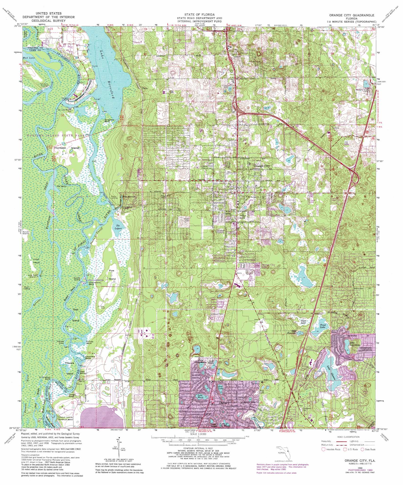
Orange City Topo Map Florida
To zoom in, hover over the map of Orange City
USGS Topo Quad 28081h3 - 1:24,000 scale
| Topo Map Name: | Orange City |
| USGS Topo Quad ID: | 28081h3 |
| Print Size: | ca. 21 1/4" wide x 27" high |
| Southeast Coordinates: | 28.875° N latitude / 81.25° W longitude |
| Map Center Coordinates: | 28.9375° N latitude / 81.3125° W longitude |
| U.S. State: | FL |
| Filename: | O28081H3.jpg |
| Download Map JPG Image: | Orange City topo map 1:24,000 scale |
| Map Type: | Topographic |
| Topo Series: | 7.5´ |
| Map Scale: | 1:24,000 |
| Source of Map Images: | United States Geological Survey (USGS) |
| Alternate Map Versions: |
Orange City FL 1964, updated 1965 Download PDF Buy paper map Orange City FL 1964, updated 1971 Download PDF Buy paper map Orange City FL 1964, updated 1972 Download PDF Buy paper map Orange City FL 1964, updated 1981 Download PDF Buy paper map Orange City FL 1964, updated 1984 Download PDF Buy paper map Orange City FL 2012 Download PDF Buy paper map Orange City FL 2015 Download PDF Buy paper map |
1:24,000 Topo Quads surrounding Orange City
Astor |
Pierson |
Lake Dias |
Daytona Beach Nw |
Daytona Beach |
Alexander Springs |
Lake Woodruff |
De Land |
Daytona Beach Sw |
Samsula |
Paisley |
Pine Lakes |
Orange City |
Lake Helen |
Lake Ashby |
Sorrento |
Sanford Sw |
Sanford |
Osteen |
Osceola |
Apopka |
Forest City |
Casselberry |
Oviedo |
Geneva |
> Back to 28081e1 at 1:100,000 scale
> Back to 28080a1 at 1:250,000 scale
> Back to U.S. Topo Maps home
Orange City topo map: Gazetteer
Orange City: Airports
Florida Hospital Fish Memorial Heliport elevation 12m 39′Orange City: Basins
The Basin elevation 1m 3′Orange City: Bays
Blue Springs Run elevation 0m 0′The Lagoon elevation 0m 0′
Volusia Cove elevation 1m 3′
Orange City: Bends
Beresford Bend elevation 1m 3′Carson Bend elevation 1m 3′
Coxetters Bend elevation 1m 3′
Dutchmans Bend elevation 1m 3′
Emanuel Bend elevation 3m 9′
Florida Bend elevation 1m 3′
North Emanuel Bend elevation 1m 3′
Wekiva Cutoff elevation 0m 0′
Orange City: Capes
Beresford Peninsula elevation 1m 3′Orange City: Channels
Barbers Reach elevation 0m 0′Happy Reach elevation 1m 3′
Snake Creek Cutoff elevation 0m 0′
Starks Cutoff elevation 0m 0′
Wekiva Beach elevation 0m 0′
Orange City: Guts
Banana River elevation 1m 3′Botts Creek elevation 0m 0′
Chub Slough elevation 1m 3′
Orange City: Islands
Flowers Island elevation 1m 3′Goat Island elevation 1m 3′
Guava Island elevation 1m 3′
Hontoon Island elevation 3m 9′
Live Oak Island elevation 2m 6′
Pine Island elevation 3m 9′
Scotts Island elevation 1m 3′
Scrub Island elevation 1m 3′
Orange City: Lakes
Angeles Lake elevation 7m 22′Bass Lake elevation 6m 19′
Bonita Lake elevation 8m 26′
Gem Lake elevation 10m 32′
Lago Lindo elevation 11m 36′
Lake Anna Marie elevation 14m 45′
Lake Beresford elevation 0m 0′
Lake Emerald elevation 6m 19′
Lake Gleason elevation 6m 19′
Lake Lapanocia elevation 7m 22′
Lake Marie elevation 18m 59′
Lake of the Woods elevation 11m 36′
Lake Susan elevation 11m 36′
Mud Lake elevation 0m 0′
The Lagoon elevation 0m 0′
Tropic Lagoon elevation 6m 19′
Trout Lake elevation 6m 19′
Orange City: Levees
High Banks elevation 2m 6′Orange City: Parks
Blue Spring State Park elevation 6m 19′De Land Marine Park elevation 1m 3′
Hontoon Island State Park elevation 2m 6′
Orange City: Populated Places
Blue Springs Landing elevation 4m 13′Candlelight Mobile Home Park elevation 20m 65′
Country Village Mobile Home Park elevation 15m 49′
DeBary elevation 22m 72′
Deltona elevation 9m 29′
Fatio elevation 5m 16′
Floriland Mobile Home Park elevation 23m 75′
Kings Lake Mobile Home Community elevation 9m 29′
Lakeside Mobile Home Park elevation 12m 39′
Lakeside Village Mobile Home Park elevation 12m 39′
Land O' Lakes Mobile Home Park elevation 20m 65′
Oak Hill Mobile Home Park elevation 9m 29′
Orange City elevation 10m 32′
Orange City Hills elevation 19m 62′
Orange City Mobile Home Park elevation 15m 49′
Orange Tree Village Mobile Home Park elevation 13m 42′
Pine Forest Mobile Home Park elevation 18m 59′
Riverside elevation 4m 13′
Riviera Mobile Home Park elevation 2m 6′
Sunset Mobile Home Park elevation 14m 45′
Orange City: Post Offices
Debary Post Office elevation 23m 75′Deltona Boulevard Post Office elevation 14m 45′
Orange City Post Office elevation 5m 16′
Orange City: Springs
Blue Springs elevation 14m 45′Orange City: Streams
Hontoon Dead River elevation 0m 0′Shell Creek elevation 0m 0′
Snake Creek elevation 0m 0′
Wekiva River elevation 0m 0′
Orange City: Swamps
Goose Lake elevation 6m 19′Indian Prairie elevation 1m 3′
Orange City digital topo map on disk
Buy this Orange City topo map showing relief, roads, GPS coordinates and other geographical features, as a high-resolution digital map file on DVD: