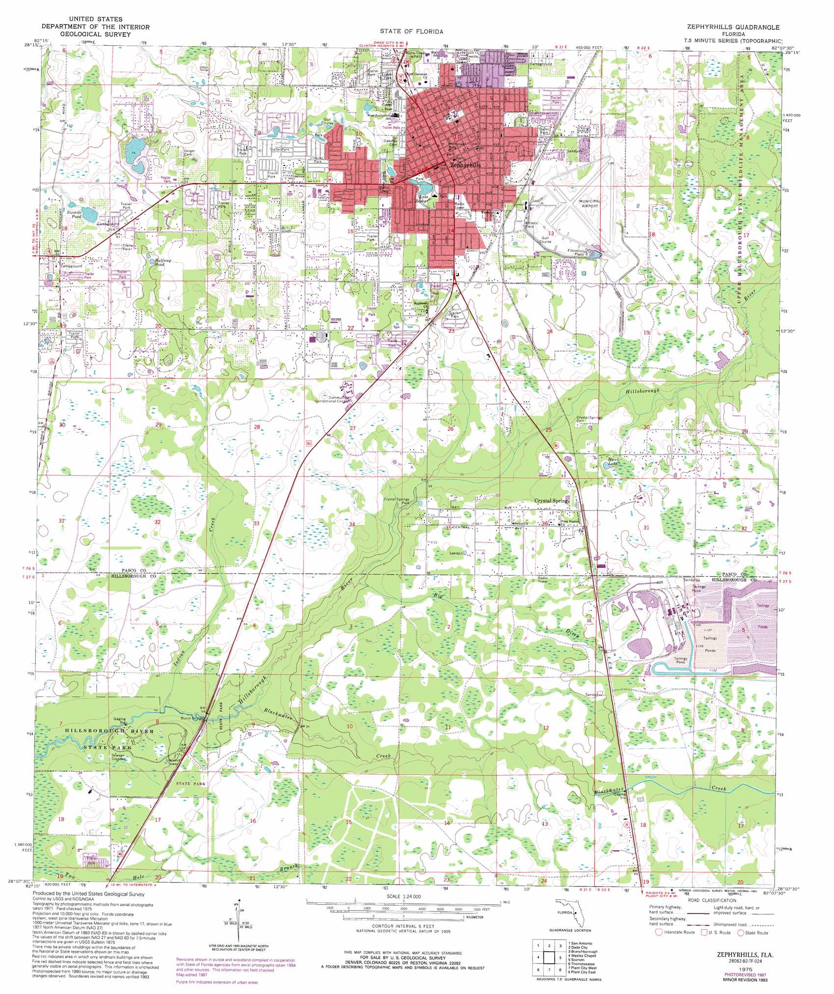
Zephyrhills Topo Map Florida
To zoom in, hover over the map of Zephyrhills
USGS Topo Quad 28082b2 - 1:24,000 scale
| Topo Map Name: | Zephyrhills |
| USGS Topo Quad ID: | 28082b2 |
| Print Size: | ca. 21 1/4" wide x 27" high |
| Southeast Coordinates: | 28.125° N latitude / 82.125° W longitude |
| Map Center Coordinates: | 28.1875° N latitude / 82.1875° W longitude |
| U.S. State: | FL |
| Filename: | O28082B2.jpg |
| Download Map JPG Image: | Zephyrhills topo map 1:24,000 scale |
| Map Type: | Topographic |
| Topo Series: | 7.5´ |
| Map Scale: | 1:24,000 |
| Source of Map Images: | United States Geological Survey (USGS) |
| Alternate Map Versions: |
Zephyrhills FL 1947 Download PDF Buy paper map Zephyrhills FL 1975, updated 1976 Download PDF Buy paper map Zephyrhills FL 1975, updated 1987 Download PDF Buy paper map Zephyrhills FL 1975, updated 1993 Download PDF Buy paper map Zephyrhills FL 2012 Download PDF Buy paper map Zephyrhills FL 2015 Download PDF Buy paper map |
1:24,000 Topo Quads surrounding Zephyrhills
Masaryktown |
Spring Lake |
Lacoochee |
Clay Sink |
Bay Lake |
Ehren |
San Antonio |
Dade City |
Branchborough |
Rock Ridge |
Lutz |
Wesley Chapel |
Zephyrhills |
Socrum |
Providence |
Sulphur Springs |
Thonotosassa |
Plant City West |
Plant City East |
Lakeland |
Tampa |
Brandon |
Dover |
Nichols |
Mulberry |
> Back to 28082a1 at 1:100,000 scale
> Back to 28082a1 at 1:250,000 scale
> Back to U.S. Topo Maps home
Zephyrhills topo map: Gazetteer
Zephyrhills: Airports
Blackwater Creek Ultralight Airport elevation 24m 78′Zephyrhills Municipal Airport elevation 26m 85′
Zephyrhills: Bridges
Burnt Bridge elevation 11m 36′Zephyrhills: Lakes
Halfway Pond elevation 22m 72′Hawk Lake elevation 21m 68′
Lake Bernadette elevation 24m 78′
Lake Zephyr elevation 22m 72′
Sixmile Pond elevation 24m 78′
Zephyrhills: Parks
Crystal Springs Park elevation 15m 49′Fort Foster State Historic Site elevation 13m 42′
Zephyrhills: Populated Places
Crystal Springs elevation 23m 75′Crystal Springs Colony Farms elevation 21m 68′
Davies Country Acres elevation 27m 88′
Zephyrhills elevation 29m 95′
Zephyrhills: Streams
Big Ditch elevation 13m 42′Blackwater Creek elevation 12m 39′
Indian Creek elevation 11m 36′
Two Hole Branch elevation 12m 39′
Zephyrhills digital topo map on disk
Buy this Zephyrhills topo map showing relief, roads, GPS coordinates and other geographical features, as a high-resolution digital map file on DVD: