Aripeka Topo Map Florida
To zoom in, hover over the map of Aripeka
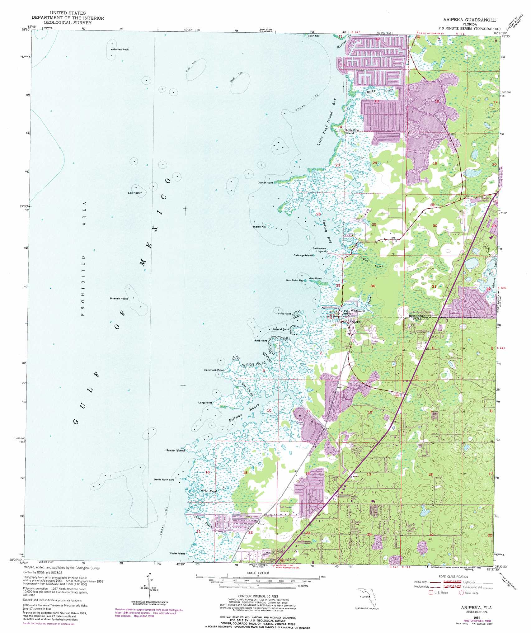
USGS Topo Quad 28082d6 - 1:24,000 scale
| Topo Map Name: | Aripeka |
| USGS Topo Quad ID: | 28082d6 |
| Print Size: | ca. 21 1/4" wide x 27" high |
| Southeast Coordinates: | 28.375° N latitude / 82.625° W longitude |
| Map Center Coordinates: | 28.4375° N latitude / 82.6875° W longitude |
| U.S. State: | FL |
| Filename: | O28082D6.jpg |
| Download Map JPG Image: | Aripeka topo map 1:24,000 scale |
| Map Type: | Topographic |
| Topo Series: | 7.5´ |
| Map Scale: | 1:24,000 |
| Source of Map Images: | United States Geological Survey (USGS) |
| Alternate Map Versions: |
Aripeka FL 1954, updated 1955 Download PDF Buy paper map Aripeka FL 1954, updated 1965 Download PDF Buy paper map Aripeka FL 1954, updated 1976 Download PDF Buy paper map Aripeka FL 2012 Download PDF Buy paper map Aripeka FL 2015 Download PDF Buy paper map |
1:24,000 Topo Quads surrounding Aripeka
Chassahowitzka Bay |
Chassahowitzka |
Brooksville Nw |
||
Bayport |
Weeki Wachee Spring |
Brooksville |
||
Aripeka |
Port Richey Ne |
Masaryktown |
||
Port Richey |
Fivay Junction |
Ehren |
||
Tarpon Springs |
Elfers |
Odessa |
Lutz |
> Back to 28082a1 at 1:100,000 scale
> Back to 28082a1 at 1:250,000 scale
> Back to U.S. Topo Maps home
Aripeka topo map: Gazetteer
Aripeka: Bays
Indian Bay elevation 0m 0′Little Pine Island Bay elevation 0m 0′
Aripeka: Beaches
Hernando Beach elevation 0m 0′Aripeka: Capes
Cedar Island elevation 0m 0′Dinner Point elevation 0m 0′
First Point elevation 0m 0′
Gun Point elevation 0m 0′
Hammock Point elevation 0m 0′
Long Point elevation 0m 0′
Second Point elevation 0m 0′
Third Point elevation 0m 0′
Aripeka: Channels
The Cutoff elevation 0m 0′Aripeka: Guts
Fillman Bayou elevation 0m 0′Rock Yard Creek elevation 0m 0′
Aripeka: Islands
Bathhouse Island elevation 0m 0′Bluefish Rocks elevation 0m 0′
Cabbage Island elevation 0m 0′
Devils Rock Yard elevation 0m 0′
Gomez Rock elevation 0m 0′
Gun Point Key elevation 0m 0′
Horse Island elevation 0m 0′
Indian Key elevation 0m 0′
Little Pine Island elevation 0m 0′
Low Rock elevation 0m 0′
Palm Island elevation 0m 0′
Aripeka: Populated Places
Aripeka elevation 1m 3′Hernando Beach elevation 1m 3′
Weekiwachee Gardens elevation 3m 9′
Aripeka: Streams
Ghost Creek elevation 0m 0′Hammock Creek elevation 0m 0′
Indian Creek elevation 0m 0′
Minnow Creek elevation 0m 0′
Rocky Creek elevation 0m 0′
Aripeka digital topo map on disk
Buy this Aripeka topo map showing relief, roads, GPS coordinates and other geographical features, as a high-resolution digital map file on DVD: