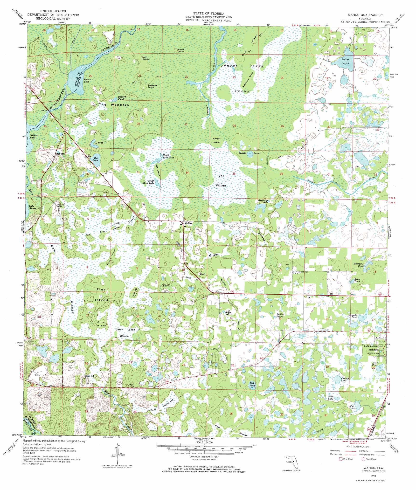
Wahoo Topo Map Florida
To zoom in, hover over the map of Wahoo
USGS Topo Quad 28082f2 - 1:24,000 scale
| Topo Map Name: | Wahoo |
| USGS Topo Quad ID: | 28082f2 |
| Print Size: | ca. 21 1/4" wide x 27" high |
| Southeast Coordinates: | 28.625° N latitude / 82.125° W longitude |
| Map Center Coordinates: | 28.6875° N latitude / 82.1875° W longitude |
| U.S. State: | FL |
| Filename: | O28082F2.jpg |
| Download Map JPG Image: | Wahoo topo map 1:24,000 scale |
| Map Type: | Topographic |
| Topo Series: | 7.5´ |
| Map Scale: | 1:24,000 |
| Source of Map Images: | United States Geological Survey (USGS) |
| Alternate Map Versions: |
Wahoo FL 1958, updated 1960 Download PDF Buy paper map Wahoo FL 1958, updated 1973 Download PDF Buy paper map Wahoo FL 2012 Download PDF Buy paper map Wahoo FL 2015 Download PDF Buy paper map |
1:24,000 Topo Quads surrounding Wahoo
Holder |
Stokes Ferry |
Lake Panasoffkee Nw |
Oxford |
Lady Lake |
Lecanto |
Inverness |
Rutland |
Wildwood |
Leesburg West |
Brooksville Nw |
Nobelton |
Wahoo |
Bushnell |
Center Hill |
Brooksville |
Brooksville Se |
Saint Catherine |
Webster |
Mascotte |
Masaryktown |
Spring Lake |
Lacoochee |
Clay Sink |
Bay Lake |
> Back to 28082e1 at 1:100,000 scale
> Back to 28082a1 at 1:250,000 scale
> Back to U.S. Topo Maps home
Wahoo topo map: Gazetteer
Wahoo: Basins
Hayes Sink elevation 16m 52′Wahoo: Canals
Beville Ditch elevation 19m 62′Wahoo: Flats
Buck Prairie elevation 13m 42′Wahoo: Guts
Bear Creek elevation 16m 52′Hayes Creek elevation 15m 49′
Wahoo: Islands
Bear Island elevation 13m 42′Bee Island elevation 13m 42′
Burnt Island elevation 13m 42′
Cabbage Island elevation 14m 45′
Cabbage Island elevation 13m 42′
Gun Tube Islands elevation 13m 42′
Jumper Island elevation 13m 42′
Millard Island elevation 15m 49′
Oliver Island elevation 14m 45′
Pine Island elevation 13m 42′
Soapstone Island elevation 13m 42′
Wahoo: Lakes
Baptizing Hole elevation 14m 45′Big Pond elevation 13m 42′
Bonnet Lake elevation 11m 36′
Deacon Pond elevation 13m 42′
Drawdy Pond elevation 20m 65′
Fish Pond elevation 17m 55′
Goose Pond elevation 21m 68′
Indian Prairie elevation 15m 49′
King Pond elevation 20m 65′
L Pond elevation 13m 42′
Little Pond elevation 12m 39′
Mud Lake elevation 19m 62′
Nelson Lake elevation 13m 42′
North Bear Lake elevation 13m 42′
Orange Lake elevation 19m 62′
Rock Lake elevation 19m 62′
Simmons Pond elevation 18m 59′
South Bear Lake elevation 13m 42′
Wahoo: Parks
Dade Battlefield Historic State Park elevation 21m 68′Wahoo: Populated Places
Bay Hill elevation 16m 52′Majestic Oaks Mobile Home Park elevation 20m 65′
Rosewood Mobile Home Park elevation 20m 65′
Wahoo elevation 15m 49′
Wynn Haven Mobile Home Park elevation 15m 49′
Wahoo: Streams
Gum Slough elevation 13m 42′Spring Run elevation 13m 42′
Wahoo: Swamps
Battle Slough elevation 13m 42′Buck Sawgrass elevation 14m 45′
Clabber Creek elevation 15m 49′
Grant Slough elevation 14m 45′
Jumper Creek Swamp elevation 13m 42′
The Willows elevation 13m 42′
The Wonders elevation 13m 42′
Wahoo: Woods
DeWitt Scrub elevation 13m 42′Wahoo digital topo map on disk
Buy this Wahoo topo map showing relief, roads, GPS coordinates and other geographical features, as a high-resolution digital map file on DVD: