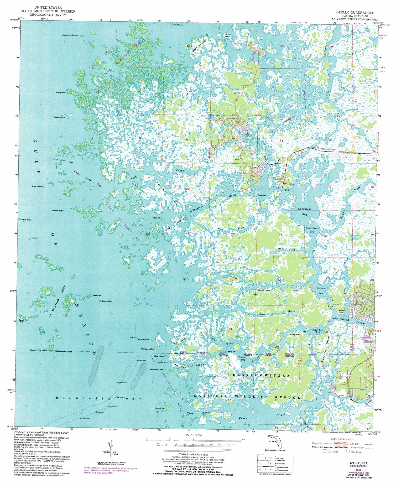
Ozello Topo Map Florida
To zoom in, hover over the map of Ozello
USGS Topo Quad 28082g6 - 1:24,000 scale
| Topo Map Name: | Ozello |
| USGS Topo Quad ID: | 28082g6 |
| Print Size: | ca. 21 1/4" wide x 27" high |
| Southeast Coordinates: | 28.75° N latitude / 82.625° W longitude |
| Map Center Coordinates: | 28.8125° N latitude / 82.6875° W longitude |
| U.S. State: | FL |
| Filename: | O28082G6.jpg |
| Download Map JPG Image: | Ozello topo map 1:24,000 scale |
| Map Type: | Topographic |
| Topo Series: | 7.5´ |
| Map Scale: | 1:24,000 |
| Source of Map Images: | United States Geological Survey (USGS) |
| Alternate Map Versions: |
Ozello FL 1954, updated 1955 Download PDF Buy paper map Ozello FL 1954, updated 1959 Download PDF Buy paper map Ozello FL 1954, updated 1972 Download PDF Buy paper map Ozello FL 1954, updated 1988 Download PDF Buy paper map Ozello FL 1954, updated 1992 Download PDF Buy paper map Ozello FL 1994, updated 1998 Download PDF Buy paper map Ozello FL 2012 Download PDF Buy paper map Ozello FL 2015 Download PDF Buy paper map |
1:24,000 Topo Quads surrounding Ozello
Withlacoochee Bay |
Yankeetown |
Yankeetown Se |
Dunnellon |
|
Red Level |
Crystal River |
Holder |
||
Ozello |
Homosassa |
Lecanto |
||
Chassahowitzka Bay |
Chassahowitzka |
Brooksville Nw |
||
Bayport |
Weeki Wachee Spring |
Brooksville |
> Back to 28082e1 at 1:100,000 scale
> Back to 28082a1 at 1:250,000 scale
> Back to U.S. Topo Maps home
Ozello topo map: Gazetteer
Ozello: Bays
Fish Creek Bay elevation 0m 0′Game Creek Bay elevation 0m 0′
Greenleaf Bay elevation 0m 0′
Gustaf Bay elevation 0m 0′
Hell Gate elevation 0m 0′
Shivers Bay elevation 0m 0′
Tiger Tail Bay elevation 0m 0′
Ozello: Capes
Coffin Point elevation 0m 0′Green Point elevation 0m 0′
Homosassa Point elevation 0m 0′
Lashley Point elevation 0m 0′
Long Point elevation 0m 0′
Mangrove Point elevation 0m 0′
South Point elevation 0m 0′
Willey Point elevation 0m 0′
Ozello: Channels
Grey Mare Pass elevation 0m 0′North Channel elevation 0m 0′
Ozello: Guts
Battle Creek elevation 0m 0′Black Creek elevation 0m 0′
Deep Creek elevation 0m 0′
False Channel elevation 0m 0′
Fish Creek elevation 0m 0′
Fish Creek Pass elevation 0m 0′
Head Creek elevation 0m 0′
Little Homosassa River elevation 0m 0′
Pea Pass elevation 0m 0′
Petty Creek elevation 0m 0′
Saint Martins River elevation 0m 0′
Salt River elevation 0m 0′
Sams Bayou elevation 0m 0′
The Narrows elevation 0m 0′
Ozello: Islands
Bear Island elevation 0m 0′Beli Island elevation 0m 0′
Bird Keys elevation 0m 0′
Charr Island elevation 0m 0′
Crawl Key elevation 0m 0′
Dog Island elevation 0m 0′
Dog Island elevation 0m 0′
Green Key elevation 0m 0′
Greenleaf Key elevation 0m 0′
Mendit Key elevation 0m 0′
Paradise Island elevation 0m 0′
Pipe Island elevation 0m 0′
Pompano Key elevation 0m 0′
Roach Key elevation 0m 0′
Rock Island elevation 0m 0′
Saint Martins Keys elevation 0m 0′
Sand Key elevation 0m 0′
Shell Island elevation 0m 0′
Ship Rock elevation 0m 0′
The Suncoast Keys elevation 0m 0′
Tiger Tail Island elevation 0m 0′
Ozello: Parks
Saint Martins Marsh Aquatic Preserve elevation 0m 0′Ozello: Populated Places
Ozello elevation 0m 0′Ozello: Streams
Game Creek elevation 0m 0′Homosassa River elevation 0m 0′
Mason Creek elevation 0m 0′
Mud Creek elevation 0m 0′
Price Creek elevation 0m 0′
Salt Creek elevation 0m 0′
Ozello digital topo map on disk
Buy this Ozello topo map showing relief, roads, GPS coordinates and other geographical features, as a high-resolution digital map file on DVD: