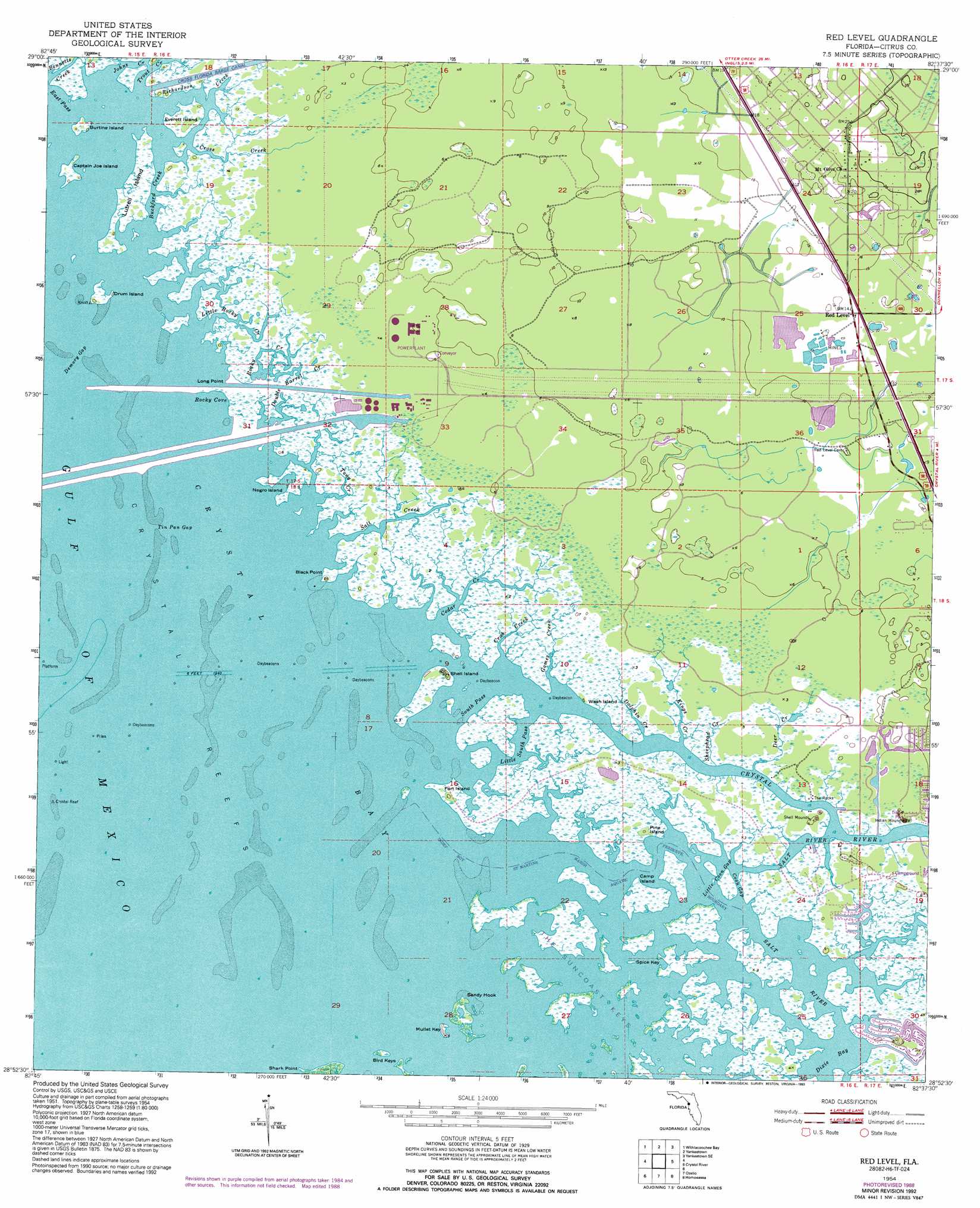
Red Level Topo Map Florida
To zoom in, hover over the map of Red Level
USGS Topo Quad 28082h6 - 1:24,000 scale
| Topo Map Name: | Red Level |
| USGS Topo Quad ID: | 28082h6 |
| Print Size: | ca. 21 1/4" wide x 27" high |
| Southeast Coordinates: | 28.875° N latitude / 82.625° W longitude |
| Map Center Coordinates: | 28.9375° N latitude / 82.6875° W longitude |
| U.S. State: | FL |
| Filename: | O28082H6.jpg |
| Download Map JPG Image: | Red Level topo map 1:24,000 scale |
| Map Type: | Topographic |
| Topo Series: | 7.5´ |
| Map Scale: | 1:24,000 |
| Source of Map Images: | United States Geological Survey (USGS) |
| Alternate Map Versions: |
Red Level FL 1954, updated 1955 Download PDF Buy paper map Red Level FL 1954, updated 1964 Download PDF Buy paper map Red Level FL 1954, updated 1964 Download PDF Buy paper map Red Level FL 1954, updated 1988 Download PDF Buy paper map Red Level FL 1954, updated 1993 Download PDF Buy paper map Red Level FL 2012 Download PDF Buy paper map Red Level FL 2015 Download PDF Buy paper map |
1:24,000 Topo Quads surrounding Red Level
Sumner |
Waccasassa Bay |
Lebanon Station |
Tidewater |
Romeo |
Withlacoochee Bay |
Yankeetown |
Yankeetown Se |
Dunnellon |
|
Red Level |
Crystal River |
Holder |
||
Ozello |
Homosassa |
Lecanto |
||
Chassahowitzka Bay |
Chassahowitzka |
Brooksville Nw |
> Back to 28082e1 at 1:100,000 scale
> Back to 28082a1 at 1:250,000 scale
> Back to U.S. Topo Maps home
Red Level topo map: Gazetteer
Red Level: Bars
Crystal Reef elevation 0m 0′Red Level: Bays
Crystal Bay elevation 0m 0′Dixie Bay elevation 0m 0′
Rocky Cove elevation 0m 0′
Red Level: Beaches
Fort Island Beach elevation 1m 3′Red Level: Capes
Black Point elevation 1m 3′Long Point elevation 1m 3′
Sandy Hook elevation 1m 3′
Shark Point elevation 1m 3′
Red Level: Channels
Demory Gap elevation 0m 0′East Pass elevation 0m 0′
South Pass elevation 0m 0′
Tin Pan Gap elevation 0m 0′
Red Level: Guts
Buckford Creek elevation 0m 0′Coon Gap elevation 0m 0′
Little Coon Gap elevation 0m 0′
Little South Pass elevation 0m 0′
Tony Creek elevation 0m 0′
Red Level: Islands
Big Grass Island elevation 0m 0′Bird Keys elevation 1m 3′
Burtine Island elevation 1m 3′
Camp Island elevation 1m 3′
Captain Joe Island elevation 1m 3′
Drum Island elevation 1m 3′
Everett Island elevation 1m 3′
Fort Island elevation 1m 3′
Lutrell Island elevation 1m 3′
Mullet Key elevation 1m 3′
Needle Grass Island elevation 1m 3′
Negro Island elevation 1m 3′
Pine Island elevation 1m 3′
Rocky Island elevation 0m 0′
Shell Island elevation 1m 3′
Snake Island elevation 1m 3′
Spice Key elevation 1m 3′
Wash Island elevation 1m 3′
Red Level: Parks
Crystal River Historic Memorial elevation 1m 3′Crystal River State Archaeological Site elevation 1m 3′
Red Level: Populated Places
Red Level elevation 4m 13′Red Level: Streams
Bennetts Creek elevation 0m 0′Cedar Creek elevation 0m 0′
Crab Creek elevation 0m 0′
Cross Creek elevation 0m 0′
Crystal River elevation 0m 0′
Deer Creek elevation 0m 0′
Dolphin Creek elevation 1m 3′
Double Barrel Creek elevation 0m 0′
Gomez Creek elevation 0m 0′
Johns Creek elevation 0m 0′
Kings Creek elevation 0m 0′
Little Rocky Creek elevation 0m 0′
Richardson Creek elevation 0m 0′
Rocky Creek elevation 0m 0′
Salt Creek elevation 0m 0′
Sheephead Creek elevation 1m 3′
Trout Creek elevation 0m 0′
Red Level: Trails
West Fort Island Trail elevation 1m 3′Red Level digital topo map on disk
Buy this Red Level topo map showing relief, roads, GPS coordinates and other geographical features, as a high-resolution digital map file on DVD: