Port O'Connor Topo Map Texas
To zoom in, hover over the map of Port O'Connor
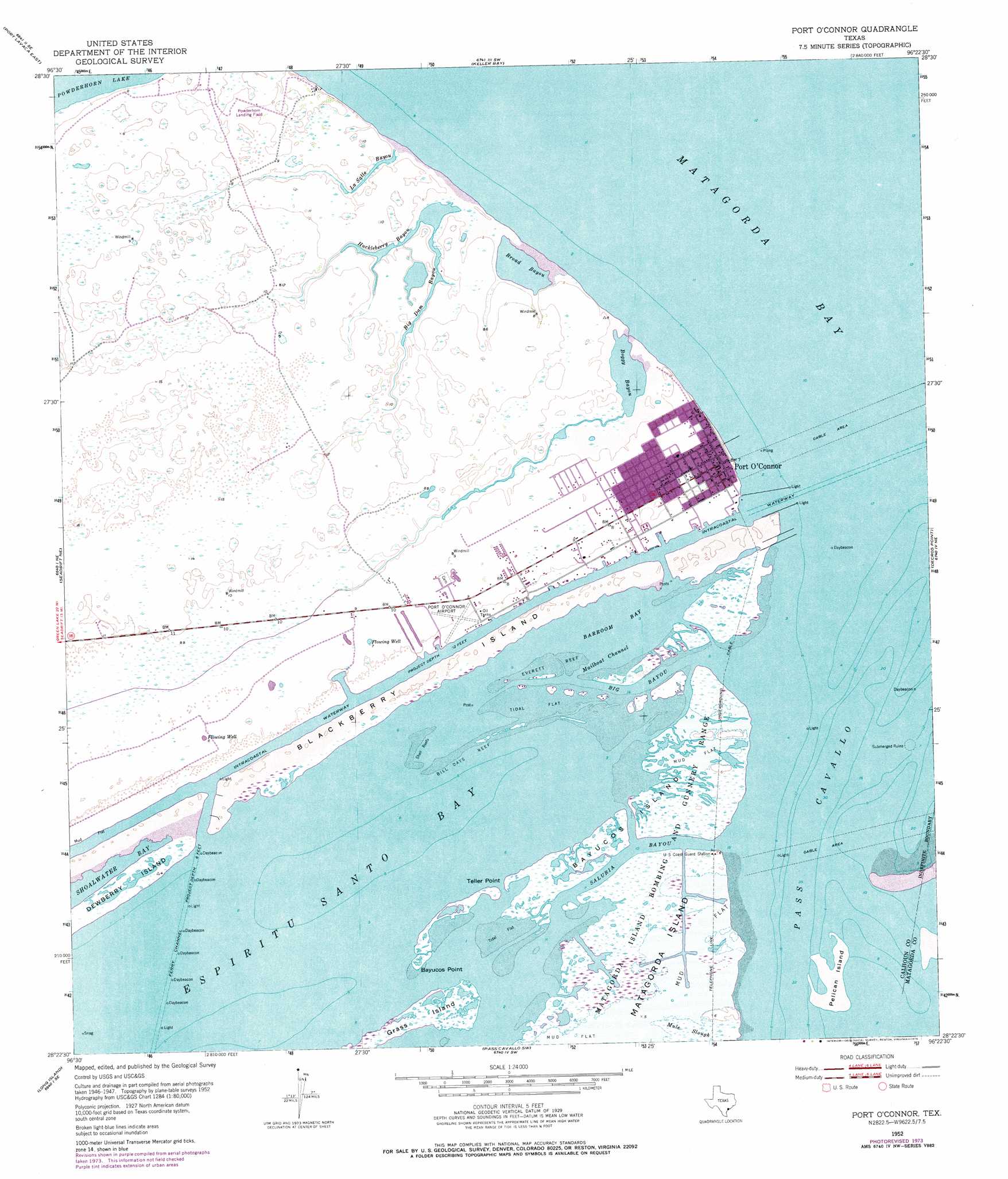
USGS Topo Quad 28096d4 - 1:24,000 scale
| Topo Map Name: | Port O'Connor |
| USGS Topo Quad ID: | 28096d4 |
| Print Size: | ca. 21 1/4" wide x 27" high |
| Southeast Coordinates: | 28.375° N latitude / 96.375° W longitude |
| Map Center Coordinates: | 28.4375° N latitude / 96.4375° W longitude |
| U.S. State: | TX |
| Filename: | o28096d4.jpg |
| Download Map JPG Image: | Port O'Connor topo map 1:24,000 scale |
| Map Type: | Topographic |
| Topo Series: | 7.5´ |
| Map Scale: | 1:24,000 |
| Source of Map Images: | United States Geological Survey (USGS) |
| Alternate Map Versions: |
Port O'Connor TX 1952, updated 1954 Download PDF Buy paper map Port O'Connor TX 1952, updated 1973 Download PDF Buy paper map Port O'Connor TX 1952, updated 1976 Download PDF Buy paper map Port O'Connor TX 2010 Download PDF Buy paper map Port O'Connor TX 2013 Download PDF Buy paper map Port O'Connor TX 2016 Download PDF Buy paper map |
1:24,000 Topo Quads surrounding Port O'Connor
Kamey |
Point Comfort |
Olivia |
Turtle Bay |
Palacios |
Port Lavaca West |
Port Lavaca East |
Keller Bay |
Carancahua Pass |
Palacios Point |
Seadrift |
Seadrift Ne |
Port O'Connor |
Decros Point |
South Of Palacios Point |
Mosquito Point |
Long Island |
Pass Cavallo Sw |
||
Panther Point |
Panther Point Ne |
> Back to 28096a1 at 1:100,000 scale
> Back to 28096a1 at 1:250,000 scale
> Back to U.S. Topo Maps home
Port O'Connor topo map: Gazetteer
Port O'Connor: Airports
HHI-Port O'Connor Heliport elevation 2m 6′Phi Heliport elevation 2m 6′
Port O'Connor Airport elevation 1m 3′
Port O'Connor Base elevation 3m 9′
Port O'Connor: Bars
Bill Days Reef elevation 0m 0′Everett Reef elevation 0m 0′
Port O'Connor: Bays
Barroom Bay elevation 0m 0′Whitakers Bayou elevation 0m 0′
Port O'Connor: Capes
Bayucos Point elevation 1m 3′Mailboat Point elevation 1m 3′
Teller Point elevation 1m 3′
Port O'Connor: Channels
Fishermans Cut elevation 0m 0′Little Marys Cut elevation 0m 0′
Mailboat Channel elevation 0m 0′
Mitchells Cut elevation 0m 0′
Pass Cavallo elevation 1m 3′
Port O'Connor: Guts
Big Bayou elevation 0m 0′Big Dam Bayou elevation 1m 3′
Boggy Bayou elevation 0m 0′
Broad Bayou elevation 0m 0′
Fishermans Cut elevation 0m 0′
Huckleberry Bayou elevation 1m 3′
LaSalle Bayou elevation 1m 3′
Little Marys Cut elevation 1m 3′
Mitchells Cut elevation 0m 0′
Mule Slough elevation 1m 3′
Saluria Bayou elevation 0m 0′
Port O'Connor: Islands
Bayucos Island elevation 1m 3′Blackberry Island elevation 1m 3′
Grass Island elevation 1m 3′
Pelican Island elevation 1m 3′
Port O'Connor: Populated Places
Port O'Connor elevation 1m 3′Port O'Connor: Swamps
Live Oaks Bayou elevation 1m 3′Port O'Connor digital topo map on disk
Buy this Port O'Connor topo map showing relief, roads, GPS coordinates and other geographical features, as a high-resolution digital map file on DVD: