Bloomington Sw Topo Map Texas
To zoom in, hover over the map of Bloomington Sw
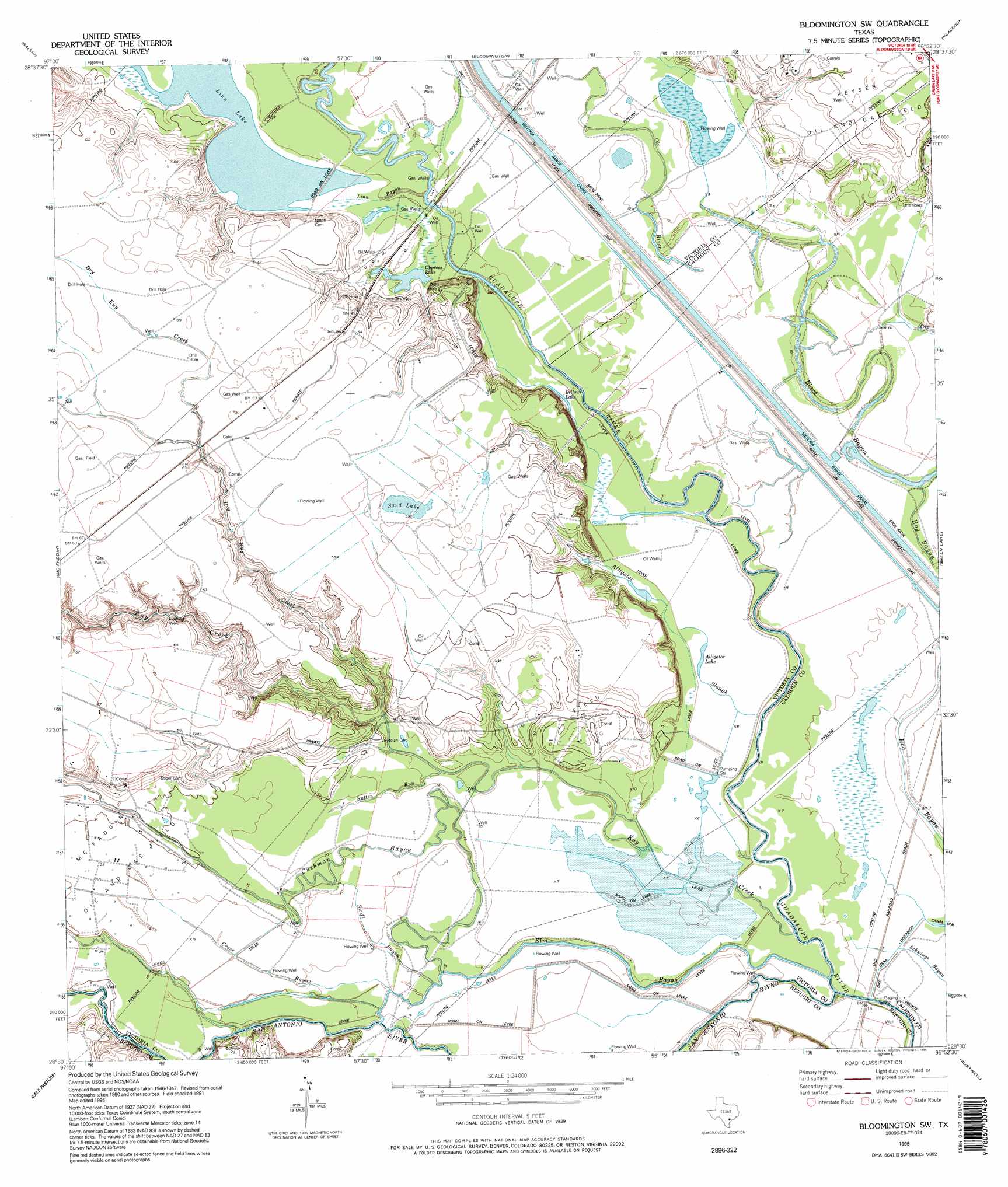
USGS Topo Quad 28096e8 - 1:24,000 scale
| Topo Map Name: | Bloomington Sw |
| USGS Topo Quad ID: | 28096e8 |
| Print Size: | ca. 21 1/4" wide x 27" high |
| Southeast Coordinates: | 28.5° N latitude / 96.875° W longitude |
| Map Center Coordinates: | 28.5625° N latitude / 96.9375° W longitude |
| U.S. State: | TX |
| Filename: | o28096e8.jpg |
| Download Map JPG Image: | Bloomington Sw topo map 1:24,000 scale |
| Map Type: | Topographic |
| Topo Series: | 7.5´ |
| Map Scale: | 1:24,000 |
| Source of Map Images: | United States Geological Survey (USGS) |
| Alternate Map Versions: |
Bloomington SW TX 1952, updated 1953 Download PDF Buy paper map Bloomington SW TX 1952, updated 1970 Download PDF Buy paper map Bloomington SW TX 1952, updated 1974 Download PDF Buy paper map Bloomington SW TX 1952, updated 1976 Download PDF Buy paper map Bloomington SW TX 1995, updated 1995 Download PDF Buy paper map Bloomington SW TX 2010 Download PDF Buy paper map Bloomington SW TX 2013 Download PDF Buy paper map Bloomington SW TX 2016 Download PDF Buy paper map |
1:24,000 Topo Quads surrounding Bloomington Sw
Schroeder |
Victoria West |
Victoria East |
Marcado Creek |
La Salle |
Fannin |
Raisin |
Bloomington |
Placedo |
Kamey |
Lott Lake |
Mcfaddin |
Bloomington Sw |
Green Lake |
Port Lavaca West |
Vidaurri |
Lake Pasture |
Tivoli |
Austwell |
Seadrift |
Quintana |
Twin Mott Lake |
Tivoli Sw |
Tivoli Se |
Mosquito Point |
> Back to 28096e1 at 1:100,000 scale
> Back to 28096a1 at 1:250,000 scale
> Back to U.S. Topo Maps home
Bloomington Sw topo map: Gazetteer
Bloomington Sw: Dams
Station 1888 Dam elevation 1m 3′Bloomington Sw: Guts
Elm Bayou elevation 2m 6′Old River elevation 3m 9′
Bloomington Sw: Lakes
Linn Lake elevation 4m 13′Sand Lake elevation 18m 59′
Bloomington Sw: Streams
Black Bayou elevation 4m 13′Cross Bayou elevation 3m 9′
Cushman Bayou elevation 3m 9′
Dry Kuy Creek elevation 3m 9′
Kuy Creek elevation 1m 3′
San Antonio River elevation 1m 3′
Swift Bayou elevation 3m 9′
Bloomington Sw digital topo map on disk
Buy this Bloomington Sw topo map showing relief, roads, GPS coordinates and other geographical features, as a high-resolution digital map file on DVD: