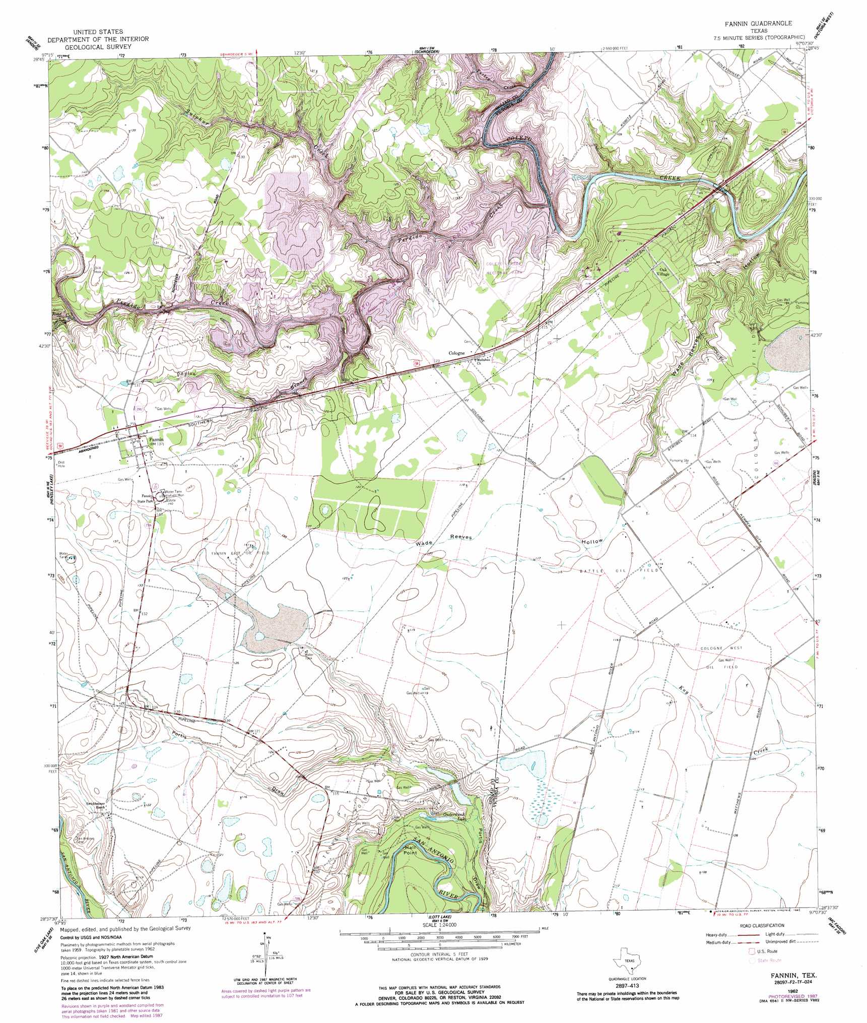
Fannin Topo Map Texas
To zoom in, hover over the map of Fannin
USGS Topo Quad 28097f2 - 1:24,000 scale
| Topo Map Name: | Fannin |
| USGS Topo Quad ID: | 28097f2 |
| Print Size: | ca. 21 1/4" wide x 27" high |
| Southeast Coordinates: | 28.625° N latitude / 97.125° W longitude |
| Map Center Coordinates: | 28.6875° N latitude / 97.1875° W longitude |
| U.S. State: | TX |
| Filename: | o28097f2.jpg |
| Download Map JPG Image: | Fannin topo map 1:24,000 scale |
| Map Type: | Topographic |
| Topo Series: | 7.5´ |
| Map Scale: | 1:24,000 |
| Source of Map Images: | United States Geological Survey (USGS) |
| Alternate Map Versions: |
Fannin TX 1962, updated 1963 Download PDF Buy paper map Fannin TX 1962, updated 1987 Download PDF Buy paper map Fannin TX 2010 Download PDF Buy paper map Fannin TX 2013 Download PDF Buy paper map Fannin TX 2016 Download PDF Buy paper map |
1:24,000 Topo Quads surrounding Fannin
Yorktown East |
Meyersville |
Mission Valley |
Nursery |
Inez Nw |
Weesatche |
Ander |
Schroeder |
Victoria West |
Victoria East |
Goliad |
Hensley Lake |
Fannin |
Raisin |
Bloomington |
Melo |
Live Oak Lake |
Lott Lake |
Mcfaddin |
Bloomington Sw |
Blanconia |
Ryanville |
Vidaurri |
Lake Pasture |
Tivoli |
> Back to 28097e1 at 1:100,000 scale
> Back to 28096a1 at 1:250,000 scale
> Back to U.S. Topo Maps home
Fannin topo map: Gazetteer
Fannin: Capes
Hall Point elevation 24m 78′Fannin: Dams
Coleto Creek Dam elevation 30m 98′Fannin: Lakes
Onderdunk Lake elevation 23m 75′Fannin: Oilfields
Battle Oil Field elevation 35m 114′Cologne West Oil Field elevation 33m 108′
Fannin East Oil Field elevation 42m 137′
Terrell Point Oil Field elevation 35m 114′
Fannin: Parks
Coleto Creek Regional Park elevation 33m 108′Fannin State Park elevation 43m 141′
Fannin: Populated Places
Cologne elevation 37m 121′Fannin elevation 43m 141′
Oak Village elevation 35m 114′
Fannin: Reservoirs
Coleto Creek Cooling Pond elevation 30m 98′Fannin: Streams
Payton Branch elevation 30m 98′Perdido Creek elevation 30m 98′
Road Creek elevation 30m 98′
Sulphur Creek elevation 30m 98′
Turkey Creek elevation 30m 98′
Fannin: Valleys
Portis Draw elevation 22m 72′Portis Draw elevation 25m 82′
Sand Hollow elevation 32m 104′
Wade Reeves Hollow elevation 17m 55′
Fannin digital topo map on disk
Buy this Fannin topo map showing relief, roads, GPS coordinates and other geographical features, as a high-resolution digital map file on DVD: