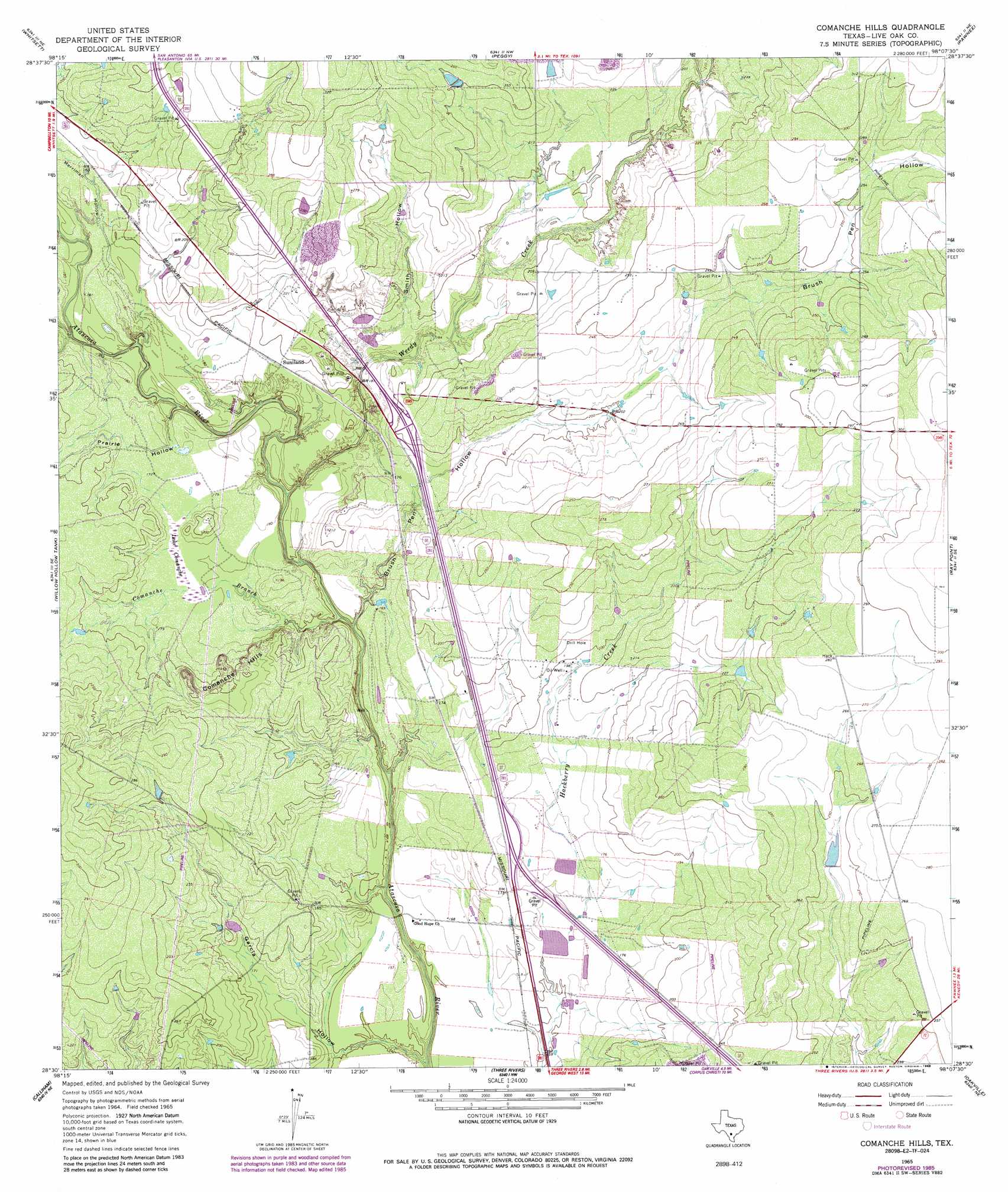
Comanche Hills Topo Map Texas
To zoom in, hover over the map of Comanche Hills
USGS Topo Quad 28098e2 - 1:24,000 scale
| Topo Map Name: | Comanche Hills |
| USGS Topo Quad ID: | 28098e2 |
| Print Size: | ca. 21 1/4" wide x 27" high |
| Southeast Coordinates: | 28.5° N latitude / 98.125° W longitude |
| Map Center Coordinates: | 28.5625° N latitude / 98.1875° W longitude |
| U.S. State: | TX |
| Filename: | o28098e2.jpg |
| Download Map JPG Image: | Comanche Hills topo map 1:24,000 scale |
| Map Type: | Topographic |
| Topo Series: | 7.5´ |
| Map Scale: | 1:24,000 |
| Source of Map Images: | United States Geological Survey (USGS) |
| Alternate Map Versions: |
Comanche Hills TX 1965, updated 1968 Download PDF Buy paper map Comanche Hills TX 1965, updated 1986 Download PDF Buy paper map Comanche Hills TX 2010 Download PDF Buy paper map Comanche Hills TX 2012 Download PDF Buy paper map Comanche Hills TX 2016 Download PDF Buy paper map |
1:24,000 Topo Quads surrounding Comanche Hills
Christine East |
Mccoy |
Fashing |
Coy City |
Lenz |
Caballos Creek |
Whitsett |
Peggy |
Pawnee |
Monteola |
Crowther |
Willow Hollow Tank |
Comanche Hills |
Ray Point |
Mineral |
Calliham Nw |
Calliham |
Three Rivers |
Oakville |
Cadiz |
San Caja Hill |
Live Oak Hollow |
Oakville Sw |
George West |
Mulos Hills |
> Back to 28098e1 at 1:100,000 scale
> Back to 28098a1 at 1:250,000 scale
> Back to U.S. Topo Maps home
Comanche Hills topo map: Gazetteer
Comanche Hills: Dams
House Lake Dam elevation 68m 223′Comanche Hills: Lakes
Lake Comanche elevation 52m 170′Comanche Hills: Reservoirs
House Lake elevation 68m 223′Comanche Hills: Streams
Comanche Branch elevation 40m 131′Weedy Creek elevation 42m 137′
Comanche Hills: Summits
Comanche Hills elevation 75m 246′Comanche Hills: Valleys
Brush Pen Hollow elevation 44m 144′Garcia Hollow elevation 39m 127′
Merriman Hollow elevation 46m 150′
Prairie Hollow elevation 45m 147′
Smith Hollow elevation 59m 193′
Comanche Hills digital topo map on disk
Buy this Comanche Hills topo map showing relief, roads, GPS coordinates and other geographical features, as a high-resolution digital map file on DVD: