Peggy Topo Map Texas
To zoom in, hover over the map of Peggy
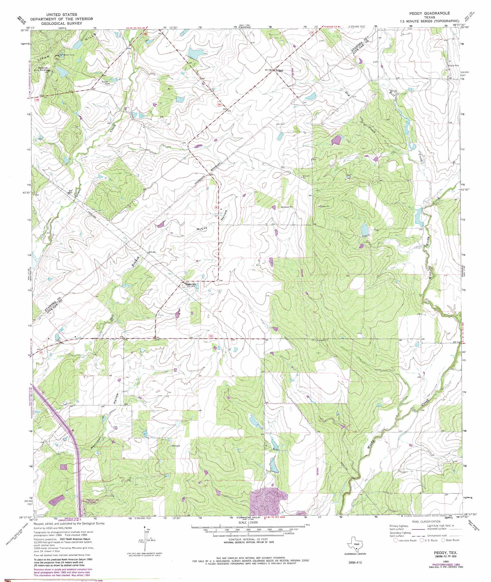
USGS Topo Quad 28098f2 - 1:24,000 scale
| Topo Map Name: | Peggy |
| USGS Topo Quad ID: | 28098f2 |
| Print Size: | ca. 21 1/4" wide x 27" high |
| Southeast Coordinates: | 28.625° N latitude / 98.125° W longitude |
| Map Center Coordinates: | 28.6875° N latitude / 98.1875° W longitude |
| U.S. State: | TX |
| Filename: | o28098f2.jpg |
| Download Map JPG Image: | Peggy topo map 1:24,000 scale |
| Map Type: | Topographic |
| Topo Series: | 7.5´ |
| Map Scale: | 1:24,000 |
| Source of Map Images: | United States Geological Survey (USGS) |
| Alternate Map Versions: |
Peggy TX 1965, updated 1969 Download PDF Buy paper map Peggy TX 1965, updated 1986 Download PDF Buy paper map Peggy TX 2010 Download PDF Buy paper map Peggy TX 2012 Download PDF Buy paper map Peggy TX 2016 Download PDF Buy paper map |
1:24,000 Topo Quads surrounding Peggy
Pleasanton |
Leal |
Three Oaks |
Falls City |
Karnes City |
Christine East |
Mccoy |
Fashing |
Coy City |
Lenz |
Caballos Creek |
Whitsett |
Peggy |
Pawnee |
Monteola |
Crowther |
Willow Hollow Tank |
Comanche Hills |
Ray Point |
Mineral |
Calliham Nw |
Calliham |
Three Rivers |
Oakville |
Cadiz |
> Back to 28098e1 at 1:100,000 scale
> Back to 28098a1 at 1:250,000 scale
> Back to U.S. Topo Maps home
Peggy topo map: Gazetteer
Peggy: Dams
Esse Lake Number 7 Dam elevation 97m 318′Esse Lake Number 8 Dam elevation 103m 337′
James Esse Lake Dam elevation 83m 272′
Lillian Esse Lake Dam elevation 89m 291′
Smith Dam 2 elevation 101m 331′
Smith Dam Number 1 elevation 113m 370′
Taylor Lake Number 1 Dam elevation 84m 275′
Taylor Lake Number 2 Dam elevation 79m 259′
Taylor Lake Number 3 Dam elevation 76m 249′
Peggy: Populated Places
Esseville elevation 107m 351′Peggy elevation 116m 380′
Peggy: Reservoirs
Esse Lake Number 7 elevation 97m 318′Esse Lake Number 8 elevation 103m 337′
James Esse Lake elevation 83m 272′
Lake Number 1 elevation 113m 370′
Lake Number 2 elevation 101m 331′
Lillian Esse Lake elevation 89m 291′
Taylor Lake Number 1 elevation 84m 275′
Taylor Lake Number 2 elevation 79m 259′
Taylor Lake Number 3 elevation 76m 249′
Peggy: Streams
Bell Creek elevation 79m 259′Dry Creek elevation 84m 275′
West Weedy Creek elevation 79m 259′
Peggy: Summits
Lipan Hills elevation 110m 360′Peggy: Valleys
McCoy Hollow elevation 88m 288′Peggy digital topo map on disk
Buy this Peggy topo map showing relief, roads, GPS coordinates and other geographical features, as a high-resolution digital map file on DVD: