Carrizo Springs East Topo Map Texas
To zoom in, hover over the map of Carrizo Springs East
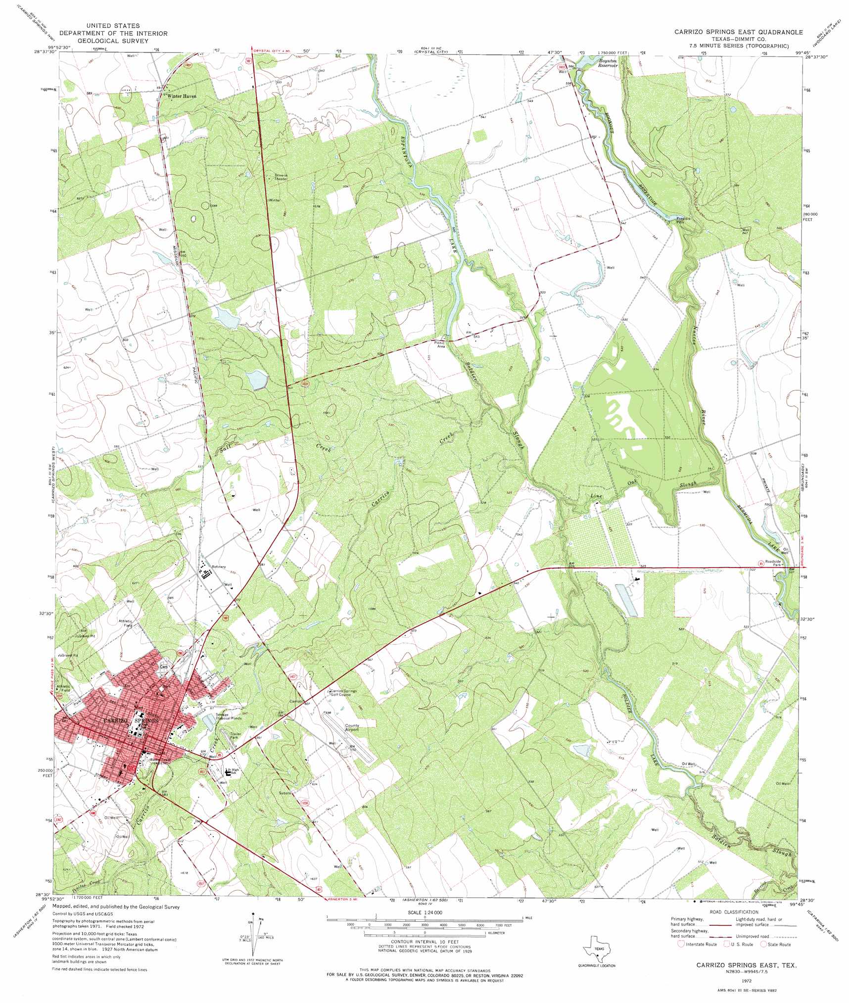
USGS Topo Quad 28099e7 - 1:24,000 scale
| Topo Map Name: | Carrizo Springs East |
| USGS Topo Quad ID: | 28099e7 |
| Print Size: | ca. 21 1/4" wide x 27" high |
| Southeast Coordinates: | 28.5° N latitude / 99.75° W longitude |
| Map Center Coordinates: | 28.5625° N latitude / 99.8125° W longitude |
| U.S. State: | TX |
| Filename: | o28099e7.jpg |
| Download Map JPG Image: | Carrizo Springs East topo map 1:24,000 scale |
| Map Type: | Topographic |
| Topo Series: | 7.5´ |
| Map Scale: | 1:24,000 |
| Source of Map Images: | United States Geological Survey (USGS) |
| Alternate Map Versions: |
Carrizo Springs East TX 1972, updated 1975 Download PDF Buy paper map Carrizo Springs East TX 2010 Download PDF Buy paper map Carrizo Springs East TX 2013 Download PDF Buy paper map Carrizo Springs East TX 2016 Download PDF Buy paper map |
1:24,000 Topo Quads surrounding Carrizo Springs East
Chacon Creek Se |
Beef Hollow Creek |
La Pryor Se |
Batesville Sw |
Loma Vista |
Cometa |
Carrizo Springs Nw |
Crystal City |
Woodard Lake |
Sugar Creek |
Cayetano Creek |
Carrizo Springs West |
Carrizo Springs East |
Brundage |
Big Wells |
Palo Blanco Tank |
Asherton Nw |
Asherton |
Macdonald Lake |
Valley Wells |
San Pedro Creek |
Dentonio |
Farias Tank |
Dabney Tank |
Catarina |
> Back to 28099e1 at 1:100,000 scale
> Back to 28098a1 at 1:250,000 scale
> Back to U.S. Topo Maps home
Carrizo Springs East topo map: Gazetteer
Carrizo Springs East: Airports
Dimmit County Airport elevation 179m 587′Carrizo Springs East: Dams
Allen North Lake Dam elevation 171m 561′Allen South Lake Dam elevation 167m 547′
Bookout Dam elevation 160m 524′
Boynton Dam elevation 168m 551′
Espantosa Dam elevation 162m 531′
Carrizo Springs East: Lakes
Soldier Lake elevation 156m 511′Carrizo Springs East: Parks
Presidio Park elevation 165m 541′Carrizo Springs East: Populated Places
Carrizo Hill elevation 192m 629′Carrizo Hills Colonia elevation 191m 626′
Carrizo Springs elevation 184m 603′
Winter Haven elevation 180m 590′
Carrizo Springs East: Reservoirs
Allen North Lake elevation 171m 561′Allen South Lake elevation 167m 547′
Bookout Lake elevation 160m 524′
Bookout Reservoir elevation 164m 538′
Boynton Lake elevation 168m 551′
Espantosa Lake elevation 161m 528′
Carrizo Springs East: Streams
Carrizo Creek elevation 159m 521′Line Oak Slough elevation 155m 508′
Peñitas Creek elevation 177m 580′
Salt Creek elevation 159m 521′
Carrizo Springs East digital topo map on disk
Buy this Carrizo Springs East topo map showing relief, roads, GPS coordinates and other geographical features, as a high-resolution digital map file on DVD: