Pearsall North Topo Map Texas
To zoom in, hover over the map of Pearsall North
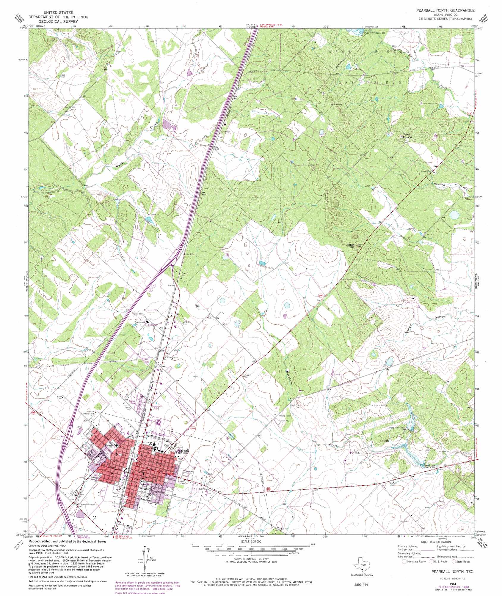
USGS Topo Quad 28099h1 - 1:24,000 scale
| Topo Map Name: | Pearsall North |
| USGS Topo Quad ID: | 28099h1 |
| Print Size: | ca. 21 1/4" wide x 27" high |
| Southeast Coordinates: | 28.875° N latitude / 99° W longitude |
| Map Center Coordinates: | 28.9375° N latitude / 99.0625° W longitude |
| U.S. State: | TX |
| Filename: | o28099h1.jpg |
| Download Map JPG Image: | Pearsall North topo map 1:24,000 scale |
| Map Type: | Topographic |
| Topo Series: | 7.5´ |
| Map Scale: | 1:24,000 |
| Source of Map Images: | United States Geological Survey (USGS) |
| Alternate Map Versions: |
Pearsall North TX 1964, updated 1966 Download PDF Buy paper map Pearsall North TX 1964, updated 1982 Download PDF Buy paper map Pearsall North TX 2010 Download PDF Buy paper map Pearsall North TX 2013 Download PDF Buy paper map Pearsall North TX 2016 Download PDF Buy paper map |
1:24,000 Topo Quads surrounding Pearsall North
Frio Town Ne |
Yancey |
Biry |
Devine |
Lytle |
Frio Town |
Wilson Ranch |
Moore |
Ghost Hill |
Bigfoot |
Holcomb Reservoir |
Halff Ranch |
Pearsall North |
Schattel Nw |
Schattel |
Divot |
Derby |
Pearsall South |
Keystone Ranch |
Goldfinch |
Woodward Ne |
Dilley |
Dilley Ne |
Las Flores |
Hindes |
> Back to 28099e1 at 1:100,000 scale
> Back to 28098a1 at 1:250,000 scale
> Back to U.S. Topo Maps home
Pearsall North topo map: Gazetteer
Pearsall North: Airports
Agricultural Supplies Airport elevation 200m 656′Pearsall North: Dams
Morrow Dam Number 3 elevation 199m 652′Morrow Dam Number 4 elevation 205m 672′
Morrow Lake Number 1 Dam elevation 174m 570′
Morrow Lake Number 2 Dam elevation 184m 603′
Pearsall North: Parks
Firemans Park elevation 193m 633′Longhorn Athletic Field elevation 191m 626′
Pearsall North: Populated Places
Alta Vista Colonia elevation 189m 620′Frio Heights Colonia elevation 188m 616′
North Pearsall elevation 190m 623′
Pearsall elevation 193m 633′
Pearsall East Colonia elevation 199m 652′
West Pearsall elevation 188m 616′
Pearsall North: Reservoirs
Morrow Lake Number 1 elevation 174m 570′Morrow Lake Number 2 elevation 184m 603′
Morrow Lake Number 3 elevation 199m 652′
Morrow Lake Number 4 elevation 205m 672′
Pearsall North: Summits
Abbey Hill elevation 224m 734′Jones Mound elevation 220m 721′
Pearsall North digital topo map on disk
Buy this Pearsall North topo map showing relief, roads, GPS coordinates and other geographical features, as a high-resolution digital map file on DVD: