Chacon Creek Sw Topo Map Texas
To zoom in, hover over the map of Chacon Creek Sw
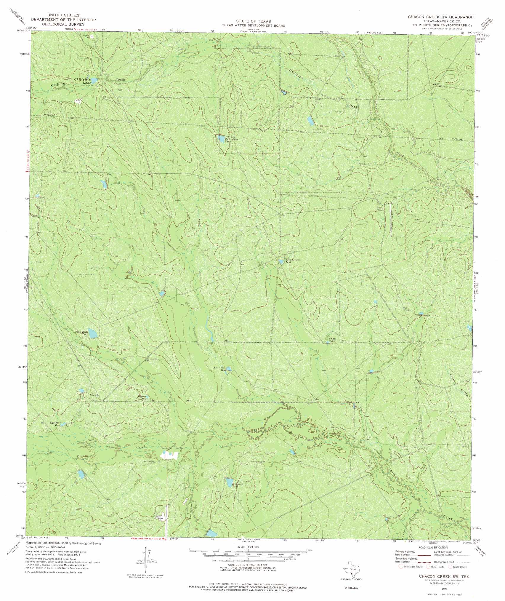
USGS Topo Quad 28100g2 - 1:24,000 scale
| Topo Map Name: | Chacon Creek Sw |
| USGS Topo Quad ID: | 28100g2 |
| Print Size: | ca. 21 1/4" wide x 27" high |
| Southeast Coordinates: | 28.75° N latitude / 100.125° W longitude |
| Map Center Coordinates: | 28.8125° N latitude / 100.1875° W longitude |
| U.S. State: | TX |
| Filename: | o28100g2.jpg |
| Download Map JPG Image: | Chacon Creek Sw topo map 1:24,000 scale |
| Map Type: | Topographic |
| Topo Series: | 7.5´ |
| Map Scale: | 1:24,000 |
| Source of Map Images: | United States Geological Survey (USGS) |
| Alternate Map Versions: |
Chacon Creek SW TX 1974, updated 1977 Download PDF Buy paper map Chacon Creek SW TX 2010 Download PDF Buy paper map Chacon Creek SW TX 2012 Download PDF Buy paper map Chacon Creek SW TX 2016 Download PDF Buy paper map |
1:24,000 Topo Quads surrounding Chacon Creek Sw
Imperialist Tank |
Peloncillo Peak |
Goofy Lake |
Olmos Creek |
Sand Mountain |
Paloma |
Trosado Tank |
Chacon Creek Nw |
Chacon Creek Ne |
La Pryor Nw |
Deadmans Hill |
Indian Tank |
Chacon Creek Sw |
Chacon Creek Se |
Beef Hollow Creek |
Eagle Pass East |
Eagle Pass Ne |
Sacatosa Tank |
Cometa |
Carrizo Springs Nw |
Eagle Pass Sw |
El Indio |
Farias Ranch |
Cayetano Creek |
Carrizo Springs West |
> Back to 28100e1 at 1:100,000 scale
> Back to 28100a1 at 1:250,000 scale
> Back to U.S. Topo Maps home
Chacon Creek Sw topo map: Gazetteer
Chacon Creek Sw: Reservoirs
Americanos Tank elevation 204m 669′Bean Salinas Tank elevation 219m 718′
Chilipitin Lake elevation 225m 738′
Equirada Tank elevation 211m 692′
Pinto Ballo Tank elevation 217m 711′
Rincon Tank elevation 210m 688′
Singleton Tank elevation 210m 688′
Small Tank elevation 207m 679′
Toro Santos Tank elevation 228m 748′
Chacon Creek Sw: Streams
Chilipitin Creek elevation 208m 682′Chimeneas Creek elevation 201m 659′
Chueco Creek elevation 192m 629′
Chacon Creek Sw digital topo map on disk
Buy this Chacon Creek Sw topo map showing relief, roads, GPS coordinates and other geographical features, as a high-resolution digital map file on DVD: