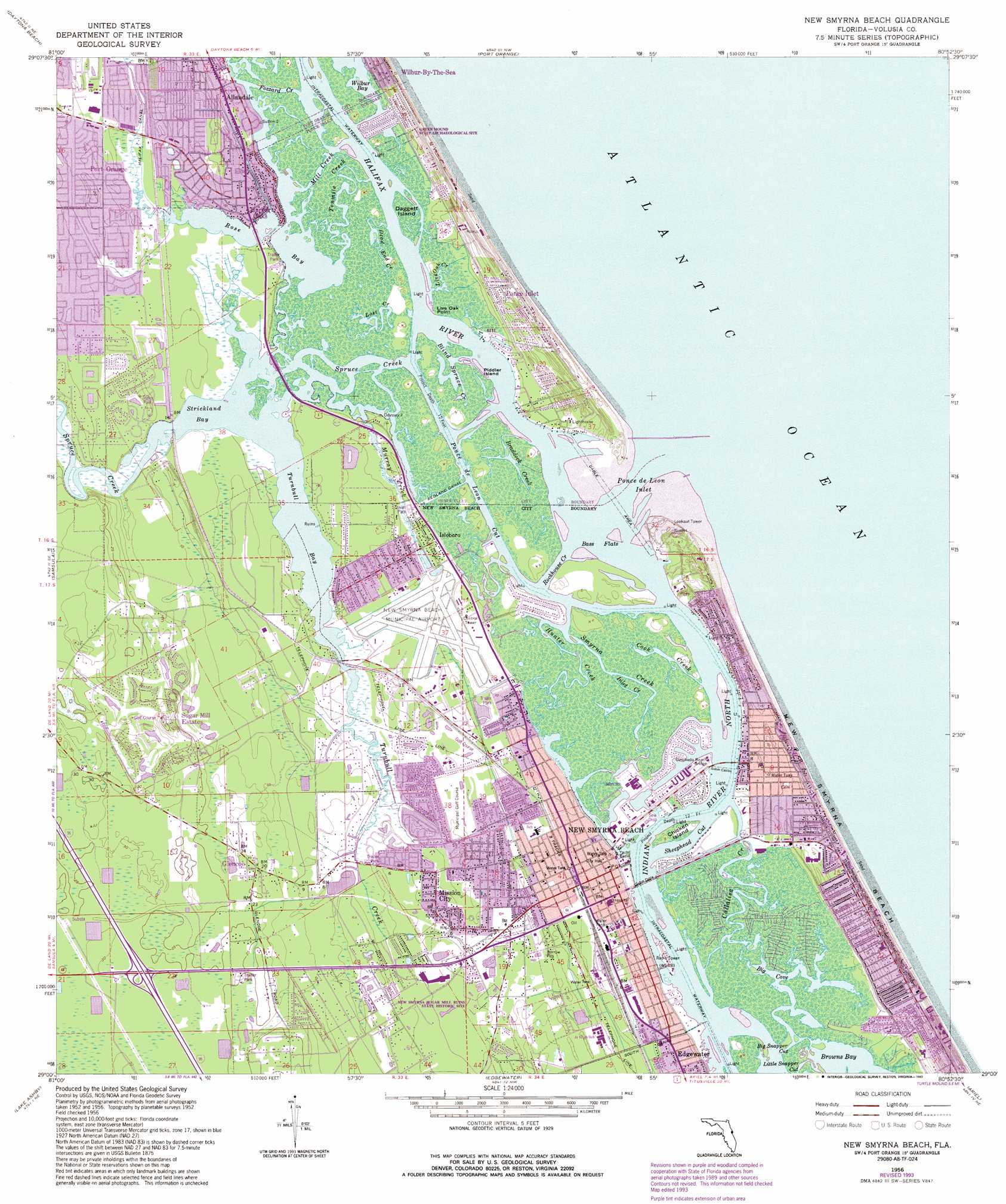
New Smyrna Beach Topo Map Florida
To zoom in, hover over the map of New Smyrna Beach
USGS Topo Quad 29080a8 - 1:24,000 scale
| Topo Map Name: | New Smyrna Beach |
| USGS Topo Quad ID: | 29080a8 |
| Print Size: | ca. 21 1/4" wide x 27" high |
| Southeast Coordinates: | 29° N latitude / 80.875° W longitude |
| Map Center Coordinates: | 29.0625° N latitude / 80.9375° W longitude |
| U.S. State: | FL |
| Filename: | O29080A8.jpg |
| Download Map JPG Image: | New Smyrna Beach topo map 1:24,000 scale |
| Map Type: | Topographic |
| Topo Series: | 7.5´ |
| Map Scale: | 1:24,000 |
| Source of Map Images: | United States Geological Survey (USGS) |
| Alternate Map Versions: |
New Smyrna Beach FL 1956, updated 1960 Download PDF Buy paper map New Smyrna Beach FL 1956, updated 1981 Download PDF Buy paper map New Smyrna Beach FL 1956, updated 1986 Download PDF Buy paper map New Smyrna Beach FL 1956, updated 1988 Download PDF Buy paper map New Smyrna Beach FL 1956, updated 1993 Download PDF Buy paper map New Smyrna Beach FL 2012 Download PDF Buy paper map New Smyrna Beach FL 2015 Download PDF Buy paper map |
1:24,000 Topo Quads surrounding New Smyrna Beach
Favoretta |
Ormond Beach |
|||
Daytona Beach Nw |
Daytona Beach |
Port Orange |
||
Daytona Beach Sw |
Samsula |
New Smyrna Beach |
||
Lake Helen |
Lake Ashby |
Edgewater |
Ariel |
|
Osteen |
Osceola |
Maytown |
Oak Hill |
Pardon Island |
> Back to 29080a1 at 1:100,000 scale
> Back to 29080a1 at 1:250,000 scale
> Back to U.S. Topo Maps home
New Smyrna Beach topo map: Gazetteer
New Smyrna Beach: Airports
New Smyrna Beach Municipal Airport elevation 2m 6′New Smyrna Beach: Bays
Big Cove elevation 0m 0′Blind Spruce Creek elevation 0m 0′
Browns Bay elevation 0m 0′
Inlet Harbor elevation 0m 0′
Rose Bay elevation 0m 0′
Strickland Bay elevation 0m 0′
Turnbull Bay elevation 0m 0′
Wilbur Bay elevation 0m 0′
New Smyrna Beach: Beaches
New Smyrna Beach elevation 0m 0′New Smyrna Beach: Bridges
Coronado Beach Bridge elevation 0m 0′Harris Saxon Bridge elevation 0m 0′
New Smyrna Beach: Canals
Redland Canal elevation 0m 0′New Smyrna Beach: Capes
Live Oak Point elevation 0m 0′New Smyrna Beach: Channels
Big Snapper Cut elevation 0m 0′Little Snapper Cut elevation 0m 0′
Ponce de Leon Cut elevation 0m 0′
Ponce de León Inlet elevation 0m 0′
Sheephead Cut elevation 0m 0′
New Smyrna Beach: Flats
Bass Flats elevation 0m 0′New Smyrna Beach: Guts
Fozzard Creek elevation 0m 0′Lost Creek elevation 0m 0′
Mill Creek elevation 0m 0′
Tenmile Creek elevation 0m 0′
New Smyrna Beach: Islands
Chicken Island elevation 1m 3′Daggett Island elevation 0m 0′
Piddler Island elevation 0m 0′
New Smyrna Beach: Parks
New Smyrna Sugar Mill Ruins State Historic Site elevation 1m 3′New Smyrna Beach: Populated Places
Allandale elevation 1m 3′Allandale Mobile Home Park elevation 1m 3′
Bayview Trailer Park elevation 1m 3′
Briarwood Mobile Estates elevation 3m 9′
Cozy Trailer Park elevation 1m 3′
Glencoe elevation 6m 19′
Gold Rock Park Mobile Home Park elevation 1m 3′
Harbor Oaks elevation 1m 3′
Harbor Oaks Trailer Park elevation 1m 3′
Isleboro elevation 3m 9′
Live Oak Mobile Village elevation 3m 9′
Lutz Mobile Home Park elevation 1m 3′
Maplewood Mobile Estates elevation 1m 3′
Mission City elevation 1m 3′
New Smyrna (historical) elevation 1m 3′
New Smyrna Beach elevation 2m 6′
Ocean Aire Estates Mobile Home Park elevation 3m 9′
Palm Shores Mobile Home Park elevation 1m 3′
Parkwood Manufactured Home Community elevation 3m 9′
Ponce Inlet elevation 4m 13′
Ponce Park elevation 2m 6′
Quail Hollow Mobile Home Park elevation 1m 3′
Redland Estates Mobile Home Community elevation 2m 6′
Riverside Mobile Home Park elevation 1m 3′
Rose Bay Trailer Park elevation 1m 3′
Seahorse Mobile Home Park elevation 2m 6′
Shrocks Trailer Park elevation 2m 6′
Sugar Mill Estates elevation 5m 16′
Sugar Mill Mobile Home Park elevation 7m 22′
Sugar Mill Ruins Travel Park elevation 1m 3′
Treasure Isle Estates Mobile Home Park elevation 1m 3′
White Bird Mobile Home Park elevation 3m 9′
New Smyrna Beach: Post Offices
Allandale Post Office (historical) elevation 1m 3′Smyrna Beach Post Office elevation 2m 6′
New Smyrna Beach: Streams
Braddock Creek elevation 0m 0′Callalisa Creek elevation 0m 0′
Cook Creek elevation 0m 0′
Dead End Creek elevation 0m 0′
Halifax River elevation 0m 0′
Hunter Creek elevation 0m 0′
Inlet Creek elevation 1m 3′
Live Oak Creek elevation 0m 0′
Murray Creek elevation 0m 0′
Rockhouse Creek elevation 0m 0′
Smyrna Creek elevation 0m 0′
Spruce Creek elevation 0m 0′
Spruce Creek elevation 0m 0′
Turnbull Creek elevation 0m 0′
New Smyrna Beach digital topo map on disk
Buy this New Smyrna Beach topo map showing relief, roads, GPS coordinates and other geographical features, as a high-resolution digital map file on DVD: