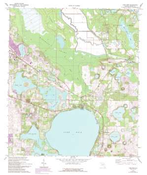
Lake Weir Topo Map Florida
To zoom in, hover over the map of Lake Weir
USGS Topo Quad 29081a8 - 1:24,000 scale
| Topo Map Name: | Lake Weir |
| USGS Topo Quad ID: | 29081a8 |
| Print Size: | ca. 21 1/4" wide x 27" high |
| Southeast Coordinates: | 29° N latitude / 81.875° W longitude |
| Map Center Coordinates: | 29.0625° N latitude / 81.9375° W longitude |
| U.S. State: | FL |
| Filename: | O29081A8.jpg |
| Download Map JPG Image: | Lake Weir topo map 1:24,000 scale |
| Map Type: | Topographic |
| Topo Series: | 7.5´ |
| Map Scale: | 1:24,000 |
| Source of Map Images: | United States Geological Survey (USGS) |
| Alternate Map Versions: |
Lake Weir FL 1970, updated 1973 Download PDF Buy paper map Lake Weir FL 1970, updated 1980 Download PDF Buy paper map Lake Weir FL 1970, updated 1980 Download PDF Buy paper map Lake Weir FL 1970, updated 1993 Download PDF Buy paper map Lake Weir FL 2012 Download PDF Buy paper map Lake Weir FL 2015 Download PDF Buy paper map |
| FStopo: | US Forest Service topo Lake Weir is available: Download FStopo PDF Download FStopo TIF |
1:24,000 Topo Quads surrounding Lake Weir
> Back to 29081a1 at 1:100,000 scale
> Back to 29080a1 at 1:250,000 scale
> Back to U.S. Topo Maps home
Lake Weir topo map: Gazetteer
Lake Weir: Airports
Back Achers Airstrip elevation 26m 85′Jordan Airport elevation 21m 68′
Jordan Heliport elevation 17m 55′
Jordan Seaplane Base elevation 19m 62′
Lake Weir Seaplane Base elevation 17m 55′
Lockheed Martin Heliport elevation 21m 68′
Oklawaha Farms Airport (historical) elevation 12m 39′
Woods and Lakes Airpark elevation 32m 104′
Lake Weir: Beaches
Hampton Beach elevation 18m 59′Lake Weir: Capes
Lemon Point elevation 17m 55′Lake Weir: Dams
Moss Bluff Lock and Dam elevation 18m 59′Lake Weir: Lakes
Blue Sink elevation 20m 65′Bowers Lake elevation 17m 55′
Lake Deon elevation 19m 62′
Lake Fay elevation 20m 65′
Lake Pendarvis elevation 20m 65′
Lake Weir elevation 17m 55′
Little Lake Weir elevation 17m 55′
Moss Bluff Pond elevation 19m 62′
Mud Prairie Lake elevation 18m 59′
Pecan Lake elevation 26m 85′
Round Lake elevation 19m 62′
Silver Lake elevation 25m 82′
Smith Lake elevation 17m 55′
Lake Weir: Populated Places
Candler elevation 32m 104′East Lake Weir elevation 34m 111′
East Silver Springs Shore elevation 26m 85′
Lake Weir elevation 25m 82′
Lake Weir (historical) elevation 17m 55′
Lake Weir Pines Mobile Home Park elevation 23m 75′
Moss Bluff elevation 16m 52′
Ocklawaha elevation 19m 62′
On the Lake Park Mobile Home Park elevation 21m 68′
Smith Lake Shores Village Mobile Home Park elevation 19m 62′
Tall Pines Mobile Home Park elevation 21m 68′
Lake Weir: Post Offices
East Lake Weir Post Office elevation 31m 101′Ocklawaha Post Office elevation 20m 65′
Lake Weir: Swamps
Marshall Swamp elevation 13m 42′Tiger Den elevation 14m 45′
Lake Weir digital topo map on disk
Buy this Lake Weir topo map showing relief, roads, GPS coordinates and other geographical features, as a high-resolution digital map file on DVD:


