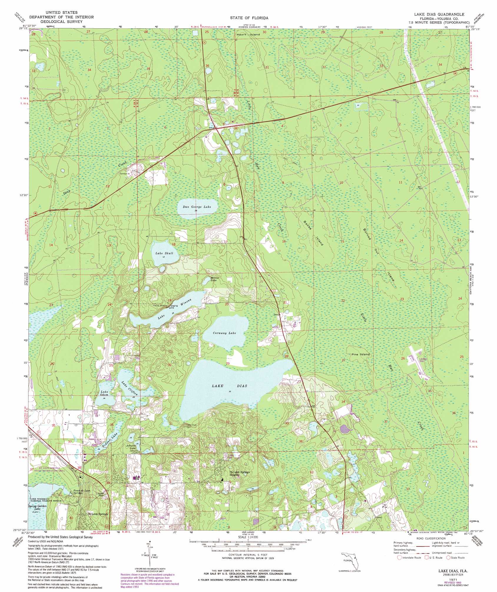
Lake Dias Topo Map Florida
To zoom in, hover over the map of Lake Dias
USGS Topo Quad 29081b3 - 1:24,000 scale
| Topo Map Name: | Lake Dias |
| USGS Topo Quad ID: | 29081b3 |
| Print Size: | ca. 21 1/4" wide x 27" high |
| Southeast Coordinates: | 29.125° N latitude / 81.25° W longitude |
| Map Center Coordinates: | 29.1875° N latitude / 81.3125° W longitude |
| U.S. State: | FL |
| Filename: | O29081B3.jpg |
| Download Map JPG Image: | Lake Dias topo map 1:24,000 scale |
| Map Type: | Topographic |
| Topo Series: | 7.5´ |
| Map Scale: | 1:24,000 |
| Source of Map Images: | United States Geological Survey (USGS) |
| Alternate Map Versions: |
Lake Dias FL 1971, updated 1973 Download PDF Buy paper map Lake Dias FL 1971, updated 1987 Download PDF Buy paper map Lake Dias FL 1971, updated 1993 Download PDF Buy paper map Lake Dias FL 2012 Download PDF Buy paper map Lake Dias FL 2015 Download PDF Buy paper map |
1:24,000 Topo Quads surrounding Lake Dias
Crescent City |
Saint Johns Park |
Bunnell |
Flagler Beach West |
Flagler Beach East |
Welaka Se |
Seville |
Codys Corner |
Favoretta |
Ormond Beach |
Astor |
Pierson |
Lake Dias |
Daytona Beach Nw |
Daytona Beach |
Alexander Springs |
Lake Woodruff |
De Land |
Daytona Beach Sw |
Samsula |
Paisley |
Pine Lakes |
Orange City |
Lake Helen |
Lake Ashby |
> Back to 29081a1 at 1:100,000 scale
> Back to 29080a1 at 1:250,000 scale
> Back to U.S. Topo Maps home
Lake Dias topo map: Gazetteer
Lake Dias: Airports
Lafayette Landings Airport elevation 11m 36′Lake Dias: Islands
Banks Island elevation 11m 36′Burned Out Island elevation 11m 36′
Pine Island elevation 10m 32′
Lake Dias: Lakes
Caraway Lake elevation 11m 36′Dan George Lake elevation 9m 29′
Johnson Lake elevation 8m 26′
Lake Clifton elevation 8m 26′
Lake Dias elevation 10m 32′
Lake Odom elevation 8m 26′
Lake Skull elevation 12m 39′
Lake Winona elevation 11m 36′
Mirror Lake elevation 13m 42′
Tedder Lake elevation 7m 22′
Lake Dias: Parks
De Leon Springs State Park elevation 1m 3′Tomoka Wildlife Management Area Union-Camp Tract elevation 11m 36′
Lake Dias: Populated Places
De Leon Springs Heights elevation 24m 78′Spring Garden Ranch Mobile Home Park elevation 17m 55′
Lake Dias: Springs
Ponce de Leon Springs elevation 1m 3′Lake Dias digital topo map on disk
Buy this Lake Dias topo map showing relief, roads, GPS coordinates and other geographical features, as a high-resolution digital map file on DVD: