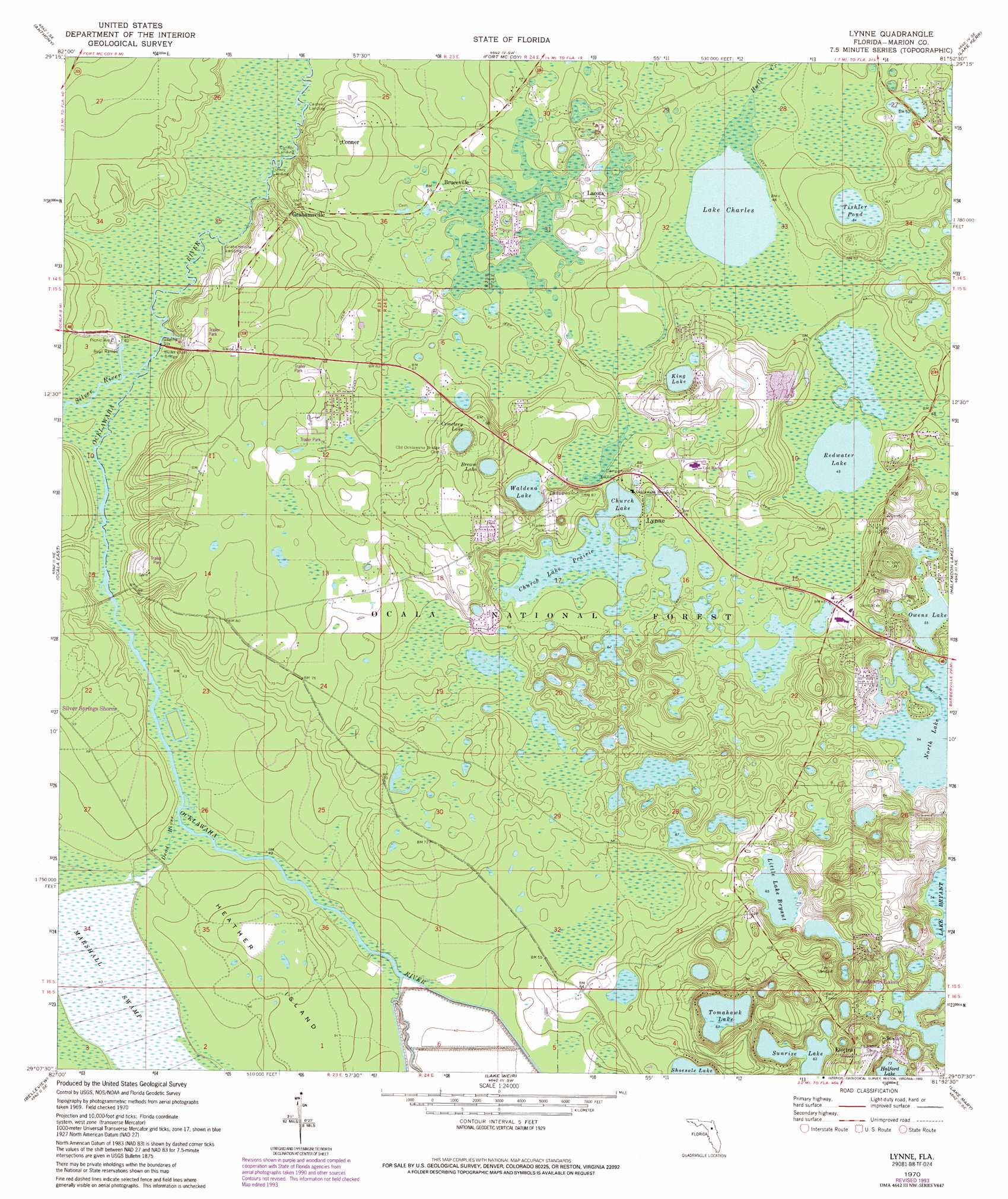
Lynne Topo Map Florida
To zoom in, hover over the map of Lynne
USGS Topo Quad 29081b8 - 1:24,000 scale
| Topo Map Name: | Lynne |
| USGS Topo Quad ID: | 29081b8 |
| Print Size: | ca. 21 1/4" wide x 27" high |
| Southeast Coordinates: | 29.125° N latitude / 81.875° W longitude |
| Map Center Coordinates: | 29.1875° N latitude / 81.9375° W longitude |
| U.S. State: | FL |
| Filename: | O29081B8.jpg |
| Download Map JPG Image: | Lynne topo map 1:24,000 scale |
| Map Type: | Topographic |
| Topo Series: | 7.5´ |
| Map Scale: | 1:24,000 |
| Source of Map Images: | United States Geological Survey (USGS) |
| Alternate Map Versions: |
Lynne FL 1970, updated 1973 Download PDF Buy paper map Lynne FL 1970, updated 1991 Download PDF Buy paper map Lynne FL 1970, updated 1993 Download PDF Buy paper map Lynne FL 2012 Download PDF Buy paper map Lynne FL 2015 Download PDF Buy paper map |
| FStopo: | US Forest Service topo Lynne is available: Download FStopo PDF Download FStopo TIF |
1:24,000 Topo Quads surrounding Lynne
Mcintosh |
Citra |
Eureka Dam |
Lake Delancy |
Welaka |
Reddick |
Anthony |
Fort Mccoy |
Lake Kerr |
Salt Springs |
Ocala West |
Ocala East |
Lynne |
Halfmoon Lake |
Juniper Springs |
Shady |
Belleview |
Lake Weir |
Lake Mary |
Farles Lake |
Lake Panasoffkee Nw |
Oxford |
Lady Lake |
Emeralda Island |
Umatilla |
> Back to 29081a1 at 1:100,000 scale
> Back to 29080a1 at 1:250,000 scale
> Back to U.S. Topo Maps home
Lynne topo map: Gazetteer
Lynne: Airports
Woods and Lakes Airpark elevation 33m 108′Lynne: Bridges
Delks Bluff Bridge elevation 11m 36′Lynne: Islands
Heather Island elevation 16m 52′Lynne: Lakes
Bream Lake elevation 23m 75′Cemetery Lake elevation 23m 75′
Church Lake elevation 19m 62′
King Lake elevation 19m 62′
Lake Charles elevation 13m 42′
Little Lake Bryant elevation 20m 65′
Owens Lake elevation 17m 55′
Redwater Lake elevation 13m 42′
Shoesole Lake elevation 20m 65′
Sunrise Lake elevation 19m 62′
Tishler Pond elevation 16m 52′
Tomahawk Lake elevation 19m 62′
Waldena Lake elevation 20m 65′
Lynne: Parks
Ray Wayside Park elevation 14m 45′Lynne: Populated Places
Bruceville elevation 19m 62′Conner elevation 20m 65′
Deep Woods Mobile Home Park elevation 20m 65′
Electra elevation 33m 108′
Forest Corners elevation 20m 65′
Grahamsville elevation 16m 52′
Lacota elevation 20m 65′
Lake Waldena Resort Mobile Home Park elevation 27m 88′
Lynne elevation 21m 68′
Nubys Corner elevation 20m 65′
Tall Timber Mobile Home Park elevation 25m 82′
Lynne: Streams
Dead River elevation 11m 36′Orange Drain elevation 10m 32′
Silver River elevation 11m 36′
Lynne: Swamps
Church Lake Prairie elevation 19m 62′Lynne digital topo map on disk
Buy this Lynne topo map showing relief, roads, GPS coordinates and other geographical features, as a high-resolution digital map file on DVD: