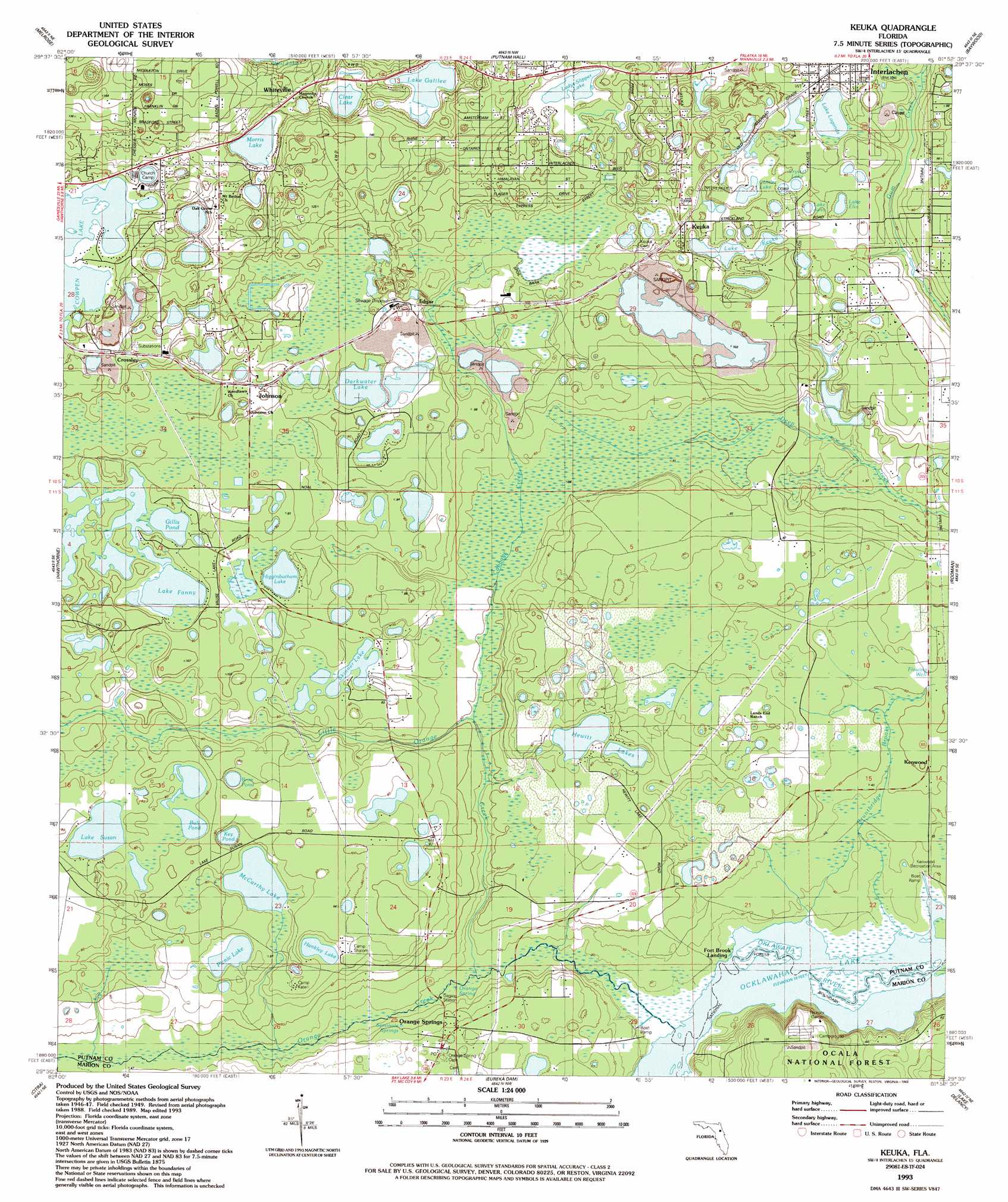
Keuka Topo Map Florida
To zoom in, hover over the map of Keuka
USGS Topo Quad 29081e8 - 1:24,000 scale
| Topo Map Name: | Keuka |
| USGS Topo Quad ID: | 29081e8 |
| Print Size: | ca. 21 1/4" wide x 27" high |
| Southeast Coordinates: | 29.5° N latitude / 81.875° W longitude |
| Map Center Coordinates: | 29.5625° N latitude / 81.9375° W longitude |
| U.S. State: | FL |
| Filename: | O29081E8.jpg |
| Download Map JPG Image: | Keuka topo map 1:24,000 scale |
| Map Type: | Topographic |
| Topo Series: | 7.5´ |
| Map Scale: | 1:24,000 |
| Source of Map Images: | United States Geological Survey (USGS) |
| Alternate Map Versions: |
Keuka FL 1949, updated 1953 Download PDF Buy paper map Keuka FL 1949, updated 1972 Download PDF Buy paper map Keuka FL 1949, updated 1972 Download PDF Buy paper map Keuka FL 1949, updated 1982 Download PDF Buy paper map Keuka FL 1949, updated 1989 Download PDF Buy paper map Keuka FL 1993, updated 1993 Download PDF Buy paper map Keuka FL 2012 Download PDF Buy paper map Keuka FL 2015 Download PDF Buy paper map |
| FStopo: | US Forest Service topo Keuka is available: Download FStopo PDF Download FStopo TIF |
1:24,000 Topo Quads surrounding Keuka
Waldo |
Keystone Heights |
Gold Head Branch |
Rice Creek |
Bostwick |
Orange Heights |
Melrose |
Putnam Hall |
Baywood |
Palatka |
Rochelle |
Hawthorne |
Keuka |
Rodman |
Satsuma |
Mcintosh |
Citra |
Eureka Dam |
Lake Delancy |
Welaka |
Reddick |
Anthony |
Fort Mccoy |
Lake Kerr |
Salt Springs |
> Back to 29081e1 at 1:100,000 scale
> Back to 29080a1 at 1:250,000 scale
> Back to U.S. Topo Maps home
Keuka topo map: Gazetteer
Keuka: Lakes
Brim Pond elevation 22m 72′Bull Pond elevation 25m 82′
Cambo Lake elevation 22m 72′
Clear Lake elevation 25m 82′
Crystal Lake elevation 22m 72′
Darkwater Lake elevation 22m 72′
Gillis Pond elevation 25m 82′
Hankley Lake elevation 22m 72′
Hewitt Lakes elevation 19m 62′
Higginbotham Lake elevation 22m 72′
Key Pond elevation 22m 72′
Ladys-Slipper Lake elevation 25m 82′
Lake Elin elevation 22m 72′
Lake Fanny elevation 25m 82′
Lake Galilee elevation 26m 85′
Lake Keuka elevation 23m 75′
Lake Lagonda elevation 22m 72′
Lake Susan elevation 25m 82′
McCarthy Lake elevation 22m 72′
Morris Lake elevation 28m 91′
Picnic Lake elevation 22m 72′
Skinner Lake elevation 22m 72′
Keuka: Parks
Dowda Park elevation 31m 101′Orange Springs Park elevation 21m 68′
Keuka: Populated Places
Crossley elevation 35m 114′Edgar elevation 25m 82′
Fort Brook Landing elevation 6m 19′
Interlachen elevation 32m 104′
Johnson elevation 31m 101′
Keuka elevation 31m 101′
Lands End Ranch elevation 21m 68′
Orange Springs elevation 18m 59′
Whiteville elevation 48m 157′
Keuka: Post Offices
Edgar Post Office elevation 27m 88′Orange Springs Post Office elevation 20m 65′
Keuka: Reservoirs
Lake Ocklawaha elevation 6m 19′Keuka: Streams
Cabbage Creek elevation 13m 42′Little Orange Creek elevation 8m 26′
Orange Creek elevation 6m 19′
Keuka digital topo map on disk
Buy this Keuka topo map showing relief, roads, GPS coordinates and other geographical features, as a high-resolution digital map file on DVD: