Palatka Topo Map Florida
To zoom in, hover over the map of Palatka
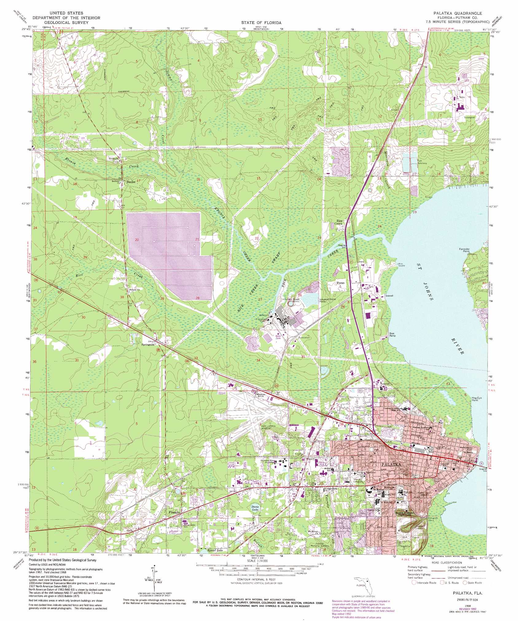
USGS Topo Quad 29081f6 - 1:24,000 scale
| Topo Map Name: | Palatka |
| USGS Topo Quad ID: | 29081f6 |
| Print Size: | ca. 21 1/4" wide x 27" high |
| Southeast Coordinates: | 29.625° N latitude / 81.625° W longitude |
| Map Center Coordinates: | 29.6875° N latitude / 81.6875° W longitude |
| U.S. State: | FL |
| Filename: | O29081F6.jpg |
| Download Map JPG Image: | Palatka topo map 1:24,000 scale |
| Map Type: | Topographic |
| Topo Series: | 7.5´ |
| Map Scale: | 1:24,000 |
| Source of Map Images: | United States Geological Survey (USGS) |
| Alternate Map Versions: |
Palatka FL 1968, updated 1971 Download PDF Buy paper map Palatka FL 1968, updated 1981 Download PDF Buy paper map Palatka FL 1968, updated 1992 Download PDF Buy paper map Palatka FL 1968, updated 1999 Download PDF Buy paper map Palatka FL 2012 Download PDF Buy paper map Palatka FL 2015 Download PDF Buy paper map |
1:24,000 Topo Quads surrounding Palatka
Kingsley |
Penney Farms |
Green Cove Springs |
Picolata |
Bakersville |
Gold Head Branch |
Rice Creek |
Bostwick |
Riverdale |
Elkton |
Putnam Hall |
Baywood |
Palatka |
Hastings |
Spuds |
Keuka |
Rodman |
Satsuma |
San Mateo |
Dinner Island |
Eureka Dam |
Lake Delancy |
Welaka |
Crescent City |
Saint Johns Park |
> Back to 29081e1 at 1:100,000 scale
> Back to 29080a1 at 1:250,000 scale
> Back to U.S. Topo Maps home
Palatka topo map: Gazetteer
Palatka: Airports
Columbia Putnam Community Hospital Heliport elevation 20m 65′Kay Larkin Airport elevation 9m 29′
Putnam Community Hospital Heliport elevation 21m 68′
Palatka: Capes
Forrester Point elevation 2m 6′Hog Eye Point elevation 0m 0′
Palatka: Lakes
Davis Lake elevation 17m 55′Palatka: Parks
Booker Park elevation 4m 13′Bryan Park elevation 8m 26′
Fred Green Park elevation 5m 16′
Mulholland Park elevation 3m 9′
Ravine Gardens State Park elevation 17m 55′
Shaw Buck Park elevation 18m 59′
Palatka: Populated Places
Alhambra Mobile Home Community elevation 20m 65′April Oaks Mobile Home Park elevation 23m 75′
Bardin elevation 7m 22′
Francis elevation 21m 68′
Oaks Landing Mobile Home Park elevation 22m 72′
Palatka elevation 6m 19′
Pecan elevation 5m 16′
Rice Creek elevation 3m 9′
Ryan's Trailer Park elevation 6m 19′
Springside elevation 4m 13′
Springside Park elevation 3m 9′
Teasdale elevation 19m 62′
Villa Farms Mobile Home Park elevation 21m 68′
Watts Trailer Park elevation 20m 65′
Westover Mobile Home Park elevation 23m 75′
Palatka: Post Offices
Palatka Post Office elevation 7m 22′Palatka: Streams
Cow Creek elevation 0m 0′Etonia Creek elevation 1m 3′
Little Rice Creek elevation 1m 3′
Moccasin Creek elevation 1m 3′
Rice Creek elevation 0m 0′
Simms Creek elevation 1m 3′
Palatka: Swamps
Stripper Swamp elevation 7m 22′Palatka digital topo map on disk
Buy this Palatka topo map showing relief, roads, GPS coordinates and other geographical features, as a high-resolution digital map file on DVD: