Putnam Hall Topo Map Florida
To zoom in, hover over the map of Putnam Hall
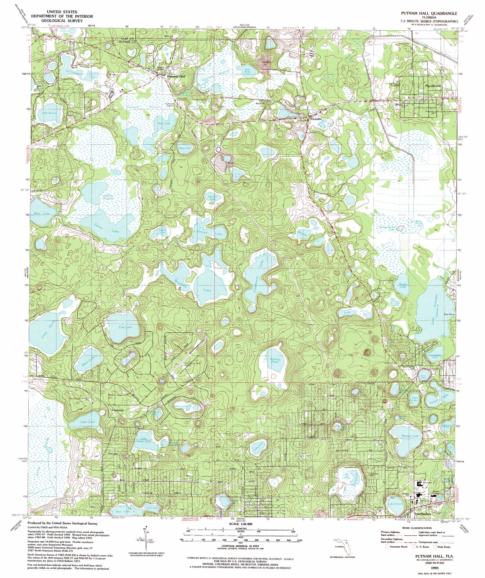
USGS Topo Quad 29081f8 - 1:24,000 scale
| Topo Map Name: | Putnam Hall |
| USGS Topo Quad ID: | 29081f8 |
| Print Size: | ca. 21 1/4" wide x 27" high |
| Southeast Coordinates: | 29.625° N latitude / 81.875° W longitude |
| Map Center Coordinates: | 29.6875° N latitude / 81.9375° W longitude |
| U.S. State: | FL |
| Filename: | O29081F8.jpg |
| Download Map JPG Image: | Putnam Hall topo map 1:24,000 scale |
| Map Type: | Topographic |
| Topo Series: | 7.5´ |
| Map Scale: | 1:24,000 |
| Source of Map Images: | United States Geological Survey (USGS) |
| Alternate Map Versions: |
Putnam Hall FL 1949, updated 1953 Download PDF Buy paper map Putnam Hall FL 1949, updated 1971 Download PDF Buy paper map Putnam Hall FL 1949, updated 1972 Download PDF Buy paper map Putnam Hall FL 1993, updated 1993 Download PDF Buy paper map Putnam Hall FL 2012 Download PDF Buy paper map Putnam Hall FL 2015 Download PDF Buy paper map |
1:24,000 Topo Quads surrounding Putnam Hall
Sampson |
Starke |
Kingsley |
Penney Farms |
Green Cove Springs |
Waldo |
Keystone Heights |
Gold Head Branch |
Rice Creek |
Bostwick |
Orange Heights |
Melrose |
Putnam Hall |
Baywood |
Palatka |
Rochelle |
Hawthorne |
Keuka |
Rodman |
Satsuma |
Mcintosh |
Citra |
Eureka Dam |
Lake Delancy |
Welaka |
> Back to 29081e1 at 1:100,000 scale
> Back to 29080a1 at 1:250,000 scale
> Back to U.S. Topo Maps home
Putnam Hall topo map: Gazetteer
Putnam Hall: Airports
Melrose Landing Airport elevation 46m 150′Putnam Hall: Lakes
Bass Lake elevation 26m 85′Blocker Lake elevation 25m 82′
Boyds Lake elevation 26m 85′
Brantley Lake elevation 26m 85′
Clearwater Lake elevation 26m 85′
Clubhouse Lake elevation 26m 85′
Cooper Lake elevation 26m 85′
Cue Lake elevation 26m 85′
Deep Lake elevation 26m 85′
East Lake elevation 27m 88′
Enslow Lake elevation 26m 85′
Flamingo Lake elevation 25m 82′
Goose Lake elevation 29m 95′
Grassy Lake elevation 23m 75′
Halfmoon Lake elevation 29m 95′
Hart Lake elevation 26m 85′
Hour Glass Lake elevation 29m 95′
Hubbard Pond elevation 26m 85′
Junior Lake elevation 26m 85′
Lake Chipco elevation 26m 85′
Lake Grandin elevation 24m 78′
Lake Green Sills elevation 29m 95′
Lake Loyal elevation 29m 95′
Lake Lucy elevation 26m 85′
Lake Serena elevation 29m 95′
Little Lake Green Sills elevation 29m 95′
Long Lake elevation 27m 88′
Long Pond elevation 25m 82′
Lovers Lake elevation 26m 85′
Mariner Lake elevation 26m 85′
Mason Lake elevation 29m 95′
Newton Lake elevation 26m 85′
Orange Grove Lake elevation 24m 78′
Perch Lake elevation 25m 82′
Ross Lake elevation 29m 95′
Silver Lake elevation 26m 85′
Smith Lake elevation 25m 82′
Trotting Pond elevation 26m 85′
Trout Lake elevation 23m 75′
Wall Lake elevation 29m 95′
West Lake elevation 25m 82′
Whirlwind Lake elevation 25m 82′
Putnam Hall: Parks
Interlachen High School Football Stadium elevation 36m 118′Putnam Hall: Populated Places
Cooper L Hills Estates elevation 60m 196′Florahome elevation 39m 127′
Grandin elevation 32m 104′
Mirror Lake Mobile Home Park elevation 30m 98′
Oak Ridge Park elevation 58m 190′
Putnam Hall elevation 32m 104′
Putnam Hall: Post Offices
Florahome Post Office elevation 39m 127′Grandin Post Office elevation 39m 127′
Interlachen Post Office elevation 23m 75′
Putnam Hall Post Office elevation 30m 98′
Putnam Hall: Swamps
Ashley Prairie elevation 29m 95′Goodson Prairie elevation 25m 82′
Putnam Prairie elevation 29m 95′
Putnam Hall digital topo map on disk
Buy this Putnam Hall topo map showing relief, roads, GPS coordinates and other geographical features, as a high-resolution digital map file on DVD: