Saint Augustine Beach Topo Map Florida
To zoom in, hover over the map of Saint Augustine Beach
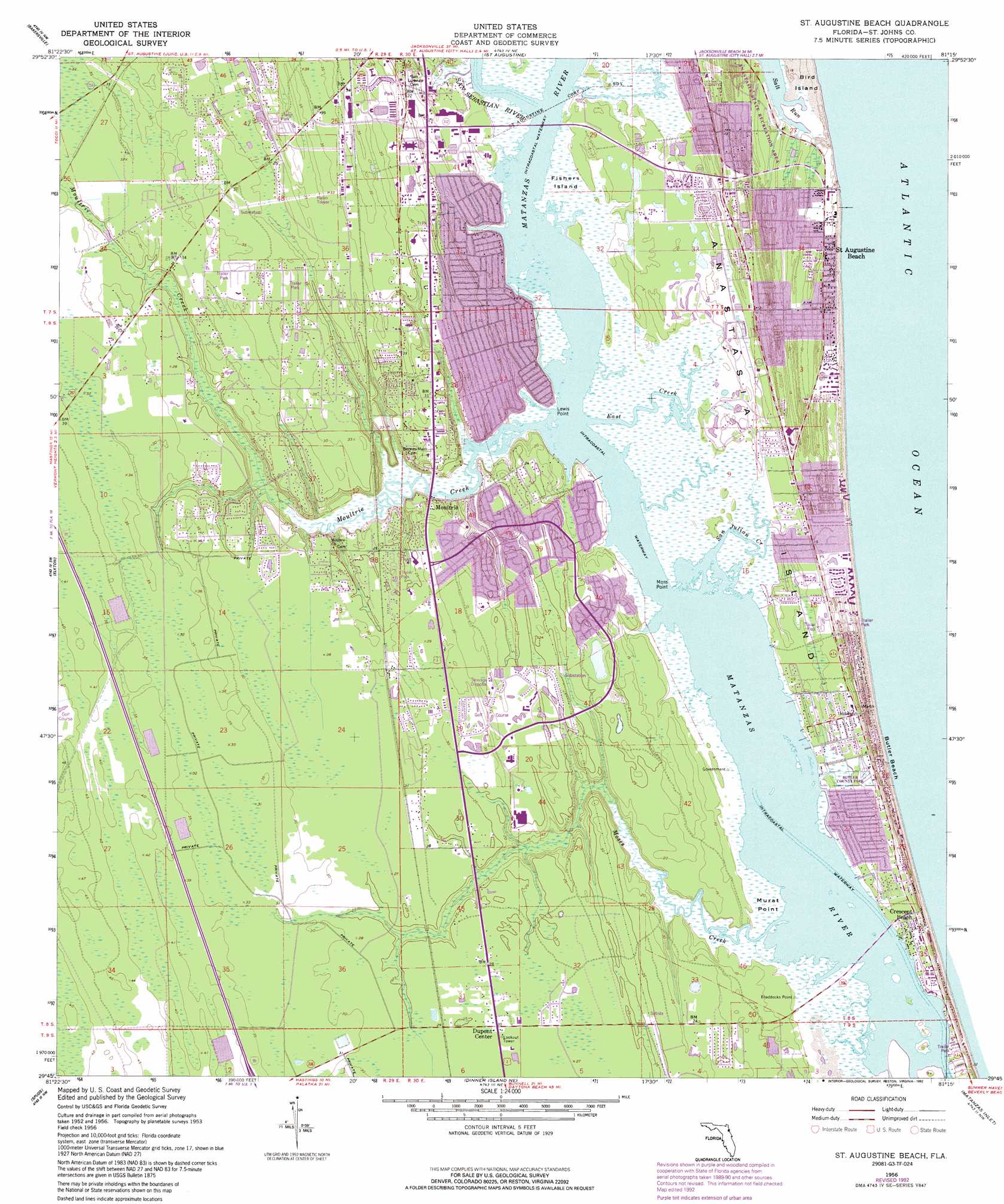
USGS Topo Quad 29081g3 - 1:24,000 scale
| Topo Map Name: | Saint Augustine Beach |
| USGS Topo Quad ID: | 29081g3 |
| Print Size: | ca. 21 1/4" wide x 27" high |
| Southeast Coordinates: | 29.75° N latitude / 81.25° W longitude |
| Map Center Coordinates: | 29.8125° N latitude / 81.3125° W longitude |
| U.S. State: | FL |
| Filename: | O29081G3.jpg |
| Download Map JPG Image: | Saint Augustine Beach topo map 1:24,000 scale |
| Map Type: | Topographic |
| Topo Series: | 7.5´ |
| Map Scale: | 1:24,000 |
| Source of Map Images: | United States Geological Survey (USGS) |
| Alternate Map Versions: |
Crescent Beach FL 1937 Download PDF Buy paper map St. Augustine Beach FL 1956, updated 1961 Download PDF Buy paper map St. Augustine Beach FL 1956, updated 1972 Download PDF Buy paper map St. Augustine Beach FL 1956, updated 1981 Download PDF Buy paper map St. Augustine Beach FL 1956, updated 1988 Download PDF Buy paper map St. Augustine Beach FL 1956, updated 1992 Download PDF Buy paper map Saint Augustine Beach FL 2012 Download PDF Buy paper map Saint Augustine Beach FL 2015 Download PDF Buy paper map |
1:24,000 Topo Quads surrounding Saint Augustine Beach
Orangedale |
Durbin |
South Ponte Vedra Beach |
||
Picolata |
Bakersville |
Saint Augustine |
||
Riverdale |
Elkton |
Saint Augustine Beach |
||
Hastings |
Spuds |
Dinner Island Ne |
Matanzas Inlet |
|
San Mateo |
Dinner Island |
Espanola |
Beverly Beach |
> Back to 29081e1 at 1:100,000 scale
> Back to 29080a1 at 1:250,000 scale
> Back to U.S. Topo Maps home
Saint Augustine Beach topo map: Gazetteer
Saint Augustine Beach: Airports
Flagler Hospital Heliport elevation 3m 9′Saint Augustine Beach: Beaches
Butler Beach elevation 1m 3′Saint Augustine Beach: Bridges
Mickler Oconnel Bridge elevation 0m 0′Saint Augustine Beach: Capes
Braddocks Point elevation 1m 3′Lewis Point elevation 0m 0′
Moss Point elevation 1m 3′
Murat Point elevation 0m 0′
Saint Augustine Beach: Islands
Anastasia Island elevation 1m 3′Bird Island elevation 1m 3′
Fishers Island elevation 1m 3′
Saint Augustine Beach: Parks
Anastasia State Park elevation 1m 3′Butler Beach State Park elevation 1m 3′
Saint Augustine Beach: Populated Places
Beachwood Trailer Park elevation 2m 6′Breezy Brae Mobile Home Park elevation 8m 26′
Butler Beach elevation 1m 3′
Coquina Gables elevation 3m 9′
Crescent Beach elevation 2m 6′
Dimarco Trailer Park elevation 9m 29′
Dupont Center elevation 8m 26′
Easy Street Mobile Home Park elevation 9m 29′
Fort Peyton elevation 8m 26′
Hidden Oaks Mobile Home Park elevation 9m 29′
Hill Creek Mobile Home Park elevation 9m 29′
Hilltop Mobile Home Park elevation 10m 32′
Moultrie elevation 9m 29′
Moultrie Oaks Mobile Home Park elevation 8m 26′
Saint Augustine Beach elevation 2m 6′
Saint Augustine Shores elevation 8m 26′
Saint Augustine South elevation 7m 22′
Saybrook elevation 8m 26′
Sea Horse Retirees Mobile Home Park elevation 9m 29′
Southgate Mobile Home Park elevation 9m 29′
Spanish Trail Mobile Home Park elevation 10m 32′
Taylor Mobile Home Park elevation 10m 32′
Saint Augustine Beach: Streams
East Creek elevation 0m 0′Moses Creek elevation 0m 0′
Moultrie Creek elevation 0m 0′
San Julian Creek elevation 0m 0′
San Sebastian River elevation 0m 0′
Saint Augustine Beach digital topo map on disk
Buy this Saint Augustine Beach topo map showing relief, roads, GPS coordinates and other geographical features, as a high-resolution digital map file on DVD: