Bakersville Topo Map Florida
To zoom in, hover over the map of Bakersville
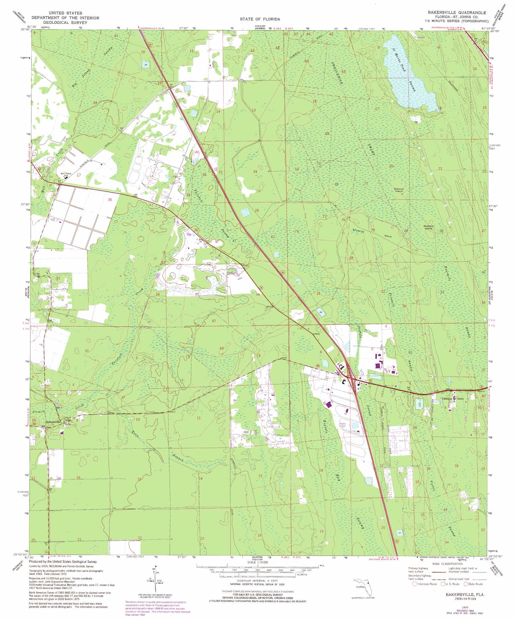
USGS Topo Quad 29081h4 - 1:24,000 scale
| Topo Map Name: | Bakersville |
| USGS Topo Quad ID: | 29081h4 |
| Print Size: | ca. 21 1/4" wide x 27" high |
| Southeast Coordinates: | 29.875° N latitude / 81.375° W longitude |
| Map Center Coordinates: | 29.9375° N latitude / 81.4375° W longitude |
| U.S. State: | FL |
| Filename: | O29081H4.jpg |
| Download Map JPG Image: | Bakersville topo map 1:24,000 scale |
| Map Type: | Topographic |
| Topo Series: | 7.5´ |
| Map Scale: | 1:24,000 |
| Source of Map Images: | United States Geological Survey (USGS) |
| Alternate Map Versions: |
Bakersville FL 1937 Download PDF Buy paper map Bakersville FL 1970, updated 1973 Download PDF Buy paper map Bakersville FL 1970, updated 1992 Download PDF Buy paper map Bakersville FL 2012 Download PDF Buy paper map Bakersville FL 2015 Download PDF Buy paper map |
1:24,000 Topo Quads surrounding Bakersville
Orange Park |
Bayard |
Palm Valley |
Mickler Landing |
|
Fleming Island |
Orangedale |
Durbin |
South Ponte Vedra Beach |
|
Green Cove Springs |
Picolata |
Bakersville |
Saint Augustine |
|
Bostwick |
Riverdale |
Elkton |
Saint Augustine Beach |
|
Palatka |
Hastings |
Spuds |
Dinner Island Ne |
Matanzas Inlet |
> Back to 29081e1 at 1:100,000 scale
> Back to 29080a1 at 1:250,000 scale
> Back to U.S. Topo Maps home
Bakersville topo map: Gazetteer
Bakersville: Airports
Sunshine Farms Airport elevation 7m 22′Bakersville: Islands
Masters Island elevation 10m 32′Simone Island elevation 10m 32′
Sixmile Neck elevation 11m 36′
Bakersville: Populated Places
Bakersville elevation 6m 19′Whispering Oaks Gardens Mobile Home Park elevation 11m 36′
Bakersville: Streams
Town Branch elevation 3m 9′Turnbull Creek elevation 3m 9′
Bakersville: Swamps
Big Island elevation 9m 29′Big Island Swamp elevation 9m 29′
Cowan Swamp elevation 10m 32′
Fivemile Swamp elevation 10m 32′
Fourmile Swamp elevation 10m 32′
Saint Marks Pond Swamp elevation 9m 29′
Sixmile Swamp elevation 12m 39′
Turnbull Swamp elevation 6m 19′
Bakersville digital topo map on disk
Buy this Bakersville topo map showing relief, roads, GPS coordinates and other geographical features, as a high-resolution digital map file on DVD: