Withlacoochee Bay Topo Map Florida
To zoom in, hover over the map of Withlacoochee Bay
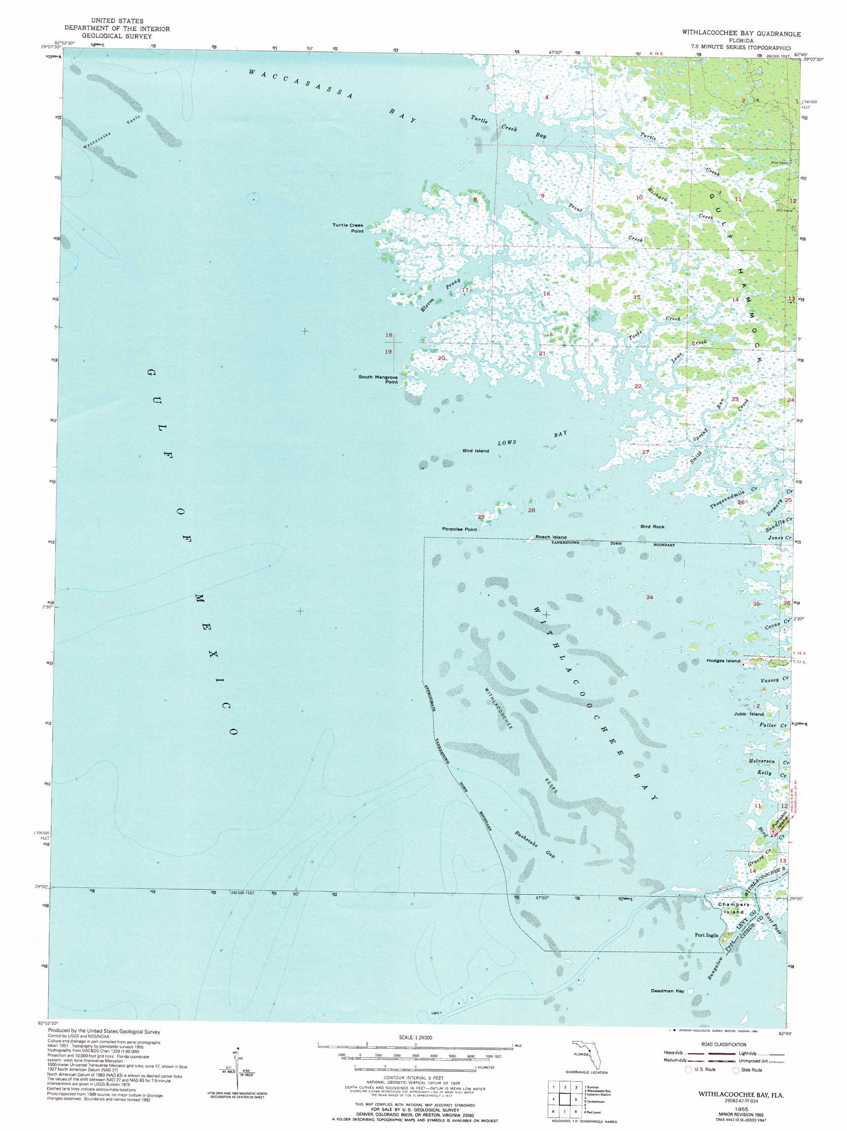
USGS Topo Quad 29082a7 - 1:24,000 scale
| Topo Map Name: | Withlacoochee Bay |
| USGS Topo Quad ID: | 29082a7 |
| Print Size: | ca. 21 1/4" wide x 27" high |
| Southeast Coordinates: | 29° N latitude / 82.75° W longitude |
| Map Center Coordinates: | 29.0625° N latitude / 82.8125° W longitude |
| U.S. State: | FL |
| Filename: | O29082A7.jpg |
| Download Map JPG Image: | Withlacoochee Bay topo map 1:24,000 scale |
| Map Type: | Topographic |
| Topo Series: | 7.5´ |
| Map Scale: | 1:24,000 |
| Source of Map Images: | United States Geological Survey (USGS) |
| Alternate Map Versions: |
Withlacoochee Bay FL 1955, updated 1956 Download PDF Buy paper map Withlacoochee Bay FL 1955, updated 1967 Download PDF Buy paper map Withlacoochee Bay FL 1955, updated 1977 Download PDF Buy paper map Withlacoochee Bay FL 1955, updated 1992 Download PDF Buy paper map Withlacoochee Bay FL 2012 Download PDF Buy paper map Withlacoochee Bay FL 2015 Download PDF Buy paper map |
1:24,000 Topo Quads surrounding Withlacoochee Bay
East Pass |
Chiefland Sw |
Otter Creek |
Bronson Sw |
Bronson Se |
Cedar Key |
Sumner |
Waccasassa Bay |
Lebanon Station |
Tidewater |
Seahorse Key |
Withlacoochee Bay |
Yankeetown |
Yankeetown Se |
|
Red Level |
Crystal River |
|||
Ozello |
Homosassa |
> Back to 29082a1 at 1:100,000 scale
> Back to 29082a1 at 1:250,000 scale
> Back to U.S. Topo Maps home
Withlacoochee Bay topo map: Gazetteer
Withlacoochee Bay: Bars
Waccasassa Reefs elevation 0m 0′Withlacoochee Reefs elevation 0m 0′
Withlacoochee Bay: Bays
Eleven Prong elevation 0m 0′Lows Bay elevation 0m 0′
Turtle Creek Bay elevation 0m 0′
Withlacoochee Bay elevation 0m 0′
Withlacoochee Bay: Capes
Porpoise Point elevation 1m 3′South Mangrove Point elevation 1m 3′
Turtle Creek Point elevation 1m 3′
Withlacoochee Bay: Channels
Bushstake Gap elevation 0m 0′Withlacoochee Bay: Guts
Grassy Creek elevation 0m 0′Withlacoochee Bay: Islands
Bird Island elevation 0m 0′Bird Rock elevation 0m 0′
Hodges Island elevation 0m 0′
Jubb Island elevation 0m 0′
Pumpkin Island elevation 1m 3′
Roach Island elevation 0m 0′
Withlacoochee Bay: Streams
Bird Creek elevation 0m 0′Covas Creek elevation 0m 0′
Demory Creek elevation 0m 0′
Fuller Creek elevation 0m 0′
Helverson Creek elevation 1m 3′
Jones Creek elevation 0m 0′
Kelly Creek elevation 0m 0′
Lows Creek elevation 0m 0′
MacDonald Creek elevation 0m 0′
Richard Creek elevation 0m 0′
Smith Creek elevation 0m 0′
Spring Run elevation 0m 0′
Thousandmile Creek elevation 0m 0′
Tooke Creek elevation 0m 0′
Trout Creek elevation 0m 0′
Turtle Creek elevation 0m 0′
Vassey Creek elevation 0m 0′
Withlacoochee Bay digital topo map on disk
Buy this Withlacoochee Bay topo map showing relief, roads, GPS coordinates and other geographical features, as a high-resolution digital map file on DVD: