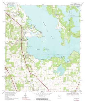
Mcintosh Topo Map Florida
To zoom in, hover over the map of Mcintosh
USGS Topo Quad 29082d2 - 1:24,000 scale
| Topo Map Name: | Mcintosh |
| USGS Topo Quad ID: | 29082d2 |
| Print Size: | ca. 21 1/4" wide x 27" high |
| Southeast Coordinates: | 29.375° N latitude / 82.125° W longitude |
| Map Center Coordinates: | 29.4375° N latitude / 82.1875° W longitude |
| U.S. State: | FL |
| Filename: | O29082D2.jpg |
| Download Map JPG Image: | Mcintosh topo map 1:24,000 scale |
| Map Type: | Topographic |
| Topo Series: | 7.5´ |
| Map Scale: | 1:24,000 |
| Source of Map Images: | United States Geological Survey (USGS) |
| Alternate Map Versions: |
McIntosh FL 1968, updated 1971 Download PDF Buy paper map McIntosh FL 1968, updated 1990 Download PDF Buy paper map McIntosh FL 1968, updated 1990 Download PDF Buy paper map McIntosh FL 2012 Download PDF Buy paper map McIntosh FL 2015 Download PDF Buy paper map |
1:24,000 Topo Quads surrounding Mcintosh
> Back to 29082a1 at 1:100,000 scale
> Back to 29082a1 at 1:250,000 scale
> Back to U.S. Topo Maps home
Mcintosh topo map: Gazetteer
Mcintosh: Airports
Thompson's Goinbroke Aero Ranch elevation 24m 78′Mcintosh: Channels
Cross Creek elevation 17m 55′Mcintosh: Islands
Bird Island elevation 18m 59′Burnt Island elevation 19m 62′
Cane Hammock elevation 20m 65′
Cow Hammock elevation 18m 59′
Hixon Island elevation 17m 55′
McCormick Island elevation 18m 59′
Redbird Island elevation 18m 59′
Mcintosh: Lakes
Orange Lake elevation 17m 55′Right Arm Lochloosa Lake elevation 17m 55′
Mcintosh: Parks
Heagy Burry Park elevation 20m 65′Marjorie Kinnan Rawlings Historic State Park elevation 19m 62′
Marjorie Kinnan Rawlings House and Farm Yard elevation 20m 65′
Mcintosh: Populated Places
Boardman elevation 21m 68′Cross Creek elevation 18m 59′
Evinston elevation 26m 85′
Lakeside Travel Park elevation 18m 59′
McIntosh elevation 33m 108′
Millwood elevation 24m 78′
Orange Lake elevation 33m 108′
Paynes Town (historical) elevation 42m 137′
Mcintosh: Post Offices
Evinston Post Office elevation 22m 72′McIntosh Post Office elevation 23m 75′
Orange Lake Post Office elevation 26m 85′
Mcintosh: Swamps
Hawthorn Prairie elevation 17m 55′Mcintosh digital topo map on disk
Buy this Mcintosh topo map showing relief, roads, GPS coordinates and other geographical features, as a high-resolution digital map file on DVD:


