Fourmile Lake Topo Map Florida
To zoom in, hover over the map of Fourmile Lake
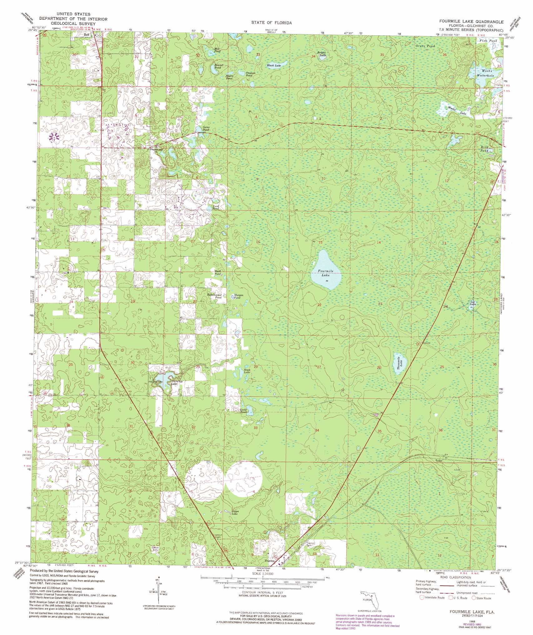
USGS Topo Quad 29082f7 - 1:24,000 scale
| Topo Map Name: | Fourmile Lake |
| USGS Topo Quad ID: | 29082f7 |
| Print Size: | ca. 21 1/4" wide x 27" high |
| Southeast Coordinates: | 29.625° N latitude / 82.75° W longitude |
| Map Center Coordinates: | 29.6875° N latitude / 82.8125° W longitude |
| U.S. State: | FL |
| Filename: | O29082F7.jpg |
| Download Map JPG Image: | Fourmile Lake topo map 1:24,000 scale |
| Map Type: | Topographic |
| Topo Series: | 7.5´ |
| Map Scale: | 1:24,000 |
| Source of Map Images: | United States Geological Survey (USGS) |
| Alternate Map Versions: |
Fourmile Lake FL 1968, updated 1971 Download PDF Buy paper map Fourmile Lake FL 1968, updated 1993 Download PDF Buy paper map Fourmile Lake FL 2012 Download PDF Buy paper map Fourmile Lake FL 2015 Download PDF Buy paper map |
1:24,000 Topo Quads surrounding Fourmile Lake
Mallory Swamp Ne |
Branford |
Hildreth |
Fort White |
Mikesville |
Mallory Swamp Se |
Hatchbend |
Bell |
High Springs Sw |
High Springs |
Cross City East |
Wannee |
Fourmile Lake |
Waters Lake |
Newberry |
Eugene |
Suwannee River |
Trenton |
Newberry Sw |
Archer |
Vista |
Manatee Springs |
Chiefland |
Bronson |
Bronson Ne |
> Back to 29082e1 at 1:100,000 scale
> Back to 29082a1 at 1:250,000 scale
> Back to U.S. Topo Maps home
Fourmile Lake topo map: Gazetteer
Fourmile Lake: Airports
Flying Harness Farms Airport elevation 23m 75′Saw Whet Farms Airport elevation 17m 55′
Watson Flight Strip elevation 17m 55′
Fourmile Lake: Lakes
Bird Pond elevation 18m 59′Black Lake elevation 25m 82′
Black Pond elevation 22m 72′
Bonnet Pond elevation 22m 72′
Bright Lake elevation 26m 85′
Buttonwood Pond elevation 20m 65′
Cannon Pond elevation 24m 78′
Fourmile Lake elevation 26m 85′
Gator Pond elevation 24m 78′
Goose Pond elevation 18m 59′
Grass Pond elevation 23m 75′
Jennings Lake elevation 13m 42′
Joppa Lake elevation 13m 42′
Lee Lake elevation 26m 85′
Mill Pond elevation 22m 72′
Morgan Pond elevation 21m 68′
Negro Pond elevation 24m 78′
Sapp Lake elevation 19m 62′
Threemile Lake elevation 26m 85′
Wash Pond elevation 20m 65′
Weeks Lake elevation 22m 72′
Weeks Waterhole elevation 22m 72′
Yard Pond elevation 22m 72′
Fourmile Lake: Populated Places
Mutual elevation 21m 68′Tyler elevation 26m 85′
Fourmile Lake: Swamps
Waccasassa Flats elevation 23m 75′Fourmile Lake digital topo map on disk
Buy this Fourmile Lake topo map showing relief, roads, GPS coordinates and other geographical features, as a high-resolution digital map file on DVD: