High Springs Topo Map Florida
To zoom in, hover over the map of High Springs
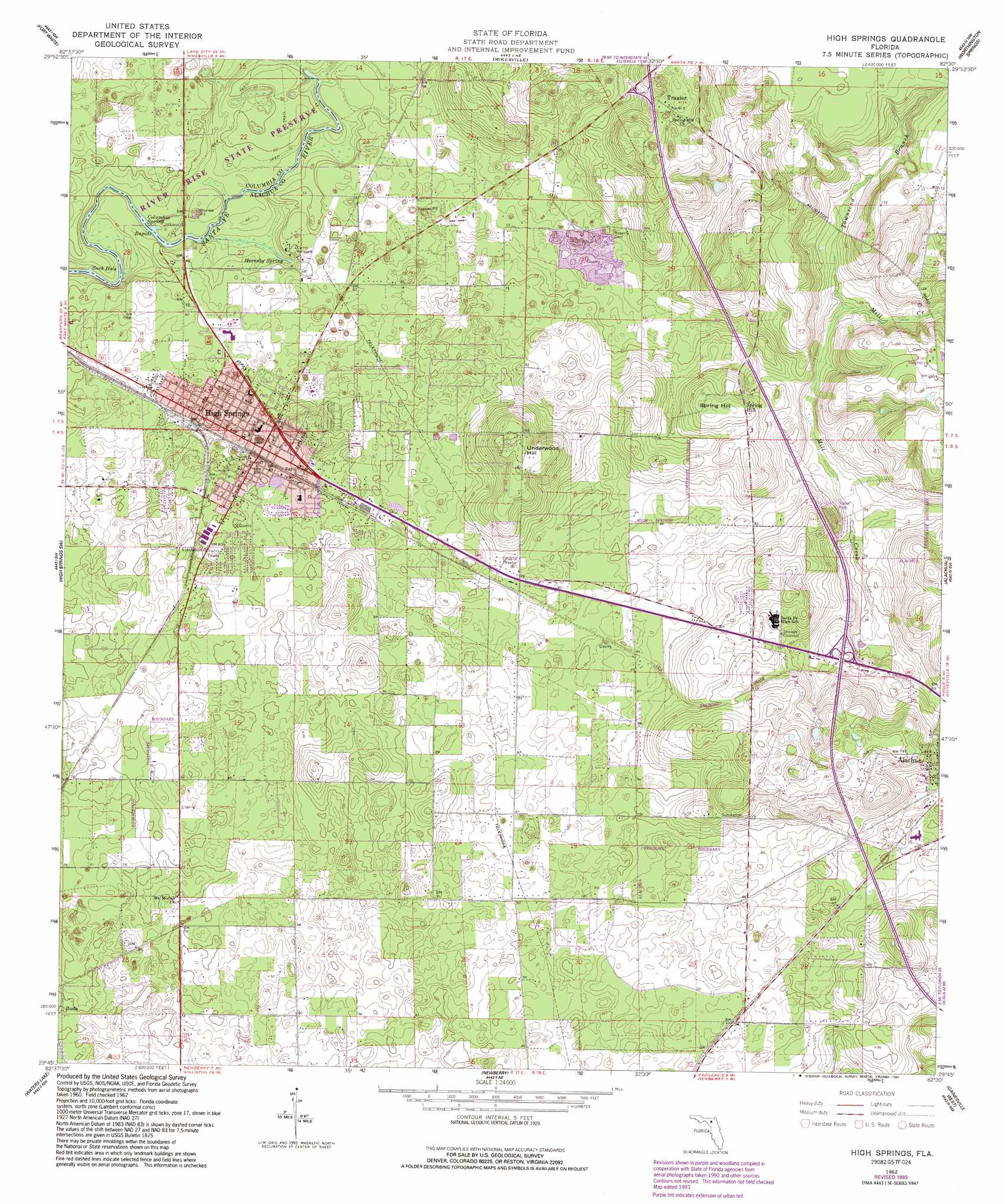
USGS Topo Quad 29082g5 - 1:24,000 scale
| Topo Map Name: | High Springs |
| USGS Topo Quad ID: | 29082g5 |
| Print Size: | ca. 21 1/4" wide x 27" high |
| Southeast Coordinates: | 29.75° N latitude / 82.5° W longitude |
| Map Center Coordinates: | 29.8125° N latitude / 82.5625° W longitude |
| U.S. State: | FL |
| Filename: | O29082G5.jpg |
| Download Map JPG Image: | High Springs topo map 1:24,000 scale |
| Map Type: | Topographic |
| Topo Series: | 7.5´ |
| Map Scale: | 1:24,000 |
| Source of Map Images: | United States Geological Survey (USGS) |
| Alternate Map Versions: |
High Springs FL 1962, updated 1963 Download PDF Buy paper map High Springs FL 1962, updated 1976 Download PDF Buy paper map High Springs FL 1962, updated 1991 Download PDF Buy paper map High Springs FL 1962, updated 1993 Download PDF Buy paper map High Springs FL 2012 Download PDF Buy paper map High Springs FL 2015 Download PDF Buy paper map |
1:24,000 Topo Quads surrounding High Springs
O'Brien Se |
Columbia |
Ellisville |
Lulu |
Lake Butler |
Hildreth |
Fort White |
Mikesville |
Worthington Springs |
Brooker |
Bell |
High Springs Sw |
High Springs |
Alachua |
Monteocha |
Fourmile Lake |
Waters Lake |
Newberry |
Gainesville West |
Gainesville East |
Trenton |
Newberry Sw |
Archer |
Arredondo |
Micanopy |
> Back to 29082e1 at 1:100,000 scale
> Back to 29082a1 at 1:250,000 scale
> Back to U.S. Topo Maps home
High Springs topo map: Gazetteer
High Springs: Airports
Camp Kulaqua Airport (historical) elevation 16m 52′High Springs: Bays
Suck Hole elevation 8m 26′High Springs: Parks
Catherine Taylor Park elevation 22m 72′City of Alachua Recreation and Community Center elevation 28m 91′
City of High Springs Memorial Park elevation 30m 98′
Old Bellamy Camp Park elevation 29m 95′
River Rise Preserve State Park elevation 10m 32′
High Springs: Populated Places
Arno elevation 27m 88′High Springs elevation 20m 65′
Johnnys Mobile Home Park elevation 21m 68′
Spring Hill elevation 40m 131′
Traxler elevation 50m 164′
High Springs: Post Offices
High Springs Post Office elevation 19m 62′High Springs: Springs
Columbia Spring elevation 10m 32′Hornsby Spring elevation 10m 32′
High Springs: Streams
Townsend Branch elevation 19m 62′High Springs: Summits
Spring Hill elevation 43m 141′Underwood Hill elevation 55m 180′
High Springs digital topo map on disk
Buy this High Springs topo map showing relief, roads, GPS coordinates and other geographical features, as a high-resolution digital map file on DVD: