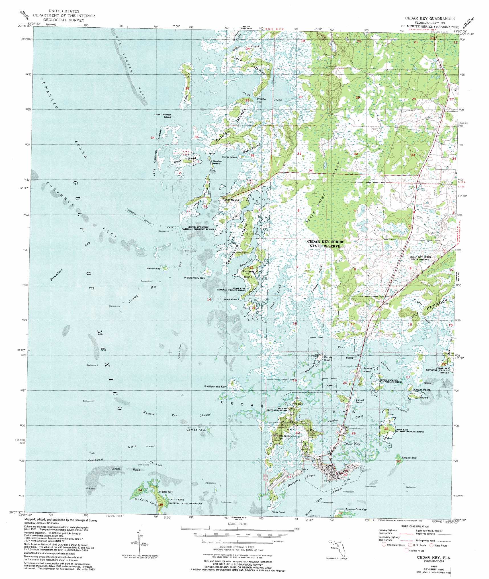
Cedar Key Topo Map Florida
To zoom in, hover over the map of Cedar Key
USGS Topo Quad 29083b1 - 1:24,000 scale
| Topo Map Name: | Cedar Key |
| USGS Topo Quad ID: | 29083b1 |
| Print Size: | ca. 21 1/4" wide x 27" high |
| Southeast Coordinates: | 29.125° N latitude / 83° W longitude |
| Map Center Coordinates: | 29.1875° N latitude / 83.0625° W longitude |
| U.S. State: | FL |
| Filename: | O29083B1.jpg |
| Download Map JPG Image: | Cedar Key topo map 1:24,000 scale |
| Map Type: | Topographic |
| Topo Series: | 7.5´ |
| Map Scale: | 1:24,000 |
| Source of Map Images: | United States Geological Survey (USGS) |
| Alternate Map Versions: |
Cedar Key FL 1955, updated 1956 Download PDF Buy paper map Cedar Key FL 1955, updated 1963 Download PDF Buy paper map Cedar Key FL 1955, updated 1969 Download PDF Buy paper map Cedar Key FL 1955, updated 1993 Download PDF Buy paper map Cedar Key FL 2012 Download PDF Buy paper map Cedar Key FL 2015 Download PDF Buy paper map |
1:24,000 Topo Quads surrounding Cedar Key
Horseshoe Beach |
Shired Island |
Vista |
Manatee Springs |
Chiefland |
Suwannee |
East Pass |
Chiefland Sw |
Otter Creek |
|
Cedar Key |
Sumner |
Waccasassa Bay |
||
Seahorse Key |
Withlacoochee Bay |
|||
> Back to 29083a1 at 1:100,000 scale
> Back to 29082a1 at 1:250,000 scale
> Back to U.S. Topo Maps home
Cedar Key topo map: Gazetteer
Cedar Key: Airports
George T Lewis Airport elevation 1m 3′Lewis Landing Field elevation 2m 6′
Cedar Key: Bars
Lone Cabbage Reef elevation 0m 0′North Bank elevation 0m 0′
Pelican Reef elevation 0m 0′
South Bank elevation 0m 0′
Suwannee Reef elevation 0m 0′
White Shell Bar elevation 0m 0′
Cedar Key: Bays
Daughtry Bayou elevation 0m 0′McCrary Cove elevation 0m 0′
Preacher Hole elevation 0m 0′
Cedar Key: Capes
Black Point elevation 0m 0′Cedar Point elevation 0m 0′
Piney Point elevation 0m 0′
Sunset Point elevation 0m 0′
Cedar Key: Channels
Derrick Key Gap elevation 0m 0′Northwest Channel elevation 0m 0′
Number Four Channel elevation 0m 0′
Number Three Channel elevation 0m 0′
Steamboat Gap elevation 0m 0′
Cedar Key: Islands
Buck Island elevation 2m 6′Candy Island elevation 2m 6′
Cedar Keys elevation 0m 0′
Clark Island elevation 1m 3′
Deer Island elevation 1m 3′
Derrick Key elevation 1m 3′
Dog Island elevation 1m 3′
Garden Island elevation 0m 0′
Gomez Keys elevation 1m 3′
Gulf Hammock elevation 4m 13′
Havens Island elevation 3m 9′
Hog Island elevation 1m 3′
Horse Island elevation 0m 0′
Live Oak Key elevation 1m 3′
Lone Cabbage Island elevation 0m 0′
Long Cabbage Island elevation 0m 0′
McClamory Key elevation 1m 3′
North Key elevation 1m 3′
Raleigh Islands elevation 1m 3′
Rattlesnake Key elevation 1m 3′
Richards Island elevation 3m 9′
Rye Key elevation 1m 3′
Scale Key elevation 1m 3′
Seabreeze Island elevation 3m 9′
Spanish Bayonet Island elevation 1m 3′
Way Key elevation 1m 3′
Cedar Key: Parks
Cedar Key elevation 1m 3′Cedar Key Museum State Park elevation 2m 6′
Cedar Key Scrub State Reserve elevation 1m 3′
Cedar Key State Memorial elevation 2m 6′
Cedar Key: Populated Places
Cedar Key elevation 3m 9′Wakasassa (historical) elevation 1m 3′
Cedar Key: Streams
Clark Creek elevation 0m 0′Dennis Creek elevation 0m 0′
Ericson Creek elevation 0m 0′
Giger Creek elevation 0m 0′
Goose Creek elevation 0m 0′
Horse Island Creek elevation 1m 3′
Lukens Creek elevation 0m 0′
Prodie Creek elevation 0m 0′
Sand Creek elevation 0m 0′
Seabreeze Creek elevation 0m 0′
Cedar Key: Summits
Hodgson Hill elevation 11m 36′Shell Mound elevation 6m 19′
Cedar Key: Swamps
Black Point Swamp elevation 1m 3′Cedar Key digital topo map on disk
Buy this Cedar Key topo map showing relief, roads, GPS coordinates and other geographical features, as a high-resolution digital map file on DVD: