East Pass Topo Map Florida
To zoom in, hover over the map of East Pass
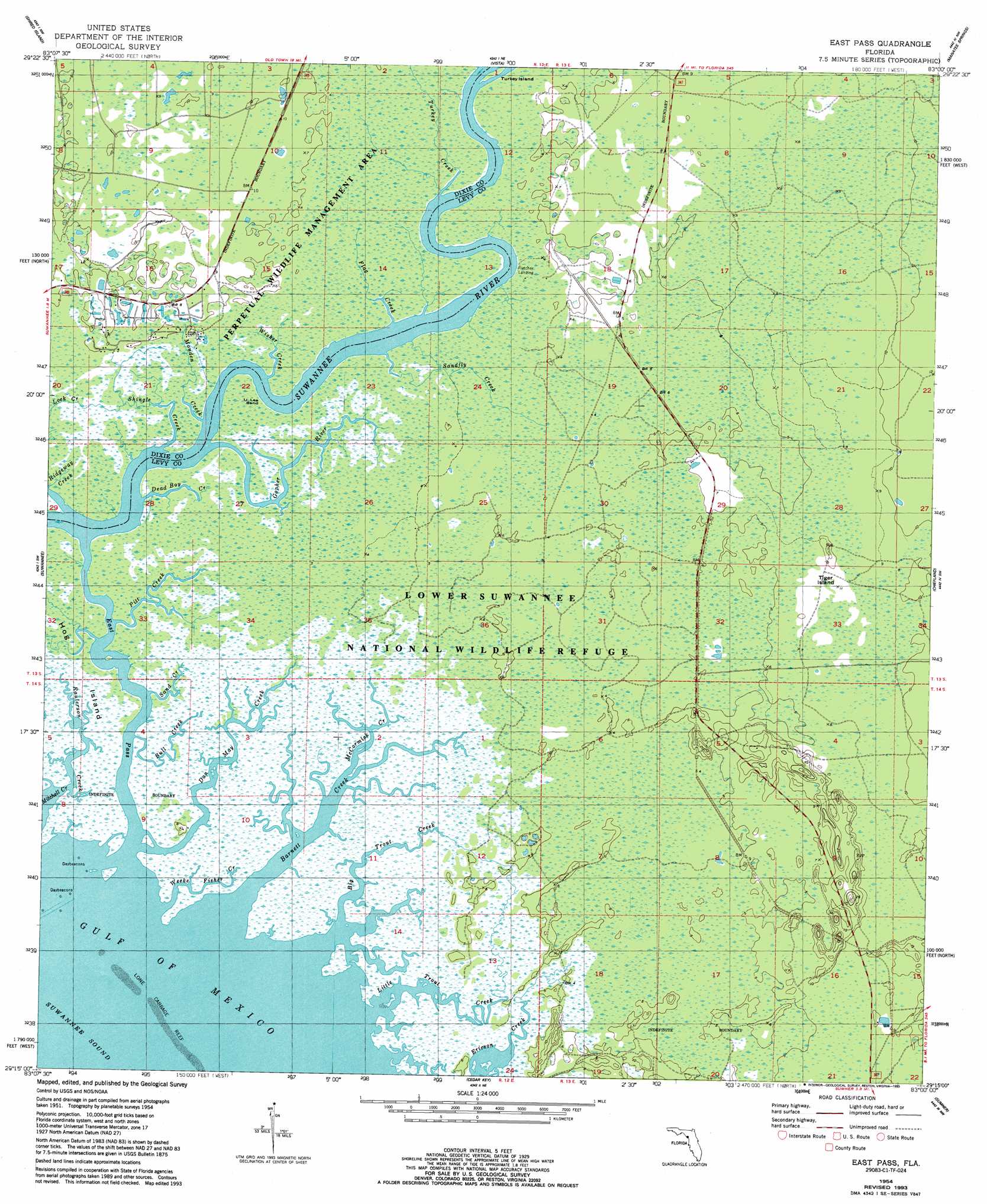
USGS Topo Quad 29083c1 - 1:24,000 scale
| Topo Map Name: | East Pass |
| USGS Topo Quad ID: | 29083c1 |
| Print Size: | ca. 21 1/4" wide x 27" high |
| Southeast Coordinates: | 29.25° N latitude / 83° W longitude |
| Map Center Coordinates: | 29.3125° N latitude / 83.0625° W longitude |
| U.S. State: | FL |
| Filename: | O29083C1.jpg |
| Download Map JPG Image: | East Pass topo map 1:24,000 scale |
| Map Type: | Topographic |
| Topo Series: | 7.5´ |
| Map Scale: | 1:24,000 |
| Source of Map Images: | United States Geological Survey (USGS) |
| Alternate Map Versions: |
East Pass FL 1954, updated 1956 Download PDF Buy paper map East Pass FL 1954, updated 1959 Download PDF Buy paper map East Pass FL 1954, updated 1990 Download PDF Buy paper map East Pass FL 1954, updated 1993 Download PDF Buy paper map East Pass FL 2012 Download PDF Buy paper map East Pass FL 2015 Download PDF Buy paper map |
1:24,000 Topo Quads surrounding East Pass
Steinhatchee Se |
Cross City Sw |
Eugene |
Suwannee River |
Trenton |
Horseshoe Beach |
Shired Island |
Vista |
Manatee Springs |
Chiefland |
Suwannee |
East Pass |
Chiefland Sw |
Otter Creek |
|
Cedar Key |
Sumner |
Waccasassa Bay |
||
Seahorse Key |
Withlacoochee Bay |
> Back to 29083a1 at 1:100,000 scale
> Back to 29082a1 at 1:250,000 scale
> Back to U.S. Topo Maps home
East Pass topo map: Gazetteer
East Pass: Bends
U-Lee Bend elevation 0m 0′East Pass: Channels
East Pass elevation 0m 0′East Pass: Islands
Tiger Island elevation 2m 6′Turkey Island elevation 0m 0′
East Pass: Populated Places
Beech Creek (historical) elevation 1m 3′East Pass: Streams
Barnett Creek elevation 0m 0′Big Trout Creek elevation 0m 0′
Bull Creek elevation 0m 0′
Dan May Creek elevation 0m 0′
Dead Boy Creek elevation 0m 0′
Flag Creek elevation 0m 0′
Gopher River elevation 0m 0′
Little Trout Creek elevation 0m 0′
McCormick Creek elevation 1m 3′
Monden Creek elevation 0m 0′
Pitt Creek elevation 0m 0′
Ridgeway Creek elevation 0m 0′
Sand Creek elevation 0m 0′
Sandfly Creek elevation 0m 0′
Shingle Creek elevation 0m 0′
Turkey Creek elevation 0m 0′
Weeks Fisher Creek elevation 0m 0′
Wisher Creek elevation 0m 0′
East Pass digital topo map on disk
Buy this East Pass topo map showing relief, roads, GPS coordinates and other geographical features, as a high-resolution digital map file on DVD: