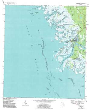
Suwannee Topo Map Florida
To zoom in, hover over the map of Suwannee
USGS Topo Quad 29083c2 - 1:24,000 scale
| Topo Map Name: | Suwannee |
| USGS Topo Quad ID: | 29083c2 |
| Print Size: | ca. 21 1/4" wide x 27" high |
| Southeast Coordinates: | 29.25° N latitude / 83.125° W longitude |
| Map Center Coordinates: | 29.3125° N latitude / 83.1875° W longitude |
| U.S. State: | FL |
| Filename: | O29083C2.jpg |
| Download Map JPG Image: | Suwannee topo map 1:24,000 scale |
| Map Type: | Topographic |
| Topo Series: | 7.5´ |
| Map Scale: | 1:24,000 |
| Source of Map Images: | United States Geological Survey (USGS) |
| Alternate Map Versions: |
Suwannee FL 1954, updated 1956 Download PDF Buy paper map Suwannee FL 1954, updated 1967 Download PDF Buy paper map Suwannee FL 1954, updated 1987 Download PDF Buy paper map Suwannee FL 1954, updated 1993 Download PDF Buy paper map Suwannee FL 2012 Download PDF Buy paper map Suwannee FL 2015 Download PDF Buy paper map |
1:24,000 Topo Quads surrounding Suwannee
Steinhatchee Sw |
Steinhatchee Se |
Cross City Sw |
Eugene |
Suwannee River |
Horseshoe Beach |
Shired Island |
Vista |
Manatee Springs |
|
Suwannee |
East Pass |
Chiefland Sw |
||
Cedar Key |
Sumner |
|||
Seahorse Key |
> Back to 29083a1 at 1:100,000 scale
> Back to 29082a1 at 1:250,000 scale
> Back to U.S. Topo Maps home
Suwannee topo map: Gazetteer
Suwannee: Bars
Halfmoon Reef elevation 0m 0′Suwannee Reef elevation 0m 0′
Suwannee: Channels
Alligator Pass elevation 0m 0′Boiler Gap elevation 0m 0′
Magnesia Pass elevation 0m 0′
Northern Pass elevation 0m 0′
Ranch Bar Gap elevation 0m 0′
Wadley Pass elevation 0m 0′
West Pass elevation 0m 0′
Suwannee: Islands
Axe Island elevation 0m 0′Barbree Island elevation 1m 3′
Bradford Island elevation 0m 0′
Bumblebee Island elevation 0m 0′
Cat Island elevation 0m 0′
Coon Island elevation 1m 3′
Crutchman Island elevation 0m 0′
Goodson Island elevation 0m 0′
Harris Island elevation 0m 0′
Hog Island elevation 0m 0′
Little Bird Island elevation 0m 0′
Little Bradford Island elevation 0m 0′
Little Bumblebee Island elevation 0m 0′
Little Pine Island elevation 0m 0′
Odulund Island elevation 0m 0′
Palm Island elevation 0m 0′
Suwannee: Parks
Lower Suwannee National Wildlife Refuge elevation 1m 3′Perpetual Wildlife Management Area elevation 0m 0′
Suwannee: Populated Places
Suwannee elevation 3m 9′Suwannee: Streams
Big Magnesia Creek elevation 0m 0′Bird Island Creek elevation 0m 0′
Bumblebee Creek elevation 0m 0′
Demory Creek elevation 0m 0′
Harden Creek elevation 0m 0′
Harris Creek elevation 0m 0′
Hog Island Creek elevation 0m 0′
Little Harden Creek elevation 0m 0′
Little Magnesia Creek elevation 0m 0′
Lock Creek elevation 0m 0′
Mitchell Creek elevation 0m 0′
Moccasin Creek elevation 0m 0′
North Double Barrel Creek elevation 0m 0′
Raulerson Creek elevation 0m 0′
Salt Creek elevation 0m 0′
Sanders Creek elevation 0m 0′
South Double Barrel Creek elevation 0m 0′
Suwannee River elevation 0m 0′
Suwannee digital topo map on disk
Buy this Suwannee topo map showing relief, roads, GPS coordinates and other geographical features, as a high-resolution digital map file on DVD:


