Apalachicola Topo Map Florida
To zoom in, hover over the map of Apalachicola
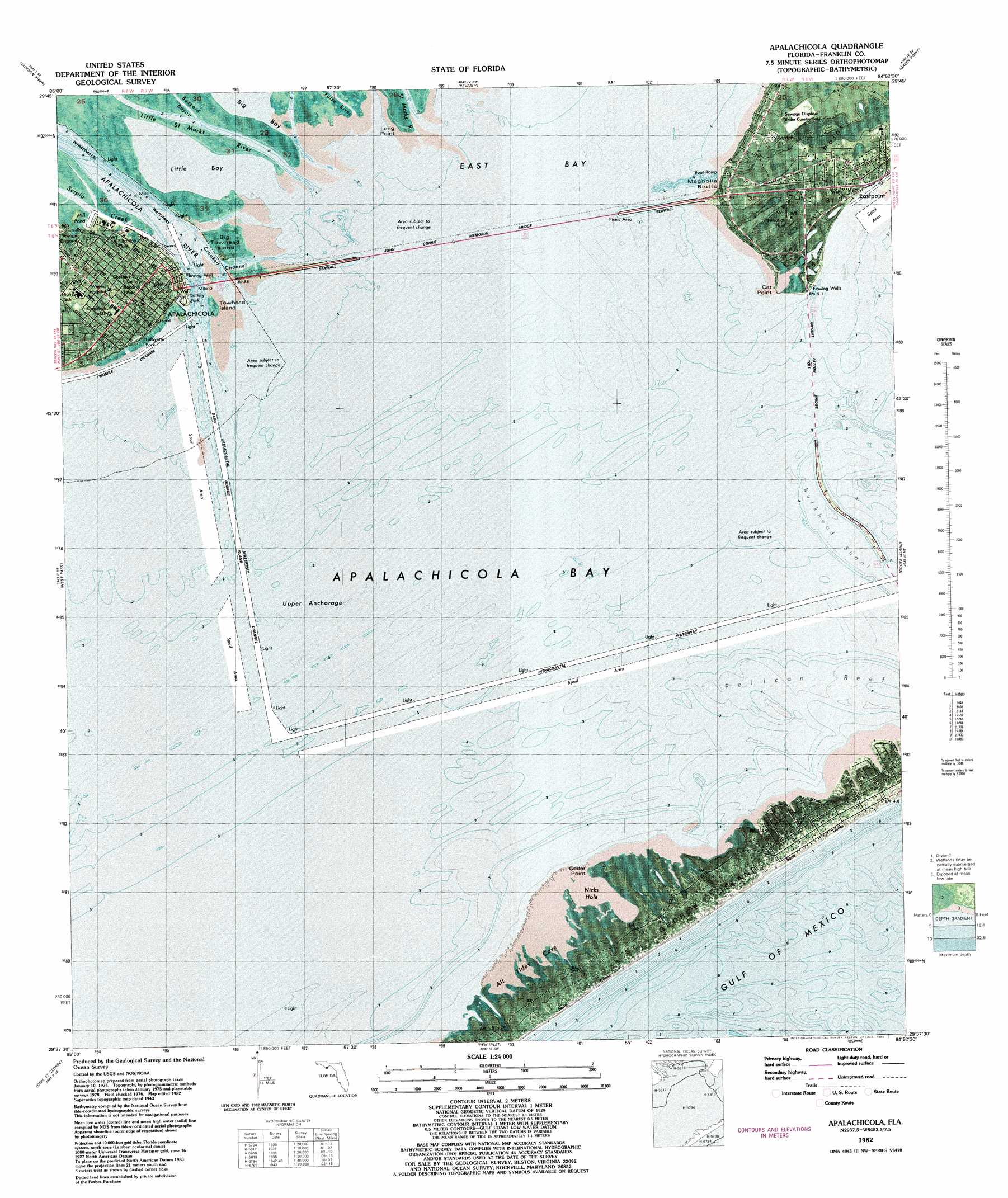
USGS Topo Quad 29084f8 - 1:24,000 scale
| Topo Map Name: | Apalachicola |
| USGS Topo Quad ID: | 29084f8 |
| Print Size: | ca. 21 1/4" wide x 27" high |
| Southeast Coordinates: | 29.625° N latitude / 84.875° W longitude |
| Map Center Coordinates: | 29.6875° N latitude / 84.9375° W longitude |
| U.S. State: | FL |
| Filename: | P29084f8.jpg |
| Download Map JPG Image: | Apalachicola topo map 1:24,000 scale |
| Map Type: | Orthophoto |
| Topo Series: | 7.5´ |
| Map Scale: | 1:24,000 |
| Source of Map Images: | United States Geological Survey (USGS) |
| Alternate Map Versions: |
Apalachicola FL 1943, updated 1960 Download PDF Buy paper map Apalachicola FL 1944, updated 1960 Download PDF Buy paper map Apalachicola FL 1982, updated 1983 Download PDF Buy paper map Apalachicola FL 2012 Download PDF Buy paper map Apalachicola FL 2015 Download PDF Buy paper map |
1:24,000 Topo Quads surrounding Apalachicola
White City |
Forbes Island |
Fort Gadsden |
Tates Hell Swamp |
Pickett Bay |
Lake Wimico |
Jackson River |
Beverly |
Green Point |
Carrabelle |
Indian Pass |
West Pass |
Apalachicola |
Goose Island |
Sugar Hill |
Cape Saint George |
New Inlet |
|||
> Back to 29084e1 at 1:100,000 scale
> Back to 29084a1 at 1:250,000 scale
> Back to U.S. Topo Maps home
Apalachicola topo map: Gazetteer
Apalachicola: Airports
Saint George Island Airport elevation 1m 3′Apalachicola: Bars
Bulkhead Shoal elevation 0m 0′Apalachicola: Bays
All Tides Cove elevation 0m 0′Apalachicola Bay elevation 0m 0′
Little Bay elevation 0m 0′
Apalachicola: Bridges
Apalachicola Bay Bridge elevation 0m 0′John Gorrie Memorial Bridge elevation 0m 0′
Apalachicola: Capes
Cat Point elevation 0m 0′Cedar Point elevation 0m 0′
East Point elevation 4m 13′
Long Point elevation 1m 3′
Apalachicola: Channels
Scipio Creek Channel elevation 0m 0′Apalachicola: Islands
Big Towhead Island elevation 1m 3′Saint George Island elevation 3m 9′
Towhead Island elevation 1m 3′
Apalachicola: Parks
Apalachicola Bay Aquatic Preserve elevation 0m 0′John Gorrie Museum State Park elevation 4m 13′
Apalachicola: Populated Places
Apalachicola elevation 4m 13′Eastpoint elevation 2m 6′
Magnolia Bluffs elevation 6m 19′
Saint George Island elevation 1m 3′
Apalachicola: Streams
Apalachicola River elevation 0m 0′Little Saint Marks River elevation 0m 0′
Saint Marks River elevation 0m 0′
Scipio Creek elevation 1m 3′
Apalachicola digital topo map on disk
Buy this Apalachicola topo map showing relief, roads, GPS coordinates and other geographical features, as a high-resolution digital map file on DVD:
Gulf Coast (LA, MS, AL, FL) & Southwestern Georgia
Buy digital topo maps: Gulf Coast (LA, MS, AL, FL) & Southwestern Georgia
 & Southwestern Georgia map DVD")