Saint Teresa Beach Topo Map Florida
To zoom in, hover over the map of Saint Teresa Beach
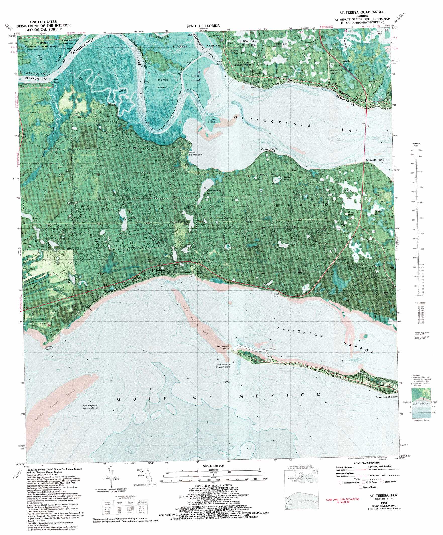
USGS Topo Quad 29084h4 - 1:24,000 scale
| Topo Map Name: | Saint Teresa Beach |
| USGS Topo Quad ID: | 29084h4 |
| Print Size: | ca. 21 1/4" wide x 27" high |
| Southeast Coordinates: | 29.875° N latitude / 84.375° W longitude |
| Map Center Coordinates: | 29.9375° N latitude / 84.4375° W longitude |
| U.S. State: | FL |
| Filename: | P29084h4.jpg |
| Download Map JPG Image: | Saint Teresa Beach topo map 1:24,000 scale |
| Map Type: | Orthophoto |
| Topo Series: | 7.5´ |
| Map Scale: | 1:24,000 |
| Source of Map Images: | United States Geological Survey (USGS) |
| Alternate Map Versions: |
St. Teresa Beach FL 1943, updated 1969 Download PDF Buy paper map St. Teresa FL 1945, updated 1960 Download PDF Buy paper map St. Teresa FL 1981, updated 1982 Download PDF Buy paper map St. Teresa FL 1981, updated 1992 Download PDF Buy paper map Saint Teresa FL 2012 Download PDF Buy paper map Saint Teresa FL 2015 Download PDF Buy paper map |
1:24,000 Topo Quads surrounding Saint Teresa Beach
Smith Creek |
Bradwell Bay |
Crawfordville West |
Crawfordville East |
Saint Marks |
Thousand Yard Bay |
Sanborn |
Sopchoppy |
Spring Creek |
Sprague Island |
Pickett Bay |
Mcintyre |
Saint Teresa Beach |
Lighthouse Point |
|
Carrabelle |
Dog Island |
|||
Sugar Hill |
> Back to 29084e1 at 1:100,000 scale
> Back to 29084a1 at 1:250,000 scale
> Back to U.S. Topo Maps home
Saint Teresa Beach topo map: Gazetteer
Saint Teresa Beach: Airports
Wakulla County Airport elevation 2m 6′Saint Teresa Beach: Bars
Bay Mouth Bar elevation 0m 0′Saint Teresa Beach: Bays
Ochlockonee Bay elevation 0m 0′Saint Teresa Beach: Beaches
Wilson Beach elevation 6m 19′Saint Teresa Beach: Bridges
Walker Bridge elevation 0m 0′Saint Teresa Beach: Capes
Granit Point elevation 0m 0′Metcalf Point elevation 0m 0′
Peninsula Point elevation 1m 3′
Southwest Cape elevation 1m 3′
Turkey Point elevation 1m 3′
Saint Teresa Beach: Channels
Shell Island elevation 2m 6′Saint Teresa Beach: Harbors
Alligator Harbor elevation 0m 0′Saint Teresa Beach: Islands
Grass Island elevation 0m 0′Shell Hammock elevation 0m 0′
Saint Teresa Beach: Lakes
Buddy Pond elevation 1m 3′Corn Landing Lake elevation 1m 3′
Halfway Lake elevation 5m 16′
Metcalf Lake elevation 1m 3′
Silver Lake elevation 3m 9′
Silver Lake elevation 3m 9′
Saint Teresa Beach: Parks
Alligator Harbor Aquatic Preserve elevation 0m 0′Saint Teresa Beach: Populated Places
Saint Teresa elevation 6m 19′Surf elevation 2m 6′
Saint Teresa Beach: Post Offices
Saint Teresa Post Office (historical) elevation 6m 19′Saint Teresa Beach: Streams
Little Tide Creek elevation 0m 0′Ochlockonee River elevation 0m 0′
Sopchoppy River elevation 0m 0′
Tide Creek elevation 0m 0′
Saint Teresa Beach digital topo map on disk
Buy this Saint Teresa Beach topo map showing relief, roads, GPS coordinates and other geographical features, as a high-resolution digital map file on DVD:
Gulf Coast (LA, MS, AL, FL) & Southwestern Georgia
Buy digital topo maps: Gulf Coast (LA, MS, AL, FL) & Southwestern Georgia
 & Southwestern Georgia map DVD")