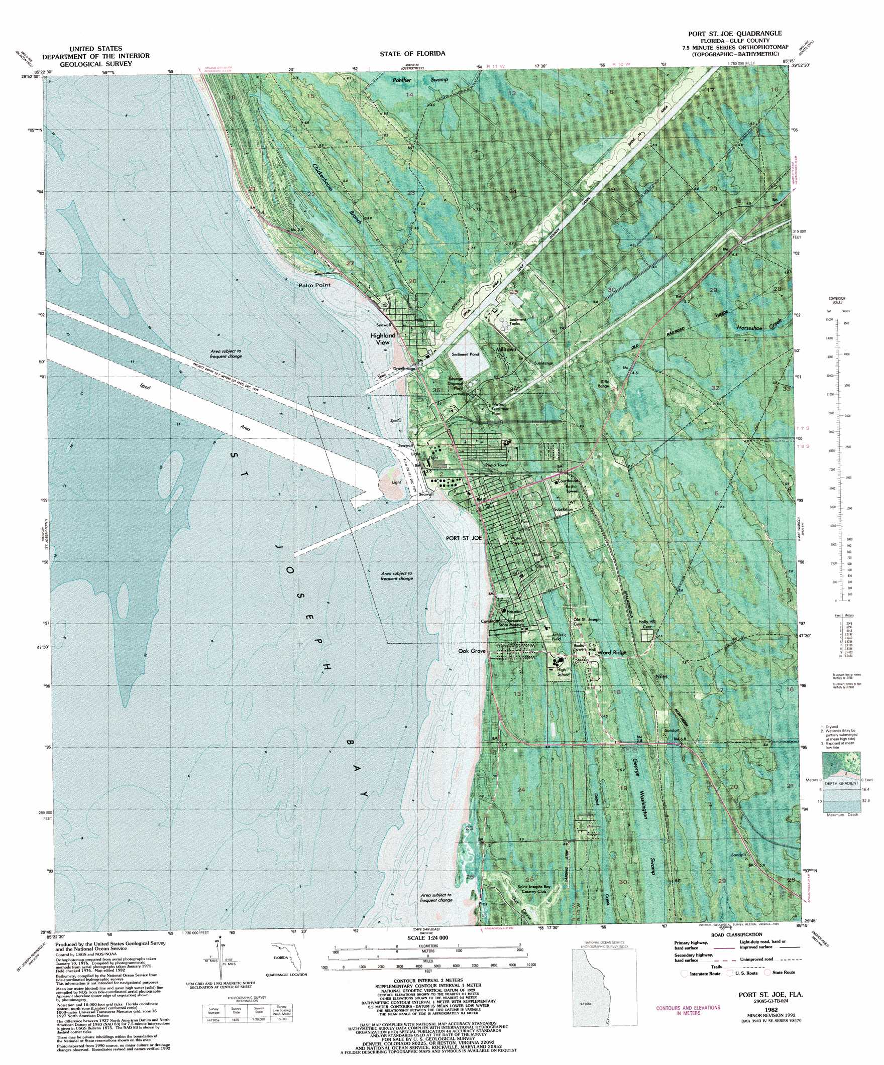
Port Saint Joe Topo Map Florida
To zoom in, hover over the map of Port Saint Joe
USGS Topo Quad 29085g3 - 1:24,000 scale
| Topo Map Name: | Port Saint Joe |
| USGS Topo Quad ID: | 29085g3 |
| Print Size: | ca. 21 1/4" wide x 27" high |
| Southeast Coordinates: | 29.75° N latitude / 85.25° W longitude |
| Map Center Coordinates: | 29.8125° N latitude / 85.3125° W longitude |
| U.S. State: | FL |
| Filename: | P29085G3.jpg |
| Download Map JPG Image: | Port Saint Joe topo map 1:24,000 scale |
| Map Type: | Orthophoto |
| Topo Series: | 7.5´ |
| Map Scale: | 1:24,000 |
| Source of Map Images: | United States Geological Survey (USGS) |
| Alternate Map Versions: |
Port St. Joe FL 1943, updated 1960 Download PDF Buy paper map Port St. Joe FL 1943, updated 1960 Download PDF Buy paper map Port St. Joe FL 1982, updated 1983 Download PDF Buy paper map Port St. Joe FL 1982, updated 1993 Download PDF Buy paper map Port Saint Joe FL 2012 Download PDF Buy paper map Port Saint Joe FL 2015 Download PDF Buy paper map |
1:24,000 Topo Quads surrounding Port Saint Joe
Long Point |
Allanton |
Wetappo Creek |
Wewahitchka |
Kennedy Creek |
Crooked Island |
Beacon Hill |
Overstreet |
White City |
Forbes Island |
Saint Joseph Point |
Port Saint Joe |
Lake Wimico |
Jackson River |
|
Saint Joseph Spit |
Cape San Blas |
Indian Pass |
West Pass |
|
Cape Saint George |
> Back to 29085e1 at 1:100,000 scale
> Back to 29084a1 at 1:250,000 scale
> Back to U.S. Topo Maps home
Port Saint Joe topo map: Gazetteer
Port Saint Joe: Airports
Costin Airport elevation 4m 13′Port Saint Joe: Bays
Saint Joseph Bay elevation 0m 0′Port Saint Joe: Bridges
George G Tapper Bridge elevation 0m 0′Oak Grove Bridge elevation 1m 3′
Port Saint Joe: Canals
Gulf County Canal elevation 3m 9′Port Saint Joe: Capes
Palm Point elevation 1m 3′Port Saint Joe: Parks
Constitution Convention Museum State Park elevation 2m 6′Saint Joseph Bay Aquatic Preserve elevation 0m 0′
Port Saint Joe: Populated Places
Highland View elevation 3m 9′Milltown elevation 6m 19′
Niles elevation 7m 22′
Oak Grove elevation 2m 6′
Port Saint Joe elevation 2m 6′
Ward Ridge elevation 4m 13′
Port Saint Joe: Swamps
Chickenhouse Branch elevation 4m 13′George Washington Swamp elevation 4m 13′
Port Saint Joe digital topo map on disk
Buy this Port Saint Joe topo map showing relief, roads, GPS coordinates and other geographical features, as a high-resolution digital map file on DVD:
Gulf Coast (LA, MS, AL, FL) & Southwestern Georgia
Buy digital topo maps: Gulf Coast (LA, MS, AL, FL) & Southwestern Georgia
 & Southwestern Georgia map DVD")