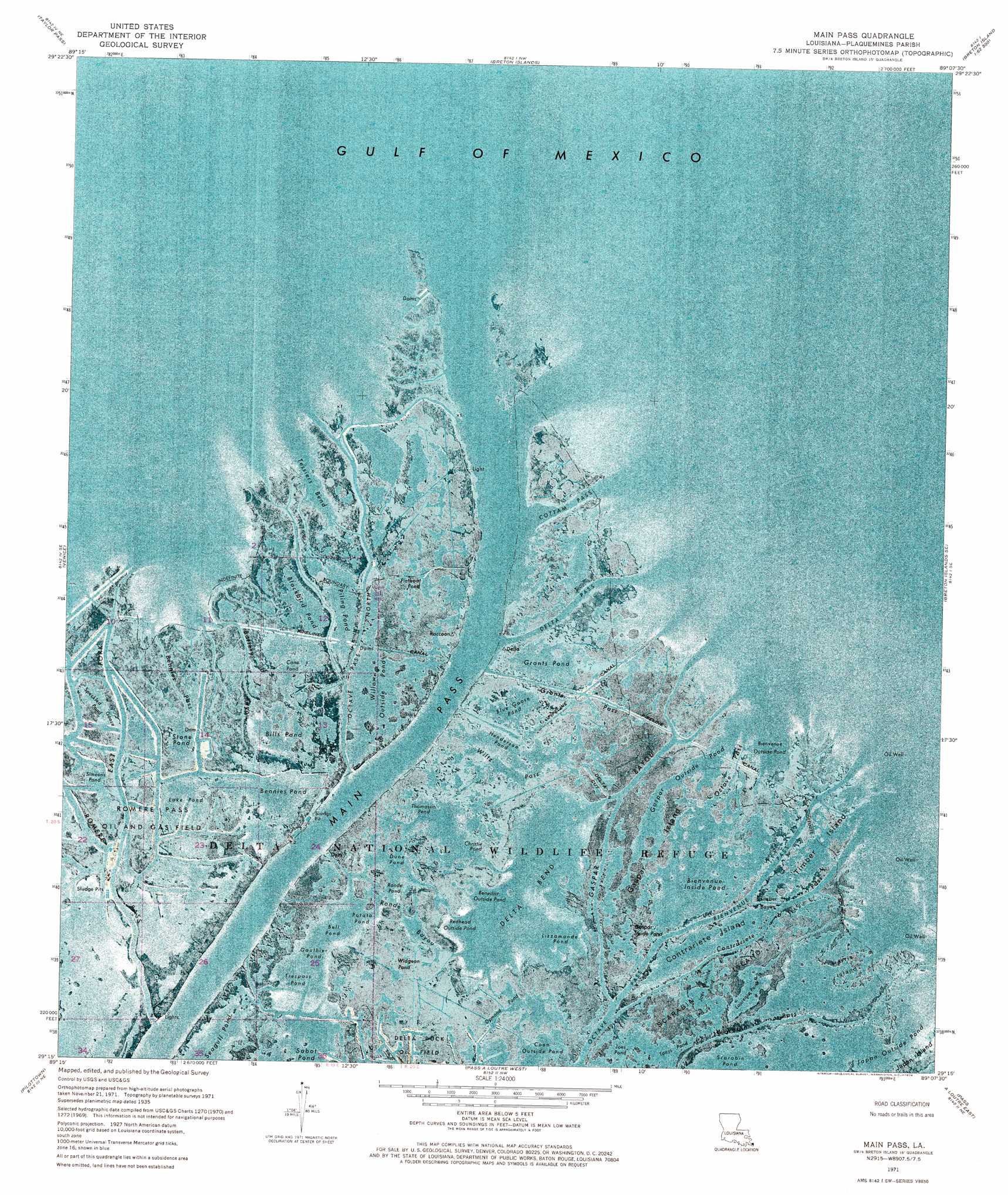
Main Pass Topo Map Louisiana
To zoom in, hover over the map of Main Pass
USGS Topo Quad 29089c2 - 1:24,000 scale
| Topo Map Name: | Main Pass |
| USGS Topo Quad ID: | 29089c2 |
| Print Size: | ca. 21 1/4" wide x 27" high |
| Southeast Coordinates: | 29.25° N latitude / 89.125° W longitude |
| Map Center Coordinates: | 29.3125° N latitude / 89.1875° W longitude |
| U.S. State: | LA |
| Filename: | p29089c2.jpg |
| Download Map JPG Image: | Main Pass topo map 1:24,000 scale |
| Map Type: | Orthophoto |
| Topo Series: | 7.5´ |
| Map Scale: | 1:24,000 |
| Source of Map Images: | United States Geological Survey (USGS) |
| Alternate Map Versions: |
Main Pass LA 1971, updated 1974 Download PDF Buy paper map Main Pass LA 1971, updated 1974 Download PDF Buy paper map Main Pass LA 2012 Download PDF Buy paper map Main Pass LA 2015 Download PDF Buy paper map |
1:24,000 Topo Quads surrounding Main Pass
Coquille Point |
Taylor Pass |
Breton Islands |
||
Triumph |
Venice |
Main Pass |
Breton Islands Se |
|
Pass Tante Phine |
Pilottown |
Pass A Loutre West |
Pass A Loutre East |
|
Pass Du Bois |
Dixon Bay |
South Pass |
Garden Island Pass |
> Back to 29089a1 at 1:100,000 scale
> Back to 29088a1 at 1:250,000 scale
> Back to U.S. Topo Maps home
Main Pass topo map: Gazetteer
Main Pass: Airports
Romere Pass Seaplane Base elevation 0m 0′Main Pass: Bays
Bell Pond elevation 0m 0′Benedict Outside Pond elevation 0m 0′
Bennies Pond elevation 0m 0′
Bienvenue Inside Pond elevation 0m 0′
Bienvenue Outside Pond elevation 0m 0′
Christie Pond elevation -1m -4′
Coon Outside Pond elevation -2m -7′
Delta Bend elevation 0m 0′
Dune Pond elevation 0m 0′
Gauthier Pond elevation -1m -4′
Japan Outside Pond elevation 0m 0′
Joes Pond elevation 4m 13′
Laurence Pond elevation 0m 0′
Lizzamonde Pond elevation -2m -7′
Potato Pond elevation 0m 0′
Redhead Outside Pond elevation 0m 0′
Ronde Pond elevation 3m 9′
Scarabin Pond elevation 0m 0′
Seagull Pond elevation -1m -4′
Stone Pond elevation -1m -4′
Tessiers Bend elevation 0m 0′
Thomassin Pond elevation -1m -4′
Tonys Pond elevation 0m 0′
Trespass Pond elevation 1m 3′
Main Pass: Bends
Spoonbill Bend elevation 0m 0′Spoonbill Bend elevation 0m 0′
Main Pass: Channels
Bienvenue Pass elevation 0m 0′Contrariete Pass elevation 0m 0′
Cottam Pass elevation 0m 0′
Delta Pass elevation 0m 0′
Main Pass elevation 0m 0′
Octave Pass North elevation 0m 0′
Main Pass: Guts
Battery Bayou elevation 0m 0′Benedict Bayou elevation -1m -4′
Bennies Pass elevation 0m 0′
Charlies Pass elevation 0m 0′
Delta Cut elevation 0m 0′
Dymond Pond elevation 0m 0′
East Fork elevation 0m 0′
Flatboat Bayou elevation 0m 0′
Flatboat Pond elevation 0m 0′
Gaspar Bayou elevation 0m 0′
Gaspar Outside Pond elevation -1m -4′
Grants Pass elevation 0m 0′
Joes Outside Pond elevation 0m 0′
Octave Pass elevation -1m -4′
Romere Pass elevation 0m 0′
Ronde Bayou elevation 4m 13′
Scarabin Pass elevation 0m 0′
Simeons Pond elevation 0m 0′
Snow Goose Bayou elevation 0m 0′
Speckled Goose Pond elevation 0m 0′
Timber Bayou elevation 0m 0′
Willow Bayou elevation 0m 0′
Wiltz Pass elevation 2m 6′
Main Pass: Islands
Contrariete Island elevation 0m 0′Gaspar Island elevation 0m 0′
Harris Island elevation 0m 0′
Scarabin Island elevation 0m 0′
Timber Island elevation 0m 0′
Main Pass: Lakes
Bills Pond elevation 0m 0′Blackbird Pond elevation 0m 0′
Blue Goose Pond elevation 0m 0′
Cane Pond elevation 0m 0′
Gaspar Inside Pond elevation 0m 0′
Grants Pond elevation -1m -4′
Henderson Pond elevation -1m -4′
Lake Pond elevation -2m -7′
Piling Pond elevation -1m -4′
Pintail Pond elevation -1m -4′
Widgeon Pond elevation 0m 0′
Willow Outside Pond elevation 0m 0′
Main Pass: Oilfields
Romere Pass Oil and Gas Field elevation 0m 0′Main Pass digital topo map on disk
Buy this Main Pass topo map showing relief, roads, GPS coordinates and other geographical features, as a high-resolution digital map file on DVD:
Gulf Coast (LA, MS, AL, FL) & Southwestern Georgia
Buy digital topo maps: Gulf Coast (LA, MS, AL, FL) & Southwestern Georgia
 & Southwestern Georgia map DVD")