Venice Topo Map Louisiana
To zoom in, hover over the map of Venice
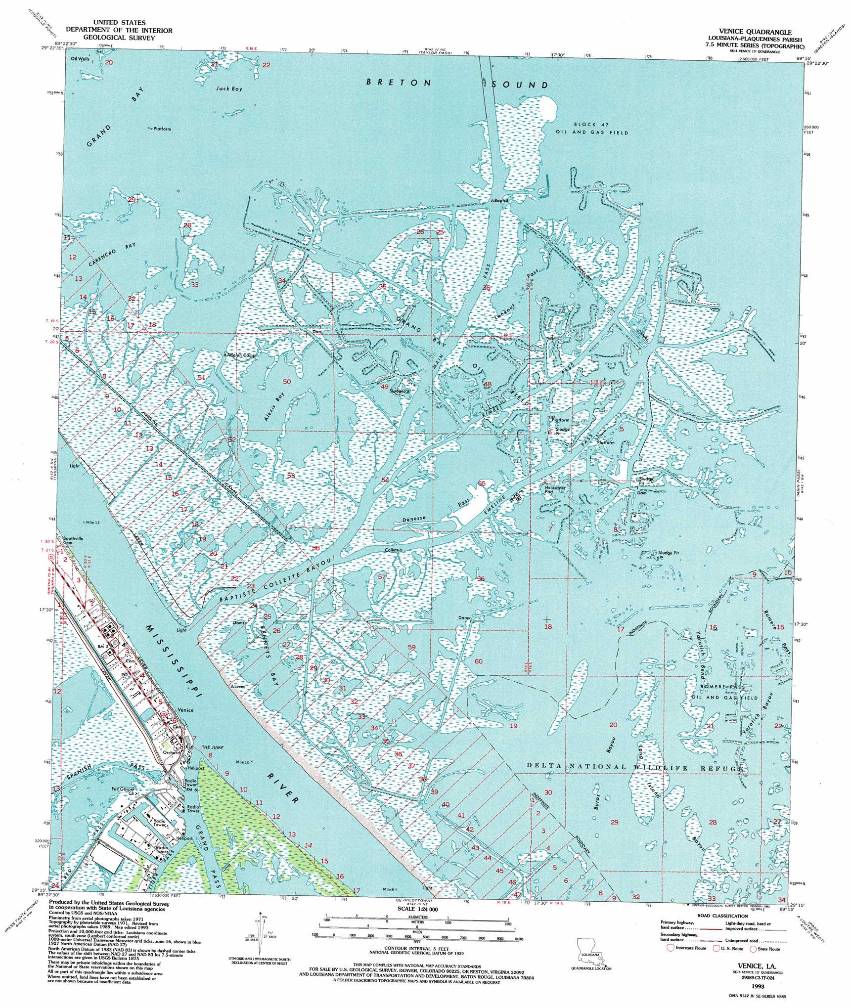
USGS Topo Quad 29089c3 - 1:24,000 scale
| Topo Map Name: | Venice |
| USGS Topo Quad ID: | 29089c3 |
| Print Size: | ca. 21 1/4" wide x 27" high |
| Southeast Coordinates: | 29.25° N latitude / 89.25° W longitude |
| Map Center Coordinates: | 29.3125° N latitude / 89.3125° W longitude |
| U.S. State: | LA |
| Filename: | o29089c3.jpg |
| Download Map JPG Image: | Venice topo map 1:24,000 scale |
| Map Type: | Topographic |
| Topo Series: | 7.5´ |
| Map Scale: | 1:24,000 |
| Source of Map Images: | United States Geological Survey (USGS) |
| Alternate Map Versions: |
Venice LA 1971, updated 1974 Download PDF Buy paper map Venice LA 1971, updated 1984 Download PDF Buy paper map Venice LA 1993, updated 1993 Download PDF Buy paper map Venice LA 1998, updated 2001 Download PDF Buy paper map Venice LA 2012 Download PDF Buy paper map Venice LA 2015 Download PDF Buy paper map |
1:24,000 Topo Quads surrounding Venice
Black Bay South |
||||
Empire |
Coquille Point |
Taylor Pass |
Breton Islands |
|
Buras |
Triumph |
Venice |
Main Pass |
Breton Islands Se |
Bay Coquette |
Pass Tante Phine |
Pilottown |
Pass A Loutre West |
Pass A Loutre East |
Pass Du Bois |
Dixon Bay |
South Pass |
Garden Island Pass |
> Back to 29089a1 at 1:100,000 scale
> Back to 29088a1 at 1:250,000 scale
> Back to U.S. Topo Maps home
Venice topo map: Gazetteer
Venice: Airports
Air Logistics Heliport elevation 0m 0′Chevron USA Incorporated Seaplane Base elevation 1m 3′
Conoco Incorporated Venice Heliport elevation 1m 3′
Era Helicopters Venice Base Heliport elevation -2m -7′
Grand Bay Receiving Station Heliport elevation 0m 0′
Grand Bay Seaplane Base elevation 2m 6′
Marathon Venice Heliport elevation -1m -4′
Phi Venice Heliport elevation 1m 3′
Shell Venice Terminal Heliport elevation -1m -4′
Venice: Bays
Alexis Bay elevation 0m 0′Benneys Bay elevation 0m 0′
Carencro Bay elevation 0m 0′
Grand Bay elevation 0m 0′
Jack Bay elevation 0m 0′
Venice: Channels
Baptiste Collette Bayou elevation 0m 0′Emeline Pass elevation 0m 0′
Kimbel Pass elevation 0m 0′
Main Pass elevation 0m 0′
Venice: Flats
Wilder Flats elevation 0m 0′Venice: Gaps
The Jump elevation 1m 3′Venice: Guts
Buras Bayou elevation 0m 0′Denesse Pass elevation 0m 0′
Lookout Pass elevation 0m 0′
Yaratich Bayou elevation 0m 0′
Yaratich Bend elevation 0m 0′
Venice: Oilfields
Block 47 Oil and Gas Field elevation 0m 0′Grand Bay Oil Field elevation 0m 0′
Venice: Populated Places
Orchard elevation 1m 3′Venice elevation 0m 0′
Venice: Post Offices
Venice Post Office elevation -1m -4′Venice digital topo map on disk
Buy this Venice topo map showing relief, roads, GPS coordinates and other geographical features, as a high-resolution digital map file on DVD:
Gulf Coast (LA, MS, AL, FL) & Southwestern Georgia
Buy digital topo maps: Gulf Coast (LA, MS, AL, FL) & Southwestern Georgia
 & Southwestern Georgia map DVD")