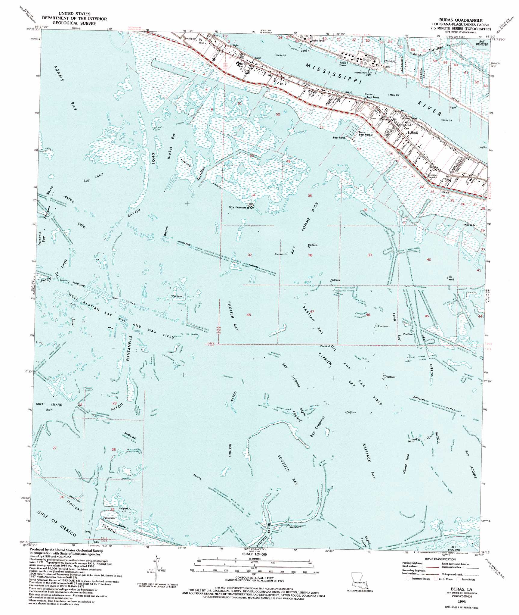
Buras Topo Map Louisiana
To zoom in, hover over the map of Buras
USGS Topo Quad 29089c5 - 1:24,000 scale
| Topo Map Name: | Buras |
| USGS Topo Quad ID: | 29089c5 |
| Print Size: | ca. 21 1/4" wide x 27" high |
| Southeast Coordinates: | 29.25° N latitude / 89.5° W longitude |
| Map Center Coordinates: | 29.3125° N latitude / 89.5625° W longitude |
| U.S. State: | LA |
| Filename: | o29089c5.jpg |
| Download Map JPG Image: | Buras topo map 1:24,000 scale |
| Map Type: | Topographic |
| Topo Series: | 7.5´ |
| Map Scale: | 1:24,000 |
| Source of Map Images: | United States Geological Survey (USGS) |
| Alternate Map Versions: |
Buras LA 1973, updated 1976 Download PDF Buy paper map Buras LA 1993, updated 1994 Download PDF Buy paper map Buras LA 1998, updated 2003 Download PDF Buy paper map Buras LA 2012 Download PDF Buy paper map Buras LA 2015 Download PDF Buy paper map |
1:24,000 Topo Quads surrounding Buras
Pointe A La Hache |
Happy Jack |
Black Bay South |
||
Bay Batiste |
Port Sulphur |
Empire |
Coquille Point |
Taylor Pass |
Bay Ronquille |
Bastian Bay |
Buras |
Triumph |
Venice |
Bay Coquette |
Pass Tante Phine |
Pilottown |
||
Pass Du Bois |
Dixon Bay |
> Back to 29089a1 at 1:100,000 scale
> Back to 29088a1 at 1:250,000 scale
> Back to U.S. Topo Maps home
Buras topo map: Gazetteer
Buras: Airports
West Delta Brock 30 Terminal Seaplane Base elevation 0m 0′Buras: Bays
Bay Cheri elevation 0m 0′Bay Crapaud elevation 0m 0′
Bay Pomme d'or elevation 0m 0′
Cyprien Bay elevation 0m 0′
Skipjack Bay elevation 0m 0′
Buras: Canals
Cazezu Canal elevation 0m 0′Cognevich Canal elevation 0m 0′
Cross Canal elevation 0m 0′
Cuselich Canal elevation 0m 0′
Easterlings Canal elevation 0m 0′
Mingle Canal elevation 0m 0′
Buras: Channels
Mitchell Cut elevation 0m 0′Buras: Dams
Ostrica Lock elevation 2m 6′Buras: Guts
Bayou Auguste elevation 0m 0′Bayou Cheri elevation 0m 0′
Bayou Crapaud elevation 0m 0′
Bayou Fontanelle elevation 0m 0′
Bayou La Chute elevation 0m 0′
Bayou Long elevation 0m 0′
Bayou Pompadour elevation 0m 0′
Bayou Tortillon elevation 0m 0′
Bayou Tortillon elevation 0m 0′
Dry Cypress Bayou elevation 0m 0′
English Bayou elevation 0m 0′
Ferrand Bayou elevation 0m 0′
Scofield Bayou elevation 0m 0′
Buras: Harbors
Buras Boat Harbor elevation 0m 0′Buras: Islands
Pelican Island elevation 1m 3′Buras: Lakes
Adams Bay elevation 0m 0′Bay Jacquin elevation 0m 0′
Bay Pomme d'Or elevation 0m 0′
Drakes Bay elevation 0m 0′
English Bay elevation 0m 0′
Little Bay Pomme d'Or elevation 0m 0′
Long Bay elevation 0m 0′
Mitchell Pond elevation 0m 0′
Scofield Bay elevation 0m 0′
Buras: Levees
Buras Revetment elevation 1m 3′Buras: Oilfields
Bastian Bay Oil and Gas Field elevation 0m 0′Drakes Bay Gas Field elevation 0m 0′
West Bastian Bay Oil and Gas Field elevation 0m 0′
Buras: Populated Places
Buras elevation 0m 0′Ostrica elevation 1m 3′
Quarantine (historical) elevation 1m 3′
Sunrise elevation 0m 0′
Buras: Post Offices
Buras Post Office elevation -1m -4′Buras digital topo map on disk
Buy this Buras topo map showing relief, roads, GPS coordinates and other geographical features, as a high-resolution digital map file on DVD:
Gulf Coast (LA, MS, AL, FL) & Southwestern Georgia
Buy digital topo maps: Gulf Coast (LA, MS, AL, FL) & Southwestern Georgia
 & Southwestern Georgia map DVD")