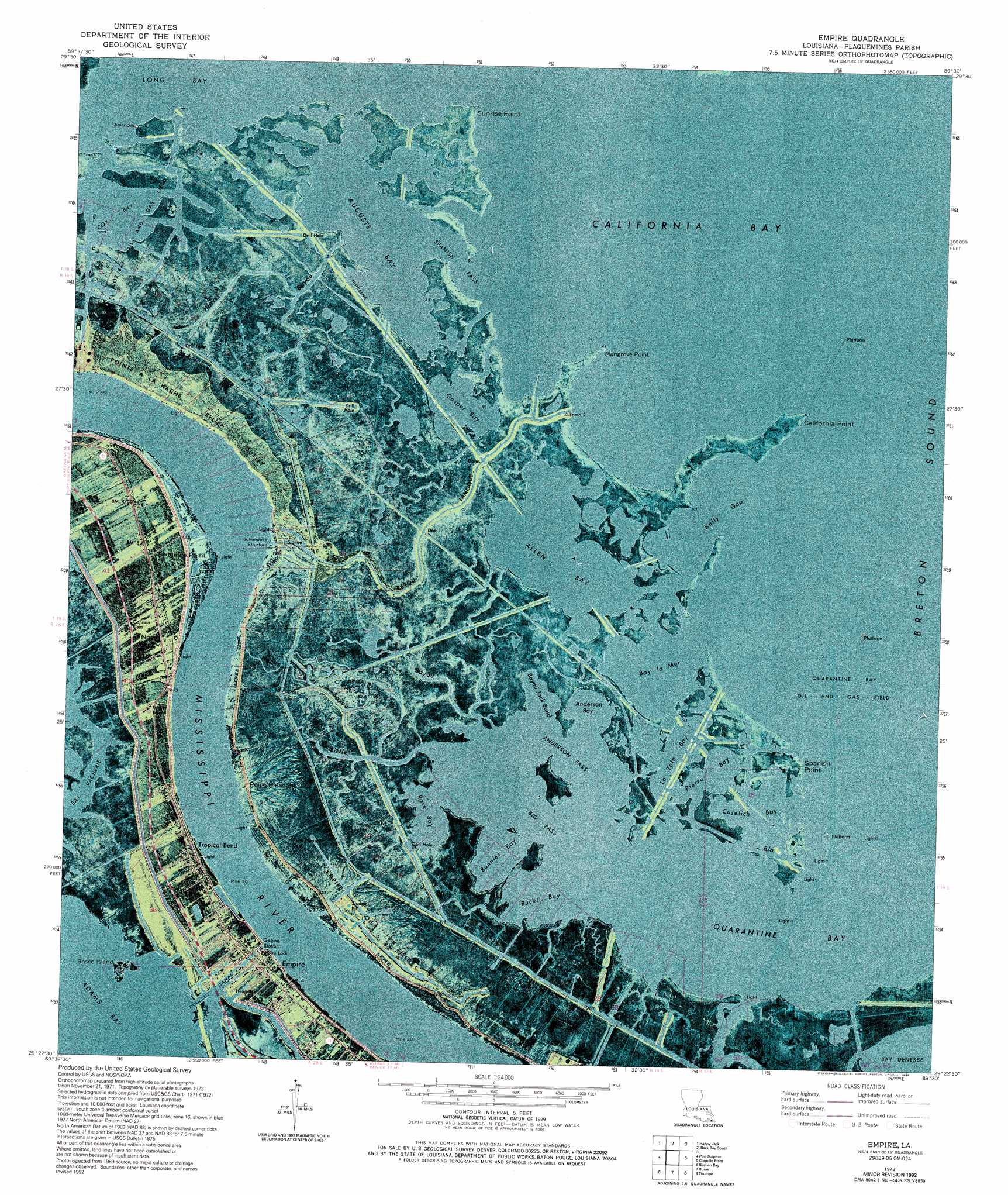
Empire Topo Map Louisiana
To zoom in, hover over the map of Empire
USGS Topo Quad 29089d5 - 1:24,000 scale
| Topo Map Name: | Empire |
| USGS Topo Quad ID: | 29089d5 |
| Print Size: | ca. 21 1/4" wide x 27" high |
| Southeast Coordinates: | 29.375° N latitude / 89.5° W longitude |
| Map Center Coordinates: | 29.4375° N latitude / 89.5625° W longitude |
| U.S. State: | LA |
| Filename: | p29089d5.jpg |
| Download Map JPG Image: | Empire topo map 1:24,000 scale |
| Map Type: | Orthophoto |
| Topo Series: | 7.5´ |
| Map Scale: | 1:24,000 |
| Source of Map Images: | United States Geological Survey (USGS) |
| Alternate Map Versions: |
Empire LA 1973, updated 1976 Download PDF Buy paper map Empire LA 1973, updated 1989 Download PDF Buy paper map Empire LA 1973, updated 1992 Download PDF Buy paper map Empire LA 2012 Download PDF Buy paper map Empire LA 2015 Download PDF Buy paper map |
1:24,000 Topo Quads surrounding Empire
Lake Batola |
Lake Cuatro Caballo |
Black Bay North |
Lake Athanasio |
Point Chicot |
Pointe A La Hache |
Happy Jack |
Black Bay South |
||
Bay Batiste |
Port Sulphur |
Empire |
Coquille Point |
Taylor Pass |
Bay Ronquille |
Bastian Bay |
Buras |
Triumph |
Venice |
Bay Coquette |
Pass Tante Phine |
Pilottown |
> Back to 29089a1 at 1:100,000 scale
> Back to 29088a1 at 1:250,000 scale
> Back to U.S. Topo Maps home
Empire topo map: Gazetteer
Empire: Airports
Calky Terminal Seaplane Base elevation 0m 0′Quarantine Bay Seaplane Base elevation 0m 0′
Shell Pipeline Nairn Heliport elevation -1m -4′
Empire: Bays
Allen Bay elevation 0m 0′Anderson Bay elevation 0m 0′
Auguste Bay elevation 0m 0′
Bay la Mer elevation 0m 0′
Bayou Jack Bend elevation 0m 0′
Bonnies Bay elevation 0m 0′
Bucks Bay elevation 0m 0′
California Bay elevation 0m 0′
Cox Bay elevation 0m 0′
Cuselich Bay elevation 0m 0′
Gasper Bay elevation 0m 0′
Kelly Gap elevation 0m 0′
La Tete Bay elevation 0m 0′
Pierre Bay elevation 0m 0′
Quarantine Bay elevation 0m 0′
Rose Bay elevation 0m 0′
Empire: Bends
Tropical Bend elevation 1m 3′Empire: Canals
Ballandock Canal elevation 0m 0′Ballandock Structure elevation 3m 9′
Bardel Canal elevation 0m 0′
Doullut Canal elevation 0m 0′
Empire: Capes
California Point elevation 0m 0′Mangrove Point elevation 0m 0′
Point Pleasant elevation 2m 6′
Sixtymile Point elevation 1m 3′
Spanish Point elevation 0m 0′
Sunrise Point elevation 0m 0′
Empire: Channels
Anderson Pass elevation 0m 0′Big Pass elevation 0m 0′
Spanish Pass elevation 0m 0′
Empire: Dams
Empire Lock elevation 1m 3′Empire: Guts
Bayou Bio elevation 0m 0′Bayou Jack elevation 0m 0′
Bayou Lamoque elevation 0m 0′
Hacks Bayou elevation 0m 0′
Harris Bayou elevation 1m 3′
Little Pass elevation 0m 0′
Empire: Islands
Bosco Island elevation 0m 0′Empire: Lakes
Bay Vacherie elevation 0m 0′Empire: Levees
Bayou Lamoque Revetment elevation 1m 3′Tropical Bend Revetment elevation 1m 3′
Empire: Oilfields
Empire Oil Field elevation 0m 0′Quarantine Bay Oil and Gas Field elevation 0m 0′
Empire: Parks
Bohemia State Wildlife Management Area elevation 1m 3′Empire: Populated Places
Empire elevation 1m 3′Hesperides elevation 1m 3′
Nairn elevation 0m 0′
Nicholls (historical) elevation 1m 3′
Point Pleasant (historical) elevation 2m 6′
Tropical Bend elevation 0m 0′
Empire: Post Offices
Empire Post Office elevation 1m 3′Empire: Streams
Bayou Tortillon elevation 1m 3′Empire digital topo map on disk
Buy this Empire topo map showing relief, roads, GPS coordinates and other geographical features, as a high-resolution digital map file on DVD:
Gulf Coast (LA, MS, AL, FL) & Southwestern Georgia
Buy digital topo maps: Gulf Coast (LA, MS, AL, FL) & Southwestern Georgia
 & Southwestern Georgia map DVD")