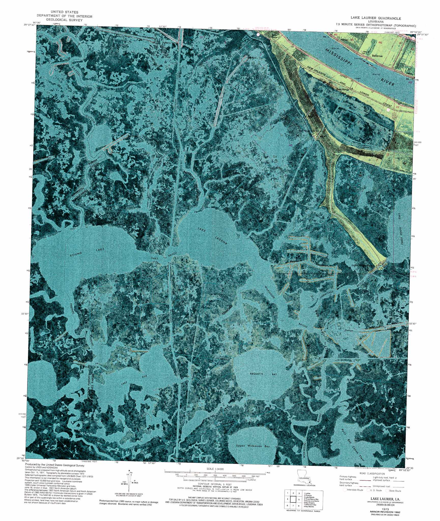
Lake Laurier Topo Map Louisiana
To zoom in, hover over the map of Lake Laurier
USGS Topo Quad 29089e8 - 1:24,000 scale
| Topo Map Name: | Lake Laurier |
| USGS Topo Quad ID: | 29089e8 |
| Print Size: | ca. 21 1/4" wide x 27" high |
| Southeast Coordinates: | 29.5° N latitude / 89.875° W longitude |
| Map Center Coordinates: | 29.5625° N latitude / 89.9375° W longitude |
| U.S. State: | LA |
| Filename: | p29089e8.jpg |
| Download Map JPG Image: | Lake Laurier topo map 1:24,000 scale |
| Map Type: | Orthophoto |
| Topo Series: | 7.5´ |
| Map Scale: | 1:24,000 |
| Source of Map Images: | United States Geological Survey (USGS) |
| Alternate Map Versions: |
Lake Laurier LA 1973, updated 1976 Download PDF Buy paper map Lake Laurier LA 1973, updated 1992 Download PDF Buy paper map Lake Laurier LA 2012 Download PDF Buy paper map Lake Laurier LA 2015 Download PDF Buy paper map |
1:24,000 Topo Quads surrounding Lake Laurier
Lake Cataouatche East |
Bertrandville |
Belle Chasse |
Delacroix |
Yscloskey |
Barataria |
Lafitte |
Phoenix |
Lake Batola |
Lake Cuatro Caballo |
Bay L'Ours |
Three Bayou Bay |
Lake Laurier |
Pointe A La Hache |
Happy Jack |
Golden Meadow Farms |
Bay Dosgris |
Wilkinson Bay |
Bay Batiste |
Port Sulphur |
Mink Bayou |
Bay Tambour |
Barataria Pass |
Bay Ronquille |
Bastian Bay |
> Back to 29089e1 at 1:100,000 scale
> Back to 29088a1 at 1:250,000 scale
> Back to U.S. Topo Maps home
Lake Laurier topo map: Gazetteer
Lake Laurier: Bays
Upper Wilkinson Bay elevation 0m 0′Lake Laurier: Canals
Deer Range Canal elevation 0m 0′Jimmie Canal elevation 0m 0′
Wilkinson Canal elevation 0m 0′
Lake Laurier: Guts
Bayou Dupont elevation 0m 0′Bayou Francais elevation 0m 0′
Bayou McCutchen elevation 0m 0′
Bayou Tambour elevation 0m 0′
Hermitage Bayou elevation 0m 0′
L Bayou Mc Cutchen elevation 0m 0′
Oaks Bayou elevation 0m 0′
Lake Laurier: Lakes
Lake Five elevation 0m 0′Lake Laurier elevation 0m 0′
Petit Bay Chene Fleur elevation 0m 0′
Raquette Bay elevation 0m 0′
Round Lake elevation 0m 0′
Lake Laurier: Levees
Junior Revetment elevation 2m 6′Lake Laurier: Oilfields
Lafitte Oil and Gas Field elevation 0m 0′Lake Hermitage Oil and Gas Field elevation 0m 0′
Lake Laurier: Populated Places
Bellevue elevation 2m 6′Deer Range elevation 0m 0′
Harlem elevation 4m 13′
Lake Judge Perez elevation 1m 3′
Lake Laurier: Streams
Bayou Raquette elevation 0m 0′Lake Laurier digital topo map on disk
Buy this Lake Laurier topo map showing relief, roads, GPS coordinates and other geographical features, as a high-resolution digital map file on DVD:
Gulf Coast (LA, MS, AL, FL) & Southwestern Georgia
Buy digital topo maps: Gulf Coast (LA, MS, AL, FL) & Southwestern Georgia
 & Southwestern Georgia map DVD")