Lake Athanasio Topo Map Louisiana
To zoom in, hover over the map of Lake Athanasio
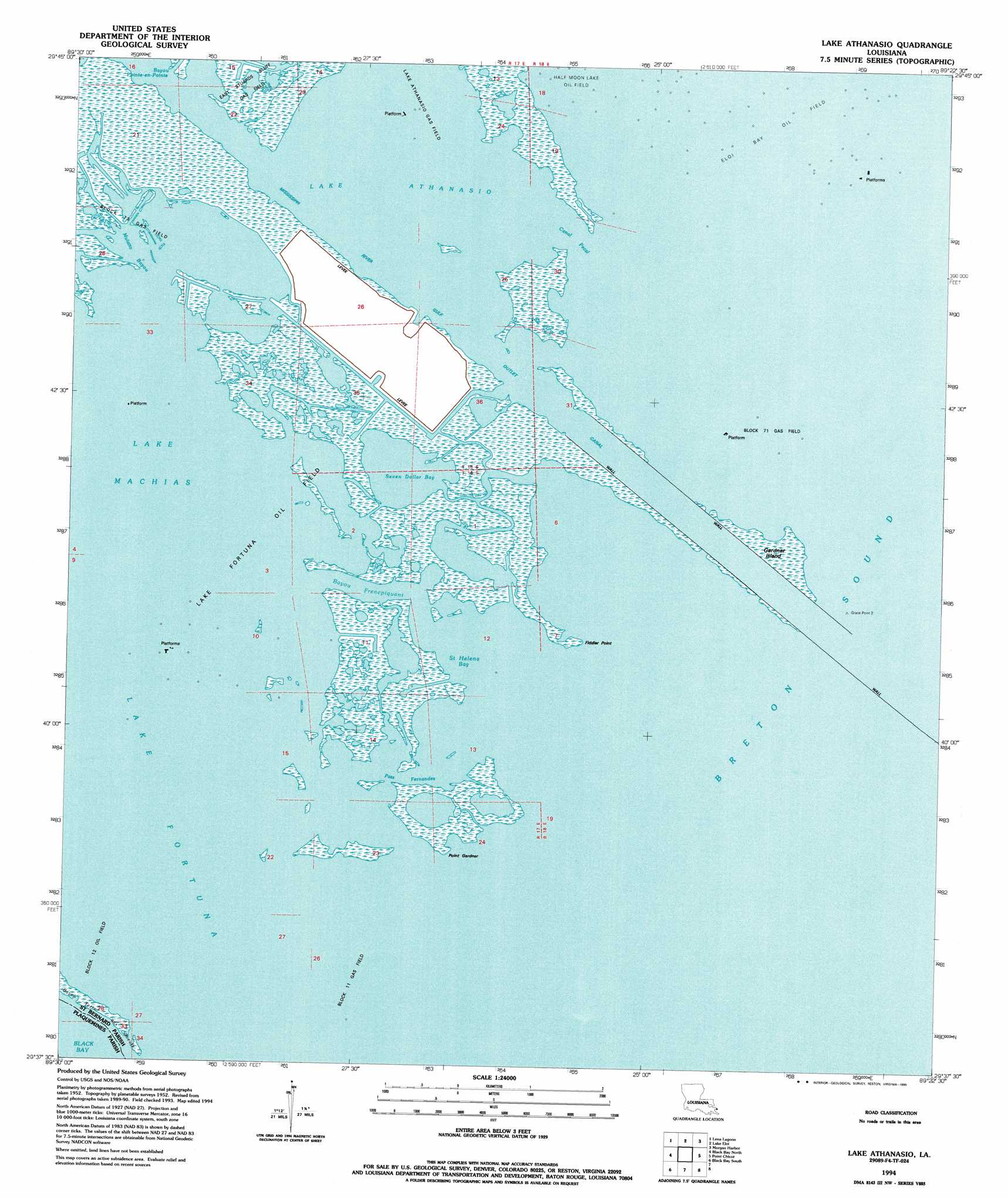
USGS Topo Quad 29089f4 - 1:24,000 scale
| Topo Map Name: | Lake Athanasio |
| USGS Topo Quad ID: | 29089f4 |
| Print Size: | ca. 21 1/4" wide x 27" high |
| Southeast Coordinates: | 29.625° N latitude / 89.375° W longitude |
| Map Center Coordinates: | 29.6875° N latitude / 89.4375° W longitude |
| U.S. State: | LA |
| Filename: | o29089f4.jpg |
| Download Map JPG Image: | Lake Athanasio topo map 1:24,000 scale |
| Map Type: | Topographic |
| Topo Series: | 7.5´ |
| Map Scale: | 1:24,000 |
| Source of Map Images: | United States Geological Survey (USGS) |
| Alternate Map Versions: |
Lake Athanasio LA 1955, updated 1959 Download PDF Buy paper map Lake Athanasio LA 1955, updated 1965 Download PDF Buy paper map Lake Athanasio LA 1994, updated 1995 Download PDF Buy paper map Lake Athanasio LA 2012 Download PDF Buy paper map Lake Athanasio LA 2015 Download PDF Buy paper map |
1:24,000 Topo Quads surrounding Lake Athanasio
Proctor Point |
Pte Aux Marchettes |
Lake Eugenie |
Oak Mound Bayou |
Mitchell Key |
Yscloskey |
Lena Lagoon |
Lake Eloi |
Morgan Harbor |
|
Lake Cuatro Caballo |
Black Bay North |
Lake Athanasio |
Point Chicot |
|
Happy Jack |
Black Bay South |
|||
Port Sulphur |
Empire |
Coquille Point |
Taylor Pass |
Breton Islands |
> Back to 29089e1 at 1:100,000 scale
> Back to 29088a1 at 1:250,000 scale
> Back to U.S. Topo Maps home
Lake Athanasio topo map: Gazetteer
Lake Athanasio: Bays
Lake Fortuna elevation 0m 0′Lake Machias elevation 0m 0′
Saint Helena Bay elevation 0m 0′
Lake Athanasio: Capes
Fiddler Point elevation 1m 3′Grace Point elevation 1m 3′
Point Eloi elevation 1m 3′
Point Fortuna elevation 1m 3′
Point Gardner elevation 1m 3′
Lake Athanasio: Channels
Pass Fernandez elevation 0m 0′Lake Athanasio: Guts
Bayou Frenepiquant elevation 0m 0′Canal Pecal elevation 0m 0′
Mulatto Bayou elevation 0m 0′
Seven Dollar Bay elevation 0m 0′
Lake Athanasio: Islands
Coon Nest Island elevation 1m 3′Gardner Island elevation 1m 3′
Grassy Island elevation 1m 3′
Raccoon Island elevation 1m 3′
Lake Athanasio: Lakes
Lake Athanasio elevation 0m 0′Seven Dollar Bay elevation -1m -4′
Lake Athanasio: Streams
Bayou Terre Aux Boeufs elevation 0m 0′Frenepiquant Bayou elevation 1m 3′
Lake Athanasio digital topo map on disk
Buy this Lake Athanasio topo map showing relief, roads, GPS coordinates and other geographical features, as a high-resolution digital map file on DVD:
Gulf Coast (LA, MS, AL, FL) & Southwestern Georgia
Buy digital topo maps: Gulf Coast (LA, MS, AL, FL) & Southwestern Georgia
 & Southwestern Georgia map DVD")