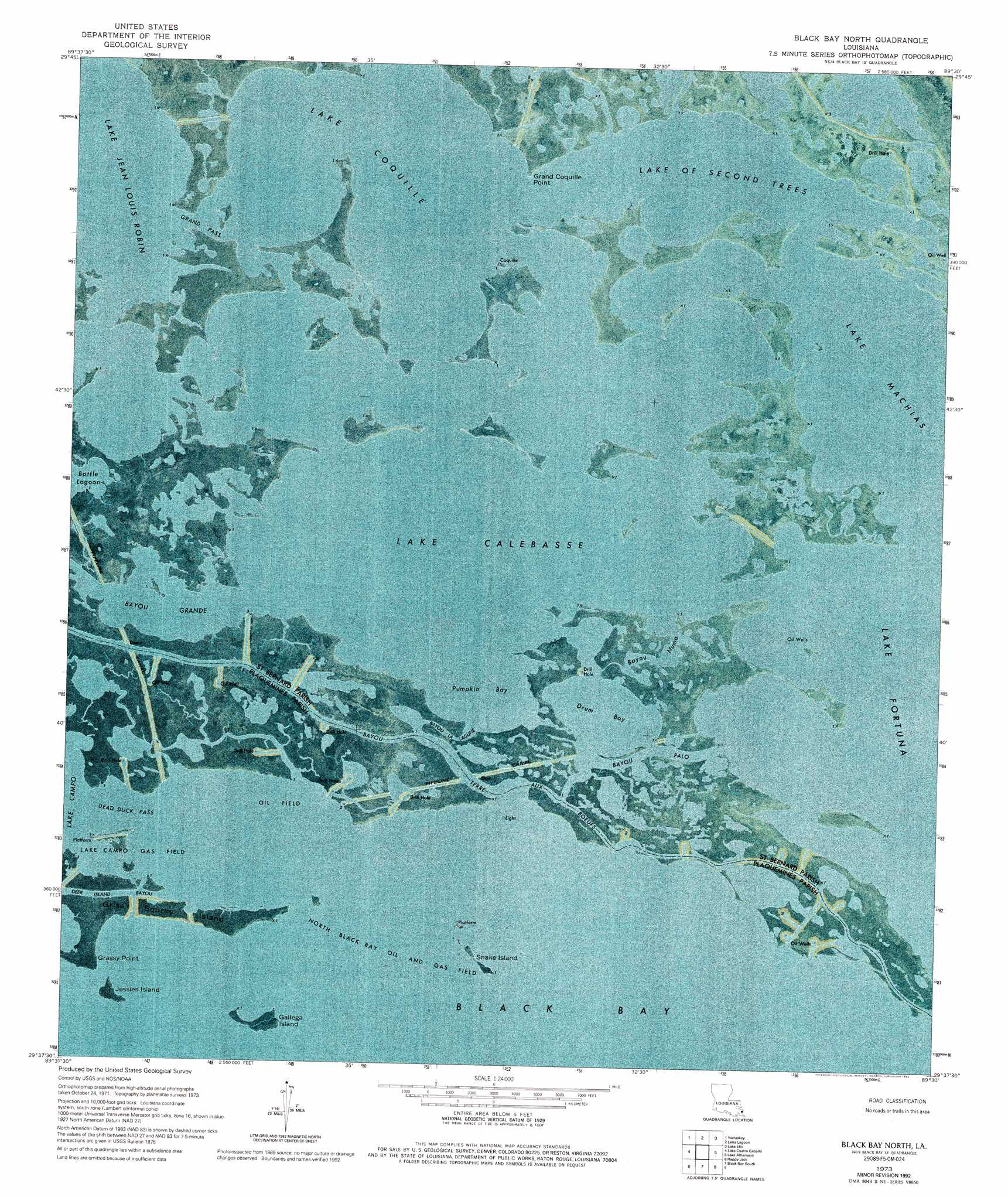
Black Bay North Topo Map Louisiana
To zoom in, hover over the map of Black Bay North
USGS Topo Quad 29089f5 - 1:24,000 scale
| Topo Map Name: | Black Bay North |
| USGS Topo Quad ID: | 29089f5 |
| Print Size: | ca. 21 1/4" wide x 27" high |
| Southeast Coordinates: | 29.625° N latitude / 89.5° W longitude |
| Map Center Coordinates: | 29.6875° N latitude / 89.5625° W longitude |
| U.S. State: | LA |
| Filename: | p29089f5.jpg |
| Download Map JPG Image: | Black Bay North topo map 1:24,000 scale |
| Map Type: | Orthophoto |
| Topo Series: | 7.5´ |
| Map Scale: | 1:24,000 |
| Source of Map Images: | United States Geological Survey (USGS) |
| Alternate Map Versions: |
Black Bay North LA 1973, updated 1976 Download PDF Buy paper map Black Bay North LA 1973, updated 1992 Download PDF Buy paper map Black Bay North LA 2012 Download PDF Buy paper map Black Bay North LA 2015 Download PDF Buy paper map |
1:24,000 Topo Quads surrounding Black Bay North
Martello Castle |
Proctor Point |
Pte Aux Marchettes |
Lake Eugenie |
Oak Mound Bayou |
Delacroix |
Yscloskey |
Lena Lagoon |
Lake Eloi |
Morgan Harbor |
Lake Batola |
Lake Cuatro Caballo |
Black Bay North |
Lake Athanasio |
Point Chicot |
Pointe A La Hache |
Happy Jack |
Black Bay South |
||
Bay Batiste |
Port Sulphur |
Empire |
Coquille Point |
Taylor Pass |
> Back to 29089e1 at 1:100,000 scale
> Back to 29088a1 at 1:250,000 scale
> Back to U.S. Topo Maps home
Black Bay North topo map: Gazetteer
Black Bay North: Bays
Lake Calebasse elevation 0m 0′Lake of Second Trees elevation 0m 0′
Pumpkin Bay elevation 0m 0′
Black Bay North: Capes
Grand Coquille Point elevation 0m 0′Grassy Point elevation 0m 0′
Black Bay North: Channels
Dead Duck Pass elevation 0m 0′Grand Pass elevation 0m 0′
Black Bay North: Guts
Bayou Grande elevation 0m 0′Bayou la Lagune elevation 0m 0′
Bayou Numa elevation 0m 0′
Bayou Palo elevation 0m 0′
Deer Island Bayou elevation 0m 0′
Black Bay North: Islands
Gallega Island elevation 0m 0′Grise Bourbe Island elevation 0m 0′
Jessies Island elevation 0m 0′
Snake Island elevation 0m 0′
Black Bay North: Lakes
Drum Bay elevation 0m 0′Lake Coquille elevation 0m 0′
Black Bay North: Oilfields
Block 12 Oil Field elevation 0m 0′Lake Campo Gas Field elevation 0m 0′
North Black Bay Oil and Gas Field elevation 0m 0′
Black Bay North digital topo map on disk
Buy this Black Bay North topo map showing relief, roads, GPS coordinates and other geographical features, as a high-resolution digital map file on DVD:
Gulf Coast (LA, MS, AL, FL) & Southwestern Georgia
Buy digital topo maps: Gulf Coast (LA, MS, AL, FL) & Southwestern Georgia
 & Southwestern Georgia map DVD")