Lake Batola Topo Map Louisiana
To zoom in, hover over the map of Lake Batola
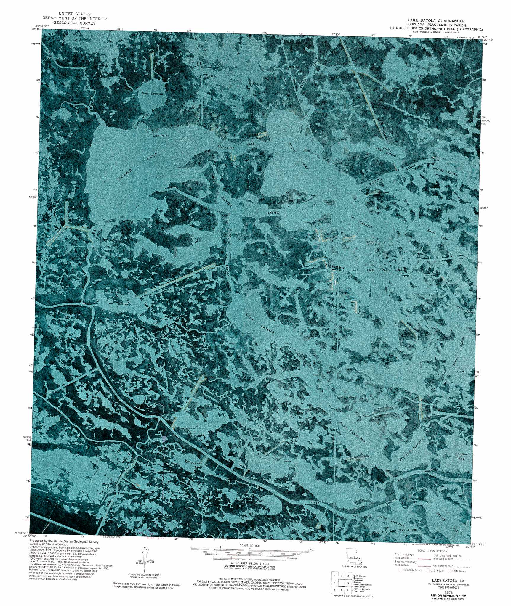
USGS Topo Quad 29089f7 - 1:24,000 scale
| Topo Map Name: | Lake Batola |
| USGS Topo Quad ID: | 29089f7 |
| Print Size: | ca. 21 1/4" wide x 27" high |
| Southeast Coordinates: | 29.625° N latitude / 89.75° W longitude |
| Map Center Coordinates: | 29.6875° N latitude / 89.8125° W longitude |
| U.S. State: | LA |
| Filename: | p29089f7.jpg |
| Download Map JPG Image: | Lake Batola topo map 1:24,000 scale |
| Map Type: | Orthophoto |
| Topo Series: | 7.5´ |
| Map Scale: | 1:24,000 |
| Source of Map Images: | United States Geological Survey (USGS) |
| Alternate Map Versions: |
Lake Batola LA 1973, updated 1976 Download PDF Buy paper map Lake Batola LA 1973, updated 1993 Download PDF Buy paper map Lake Batola LA 2012 Download PDF Buy paper map Lake Batola LA 2015 Download PDF Buy paper map |
1:24,000 Topo Quads surrounding Lake Batola
New Orleans East |
Chalmette |
Martello Castle |
Proctor Point |
Pte Aux Marchettes |
Bertrandville |
Belle Chasse |
Delacroix |
Yscloskey |
Lena Lagoon |
Lafitte |
Phoenix |
Lake Batola |
Lake Cuatro Caballo |
Black Bay North |
Three Bayou Bay |
Lake Laurier |
Pointe A La Hache |
Happy Jack |
Black Bay South |
Bay Dosgris |
Wilkinson Bay |
Bay Batiste |
Port Sulphur |
Empire |
> Back to 29089e1 at 1:100,000 scale
> Back to 29088a1 at 1:250,000 scale
> Back to U.S. Topo Maps home
Lake Batola topo map: Gazetteer
Lake Batola: Capes
Sun Point elevation 1m 3′Lake Batola: Channels
Alligator Pass elevation 0m 0′Sun Bayou elevation 0m 0′
Lake Batola: Guts
Bayou Batola elevation 0m 0′Bayou Canard Gris elevation 0m 0′
Bayou Gentilly elevation 0m 0′
Bayou la Croix elevation 0m 0′
Bayou Long elevation 0m 0′
Bayou Long elevation 0m 0′
Little Crevasse elevation 0m 0′
Orange Bayou elevation 4m 13′
Lake Batola: Lakes
Bakers Bay elevation 0m 0′Bay Jack Nevette elevation 0m 0′
Grand Lake elevation 0m 0′
Lake Batola elevation 0m 0′
Lake Fausan elevation 0m 0′
Little Lake Batola elevation 0m 0′
Petit Lake elevation 0m 0′
Pointe Fienne Bay elevation 0m 0′
Pontons Bay elevation 0m 0′
Shell Lake elevation 0m 0′
Shrimp Lagoon elevation 0m 0′
Sun Lagoon elevation 0m 0′
The Garigue elevation 0m 0′
Lake Batola: Oilfields
Delacroix Oil and Gas Field elevation 0m 0′Lake Petit Gas Field elevation 0m 0′
Lake Batola digital topo map on disk
Buy this Lake Batola topo map showing relief, roads, GPS coordinates and other geographical features, as a high-resolution digital map file on DVD:
Gulf Coast (LA, MS, AL, FL) & Southwestern Georgia
Buy digital topo maps: Gulf Coast (LA, MS, AL, FL) & Southwestern Georgia
 & Southwestern Georgia map DVD")