Morgan Harbor Topo Map Louisiana
To zoom in, hover over the map of Morgan Harbor
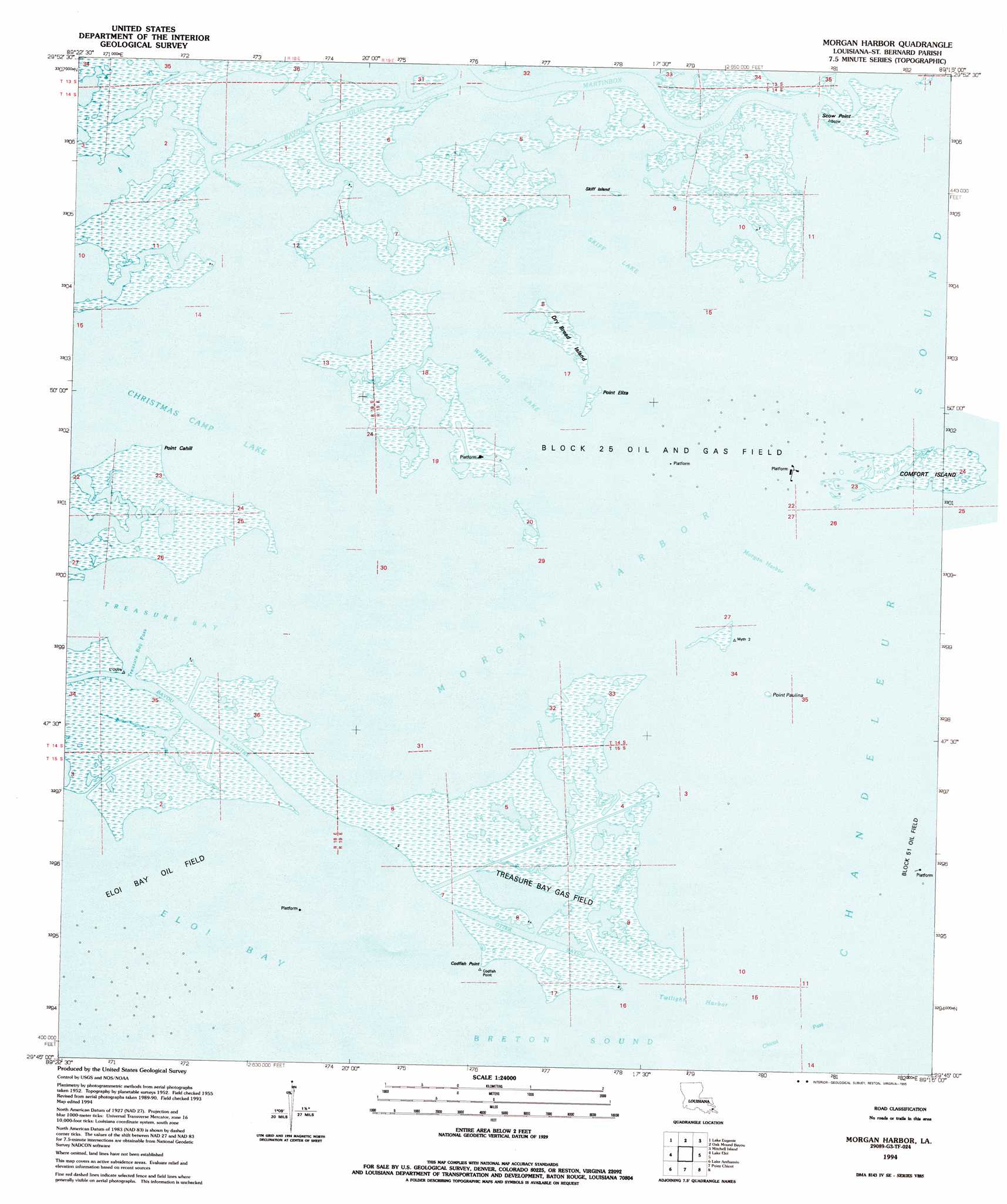
USGS Topo Quad 29089g3 - 1:24,000 scale
| Topo Map Name: | Morgan Harbor |
| USGS Topo Quad ID: | 29089g3 |
| Print Size: | ca. 21 1/4" wide x 27" high |
| Southeast Coordinates: | 29.75° N latitude / 89.25° W longitude |
| Map Center Coordinates: | 29.8125° N latitude / 89.3125° W longitude |
| U.S. State: | LA |
| Filename: | o29089g3.jpg |
| Download Map JPG Image: | Morgan Harbor topo map 1:24,000 scale |
| Map Type: | Topographic |
| Topo Series: | 7.5´ |
| Map Scale: | 1:24,000 |
| Source of Map Images: | United States Geological Survey (USGS) |
| Alternate Map Versions: |
Morgan Harbor LA 1955, updated 1959 Download PDF Buy paper map Morgan Harbor LA 1955, updated 1971 Download PDF Buy paper map Morgan Harbor LA 1994, updated 1995 Download PDF Buy paper map Morgan Harbor LA 2012 Download PDF Buy paper map Morgan Harbor LA 2015 Download PDF Buy paper map |
1:24,000 Topo Quads surrounding Morgan Harbor
False Mouth Bayou |
Malheureux Point |
Three Mile Bay |
Door Point |
|
Pte Aux Marchettes |
Lake Eugenie |
Oak Mound Bayou |
Mitchell Key |
|
Lena Lagoon |
Lake Eloi |
Morgan Harbor |
||
Black Bay North |
Lake Athanasio |
Point Chicot |
||
Black Bay South |
> Back to 29089e1 at 1:100,000 scale
> Back to 29088a1 at 1:250,000 scale
> Back to U.S. Topo Maps home
Morgan Harbor topo map: Gazetteer
Morgan Harbor: Bays
Eloi Bay elevation 0m 0′Morgan Harbor elevation 0m 0′
Twilight Harbor elevation 0m 0′
Morgan Harbor: Capes
Codfish Point elevation 1m 3′Point Cahill elevation 1m 3′
Point Eliza elevation 1m 3′
Point Lydia elevation 1m 3′
Point Paulina elevation 1m 3′
Morgan Harbor: Channels
Chicot Pass elevation 0m 0′Morgan Harbor Pass elevation 0m 0′
Otter Bayou elevation 1m 3′
Scow Pass elevation 0m 0′
Treasure Bay Pass elevation 0m 0′
Morgan Harbor: Guts
Bayou Julia elevation 0m 0′Jules Cutoff elevation 0m 0′
Martinbox Bayou elevation 0m 0′
Old Harry Bayou elevation 0m 0′
Morgan Harbor: Islands
Dry Bread Island elevation 1m 3′Rawhead Island elevation 0m 0′
Skiff Island elevation 1m 3′
Morgan Harbor: Lakes
Christmas Camp Lake elevation 0m 0′Skiff Lake elevation 0m 0′
White Log Lake elevation 0m 0′
Morgan Harbor: Oilfields
Chandeleur Sound Block 25 Oil Field elevation 0m 0′Treasure Island Gas Field elevation 0m 0′
Morgan Harbor: Streams
Bayou la Loutre elevation 0m 0′Morgan Harbor digital topo map on disk
Buy this Morgan Harbor topo map showing relief, roads, GPS coordinates and other geographical features, as a high-resolution digital map file on DVD:
Gulf Coast (LA, MS, AL, FL) & Southwestern Georgia
Buy digital topo maps: Gulf Coast (LA, MS, AL, FL) & Southwestern Georgia
 & Southwestern Georgia map DVD")