Bay Dosgris Topo Map Louisiana
To zoom in, hover over the map of Bay Dosgris
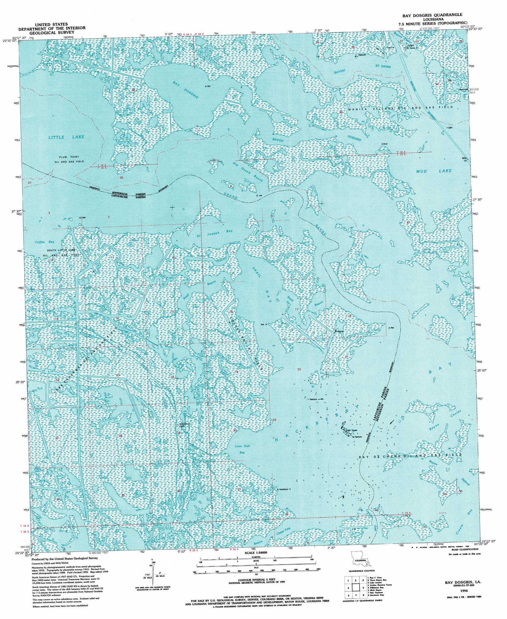
USGS Topo Quad 29090d1 - 1:24,000 scale
| Topo Map Name: | Bay Dosgris |
| USGS Topo Quad ID: | 29090d1 |
| Print Size: | ca. 21 1/4" wide x 27" high |
| Southeast Coordinates: | 29.375° N latitude / 90° W longitude |
| Map Center Coordinates: | 29.4375° N latitude / 90.0625° W longitude |
| U.S. State: | LA |
| Filename: | o29090d1.jpg |
| Download Map JPG Image: | Bay Dosgris topo map 1:24,000 scale |
| Map Type: | Topographic |
| Topo Series: | 7.5´ |
| Map Scale: | 1:24,000 |
| Source of Map Images: | United States Geological Survey (USGS) |
| Alternate Map Versions: |
Bay Dosgris LA 1953, updated 1959 Download PDF Buy paper map Bay Dosgris LA 1953, updated 1963 Download PDF Buy paper map Bay Dosgris LA 1953, updated 1980 Download PDF Buy paper map Bay Dosgris LA 1994, updated 1994 Download PDF Buy paper map Bay Dosgris LA 1998, updated 2001 Download PDF Buy paper map Bay Dosgris LA 2012 Download PDF Buy paper map Bay Dosgris LA 2015 Download PDF Buy paper map |
1:24,000 Topo Quads surrounding Bay Dosgris
Catahoula Bay |
Barataria |
Lafitte |
Phoenix |
Lake Batola |
Cut Off |
Bay L'Ours |
Three Bayou Bay |
Lake Laurier |
Pointe A La Hache |
Golden Meadow |
Golden Meadow Farms |
Bay Dosgris |
Wilkinson Bay |
Bay Batiste |
Bay Courant |
Mink Bayou |
Bay Tambour |
Barataria Pass |
Bay Ronquille |
Pelican Pass |
Leeville |
Caminada Pass |
Grand Isle |
> Back to 29090a1 at 1:100,000 scale
> Back to 29090a1 at 1:250,000 scale
> Back to U.S. Topo Maps home
Bay Dosgris topo map: Gazetteer
Bay Dosgris: Bays
Churn Bay elevation 0m 0′Hackberry Bay elevation 0m 0′
Live Oak Bay elevation 0m 0′
Mud Lake elevation 0m 0′
Saint Joseph Bay elevation 0m 0′
Snail Bay elevation 0m 0′
Bay Dosgris: Channels
Barataria Bay Waterway elevation 0m 0′Bayou Cholas elevation 0m 0′
Bayou Defond elevation 0m 0′
Creole Pass elevation 0m 0′
Grand Bayou elevation 0m 0′
Old Grand Bayou elevation 0m 0′
Bay Dosgris: Guts
Bayou Dosgris elevation 0m 0′Coffee Bayou elevation 0m 0′
East Fork Bayou L'Ours elevation 1m 3′
Manila Bayou elevation 0m 0′
Snail Bayou elevation 0m 0′
Snail Bayou elevation 0m 0′
Bay Dosgris: Lakes
Bay Dosgris elevation 0m 0′Coffee Bay elevation 0m 0′
Bay Dosgris: Oilfields
Bay De Chene Oil Field elevation 0m 0′Coffee Bay Oil Field elevation 0m 0′
Plum Point Oil and Gas Field elevation 0m 0′
South Little Lake Oil and Gas Field elevation 0m 0′
Bay Dosgris digital topo map on disk
Buy this Bay Dosgris topo map showing relief, roads, GPS coordinates and other geographical features, as a high-resolution digital map file on DVD: