Houma Topo Map Louisiana
To zoom in, hover over the map of Houma
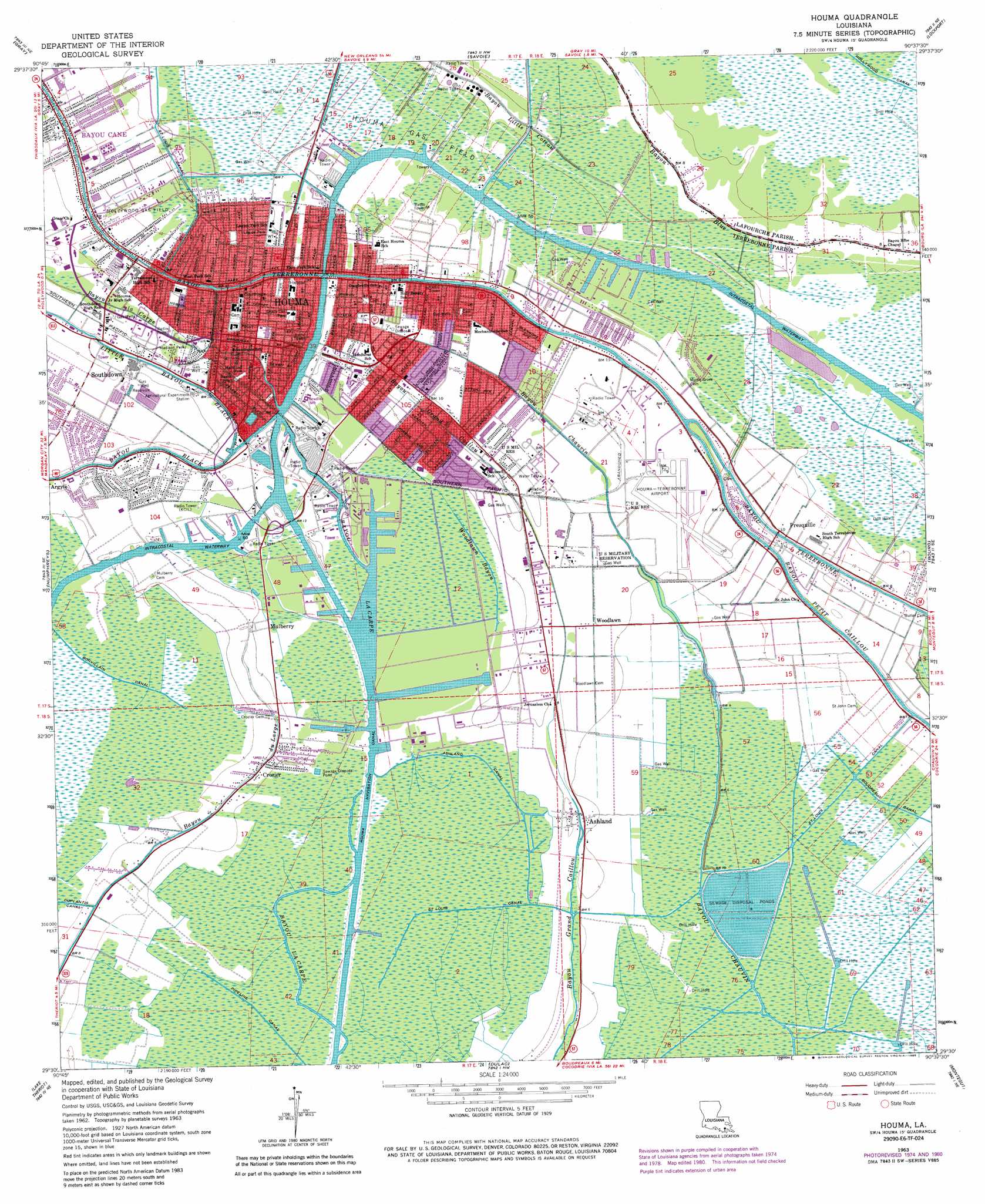
USGS Topo Quad 29090e6 - 1:24,000 scale
| Topo Map Name: | Houma |
| USGS Topo Quad ID: | 29090e6 |
| Print Size: | ca. 21 1/4" wide x 27" high |
| Southeast Coordinates: | 29.5° N latitude / 90.625° W longitude |
| Map Center Coordinates: | 29.5625° N latitude / 90.6875° W longitude |
| U.S. State: | LA |
| Filename: | o29090e6.jpg |
| Download Map JPG Image: | Houma topo map 1:24,000 scale |
| Map Type: | Topographic |
| Topo Series: | 7.5´ |
| Map Scale: | 1:24,000 |
| Source of Map Images: | United States Geological Survey (USGS) |
| Alternate Map Versions: |
Houma LA 1963, updated 1964 Download PDF Buy paper map Houma LA 1963, updated 1975 Download PDF Buy paper map Houma LA 1963, updated 1981 Download PDF Buy paper map Houma LA 1963, updated 1985 Download PDF Buy paper map Houma LA 1998, updated 2000 Download PDF Buy paper map Houma LA 2012 Download PDF Buy paper map Houma LA 2015 Download PDF Buy paper map |
1:24,000 Topo Quads surrounding Houma
Labadieville |
Thibodaux |
Kraemer |
Bayou Boeuf |
Des Allemands |
Gibson |
Gray |
Savoie |
Lockport |
Gheens |
Bayou Cocodrie |
Humphreys |
Houma |
Bourg |
Larose |
Lake Penchant |
Lake Theriot |
Dulac |
Montegut |
Lake Bully Camp |
Lake Mechant |
Bayou Sauveur |
Lake Quitman |
Lake Tambour |
Lake Felicity |
> Back to 29090e1 at 1:100,000 scale
> Back to 29090a1 at 1:250,000 scale
> Back to U.S. Topo Maps home
Houma topo map: Gazetteer
Houma: Airports
Charlie Hammonds Seaplane Base elevation 2m 6′Division 'B' Office Heliport elevation 3m 9′
Energy Heliport elevation 1m 3′
Houma-Terrebonne Airport elevation 2m 6′
Marine Shale Processors Incorporated Heliport elevation 3m 9′
South Louisiana Medical Center Heliport elevation 1m 3′
Terrebonne General Medical Center Heliport elevation 3m 9′
Houma: Canals
Ashland Canal elevation 0m 0′Bonvillain Canal elevation 1m 3′
Houma Canal elevation 0m 0′
Houma: Oilfields
Hollywood Gas Field elevation 2m 6′Houma Gas Field elevation 1m 3′
South Bourg Gas Field elevation 1m 3′
Southeast Houma Gas Field elevation 1m 3′
Southwest Bourg Gas Field elevation 0m 0′
Houma: Parks
Harmond Park elevation 1m 3′Houma Historic District elevation 3m 9′
Legion Park elevation 2m 6′
Madison Park elevation 2m 6′
Shady Oak Park elevation 3m 9′
Williams Avenue Recreation Center elevation 1m 3′
Houma: Populated Places
Argyle elevation 3m 9′Ashland elevation 1m 3′
Crozier elevation 1m 3′
Houma elevation 3m 9′
Mechanicville elevation 3m 9′
Mulberry elevation 1m 3′
Myrtle Grove (historical) elevation 1m 3′
Presquille elevation 3m 9′
Southdown elevation 2m 6′
Sunshine elevation 1m 3′
Woodlawn elevation 2m 6′
Houma: Post Offices
Houma Post Office elevation 3m 9′Houma: Streams
Bayou La Carpe elevation 0m 0′Bayou Little Coteau elevation 2m 6′
Little Bayou Black elevation 0m 0′
Saint Louis Bayou elevation 0m 0′
Woodlawn Bayou elevation 1m 3′
Houma digital topo map on disk
Buy this Houma topo map showing relief, roads, GPS coordinates and other geographical features, as a high-resolution digital map file on DVD: