Bayou Cocodrie Topo Map Louisiana
To zoom in, hover over the map of Bayou Cocodrie
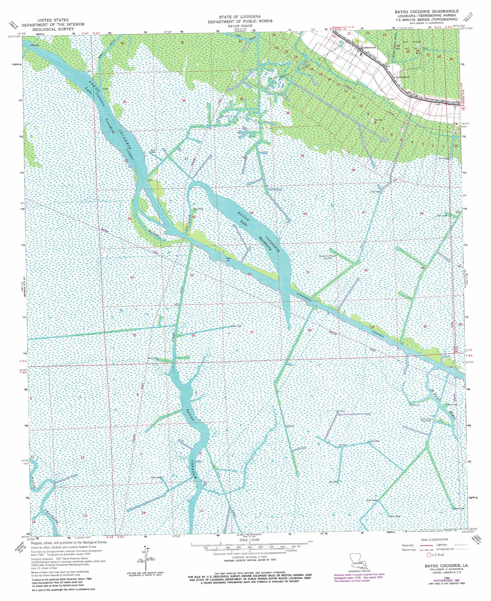
USGS Topo Quad 29090e8 - 1:24,000 scale
| Topo Map Name: | Bayou Cocodrie |
| USGS Topo Quad ID: | 29090e8 |
| Print Size: | ca. 21 1/4" wide x 27" high |
| Southeast Coordinates: | 29.5° N latitude / 90.875° W longitude |
| Map Center Coordinates: | 29.5625° N latitude / 90.9375° W longitude |
| U.S. State: | LA |
| Filename: | o29090e8.jpg |
| Download Map JPG Image: | Bayou Cocodrie topo map 1:24,000 scale |
| Map Type: | Topographic |
| Topo Series: | 7.5´ |
| Map Scale: | 1:24,000 |
| Source of Map Images: | United States Geological Survey (USGS) |
| Alternate Map Versions: |
Bayou Cocodrie LA 1964, updated 1965 Download PDF Buy paper map Bayou Cocodrie LA 1964, updated 1975 Download PDF Buy paper map Bayou Cocodrie LA 1964, updated 1981 Download PDF Buy paper map Bayou Cocodrie LA 2012 Download PDF Buy paper map Bayou Cocodrie LA 2015 Download PDF Buy paper map |
1:24,000 Topo Quads surrounding Bayou Cocodrie
Napoleonville Sw |
Grassy Lake |
Labadieville |
Thibodaux |
Kraemer |
Morgan City |
Amelia |
Gibson |
Gray |
Savoie |
Morgan City Sw |
Morgan City Se |
Bayou Cocodrie |
Humphreys |
Houma |
Plumb Bayou |
Carencro Bayou |
Lake Penchant |
Lake Theriot |
Dulac |
Fourleague Bay |
Lost Lake |
Lake Mechant |
Bayou Sauveur |
Lake Quitman |
> Back to 29090e1 at 1:100,000 scale
> Back to 29090a1 at 1:250,000 scale
> Back to U.S. Topo Maps home
Bayou Cocodrie topo map: Gazetteer
Bayou Cocodrie: Canals
Copasaw Canal elevation 0m 0′Huth Canal elevation 0m 0′
Bayou Cocodrie: Lakes
Lake Cocodrie elevation 0m 0′Lake Hackberry elevation 0m 0′
Bayou Cocodrie: Oilfields
Bayou Copasaw Gas Field elevation 1m 3′East Gibson Gas and Oil Field elevation 1m 3′
Gibson Oil Field elevation 0m 0′
Northeast Gibson Oil Field elevation 1m 3′
Saint Bayou Gas Field elevation 0m 0′
South Humphreys Gas Field elevation 0m 0′
Bayou Cocodrie: Populated Places
Greenwood elevation 0m 0′Bayou Cocodrie: Streams
Saint Paul Bayou elevation 0m 0′Bayou Cocodrie digital topo map on disk
Buy this Bayou Cocodrie topo map showing relief, roads, GPS coordinates and other geographical features, as a high-resolution digital map file on DVD: