Catahoula Bay Topo Map Louisiana
To zoom in, hover over the map of Catahoula Bay
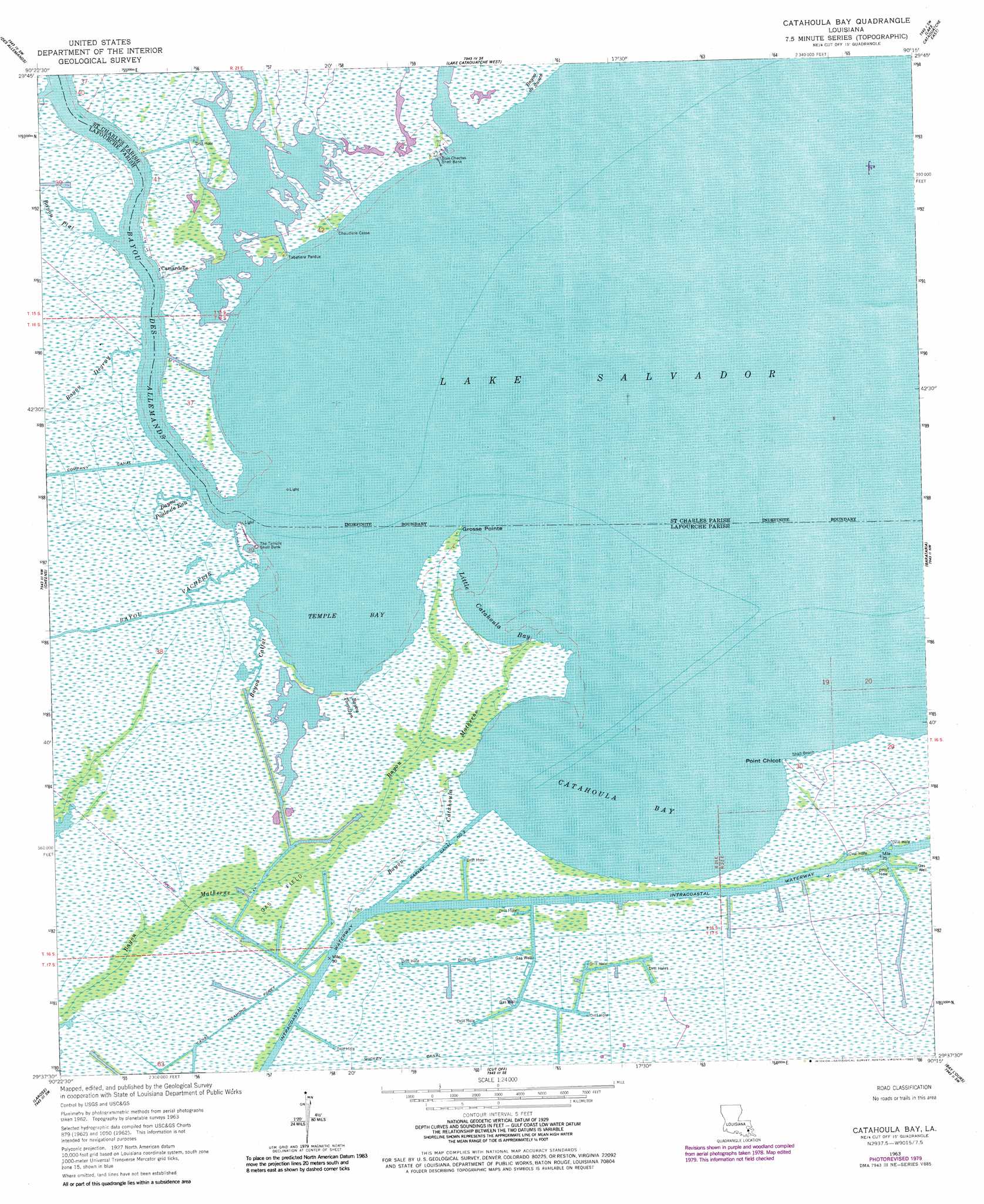
USGS Topo Quad 29090f3 - 1:24,000 scale
| Topo Map Name: | Catahoula Bay |
| USGS Topo Quad ID: | 29090f3 |
| Print Size: | ca. 21 1/4" wide x 27" high |
| Southeast Coordinates: | 29.625° N latitude / 90.25° W longitude |
| Map Center Coordinates: | 29.6875° N latitude / 90.3125° W longitude |
| U.S. State: | LA |
| Filename: | o29090f3.jpg |
| Download Map JPG Image: | Catahoula Bay topo map 1:24,000 scale |
| Map Type: | Topographic |
| Topo Series: | 7.5´ |
| Map Scale: | 1:24,000 |
| Source of Map Images: | United States Geological Survey (USGS) |
| Alternate Map Versions: |
Catahoula Bay LA 1963, updated 1964 Download PDF Buy paper map Catahoula Bay LA 1963, updated 1971 Download PDF Buy paper map Catahoula Bay LA 1963, updated 1980 Download PDF Buy paper map Catahoula Bay LA 2012 Download PDF Buy paper map Catahoula Bay LA 2015 Download PDF Buy paper map |
1:24,000 Topo Quads surrounding Catahoula Bay
Lac Des Allemands |
Hahnville |
Luling |
New Orleans West |
New Orleans East |
Bayou Boeuf |
Des Allemands |
Lake Cataouatche West |
Lake Cataouatche East |
Bertrandville |
Lockport |
Gheens |
Catahoula Bay |
Barataria |
Lafitte |
Bourg |
Larose |
Cut Off |
Bay L'Ours |
Three Bayou Bay |
Montegut |
Lake Bully Camp |
Golden Meadow |
Golden Meadow Farms |
Bay Dosgris |
> Back to 29090e1 at 1:100,000 scale
> Back to 29090a1 at 1:250,000 scale
> Back to U.S. Topo Maps home
Catahoula Bay topo map: Gazetteer
Catahoula Bay: Bays
Catahoula Bay elevation 0m 0′Temple Bay elevation 0m 0′
Catahoula Bay: Beaches
Shell Beach elevation 0m 0′Catahoula Bay: Canals
Harvey Canal Number Two elevation 0m 0′Wickey Canal elevation 0m 0′
Catahoula Bay: Capes
Grosse Pointe elevation 0m 0′Point Chicot elevation 0m 0′
Catahoula Bay: Guts
Bayou Catahoula elevation 1m 3′Bayou de Sauce elevation 0m 0′
Bayou Poule De Eau elevation 0m 0′
Bayou Tortillon elevation 1m 3′
Catahoula Bay: Lakes
Lake Salvador elevation 0m 0′Catahoula Bay: Oilfields
Larose Oil and Gas Field elevation 0m 0′Point Chicot Gas Field elevation 0m 0′
Catahoula Bay: Populated Places
Camardelle elevation 1m 3′Chaudiere Casse elevation 0m 0′
Tabatiere Perdue elevation 0m 0′
Catahoula Bay: Streams
Bayou Calfat elevation 0m 0′Bayou Degruy elevation 0m 0′
Bayou des Allemands elevation 0m 0′
Bayou Matherne elevation 0m 0′
Bayou Plat elevation 1m 3′
Bayou Vacherie elevation 0m 0′
Catahoula Bay digital topo map on disk
Buy this Catahoula Bay topo map showing relief, roads, GPS coordinates and other geographical features, as a high-resolution digital map file on DVD: